Hot And Humid Trend Continues Through The Weekend

Wednesday

melting ice cream GIF by jsot

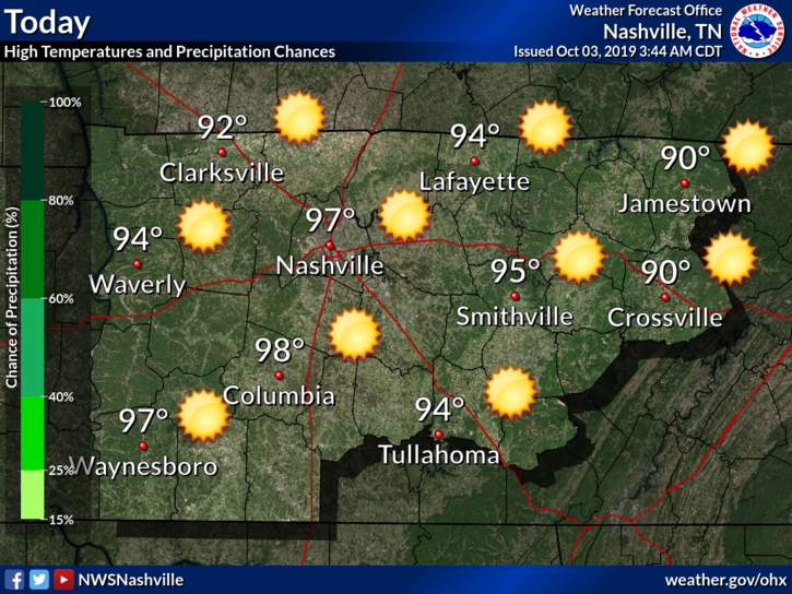
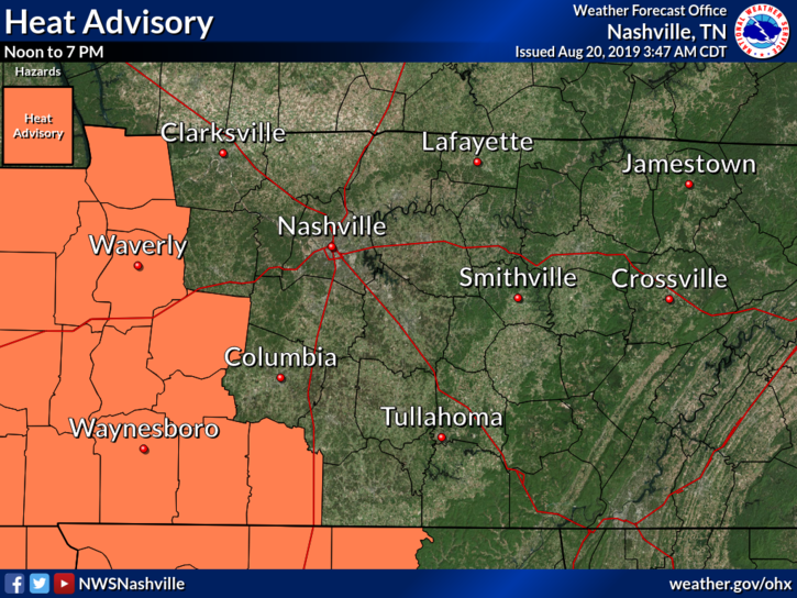
You’re probably going to feel like this ice cream cone as you step outside this afternoon. Another hot and nasty day ahead of us today, high of 98°. Yes, you read that right, not a typo.

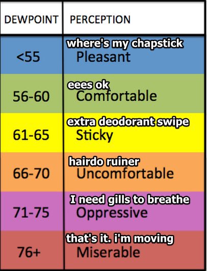
Dewpoints around 70° won’t give us any relief along with the almost triple digit air temperatures, allowing our heat index to climb above 100° this afternoon.

There is a bit of a rain/storm chance this afternoon, however, that could bring us some sort of relief from the current heat wave. The latest HRRR has some pop up showers and storms moving out of the southwest and a couple scattered downpours developing between 2PM-8PM:

[Editor’s Note: These rain chances are similar to what we saw yesterday. Not everyone will see rain. But, if you were under one of the storms yesterday, you know how angry they were. It’s possible for storms to get angry again today in the form of gusty straight line winds that can bring down tree branches. If those branches meet power lines on the way down, there could be scattered power outages once again. Now, for the HRRR:]

Thursday and Friday

More of the nastiness thanks to the ridge of high pressure. Hot and humid, highs in the upper 90s. Dewpoint in the low 70s.


A small chance of a shower/storm Thursday, but other than that mostly sunny, and did I mention hot?

The Weekend

A bit cooler for the weekend, but not by much. Still hot and muggy with highs in the mid 90s.

A slight chance for some thunderstorm development is possible during the afternoons on Saturday and Sunday, but still uncertain on ETA’s since we are still a few days out.

adorable dog GIF

Don’t know about you guys, but I’m ready for some fall-type weather.

september 11 lights GIF

#NeverForget

Check back for more updates!


Nice This Weekend, Hot And Humid Next Week

Friday

Another hot and humid one in store for us today to end off the work week.

We’ll be up to a toasty 90° this afternoon for the high. Dewpoint values continually get higher as the day goes on, reaching up to near 70° by later this evening while everyone is out enjoying some Friday night football.

Those football players are going to need lots of water tonight to avoid cramps!

Very Slight Rain Chance

Also for this evening, a weak boundary moves in from the Northwest, bringing a small chance for an isolated shower during tonight’s games, but nothing close to a washout. Here’s the latest HRRR model:

Odds are you won’t see any rain, but a few sprinkles aren’t completely out of the question. Can’t blame me now if you get a pop-up shower :).

Sunny Weekend

Dewpoints in the low 60s for this weekend. Yay!

We’ll cool off a bit for Saturday, up to 86° for the high. Sunday is almost copy and paste from Saturday, but a bit warmer, up to 91°. A great weekend for some outdoor plans!

football video GIF

Hot And Muggy Week Ahead

Rain chances begin to increase as we approach mid-week, but still not all that great.

We’re going to be feeling the heat this week, with projected highs climbing into the mid to upper 90s.

Dewpoints climb along with the temperatures into the upper 60s. Nasty. Hot. Sweaty.

Sweating Heat Wave GIF by GIF-THIS

Everyone have a great end to their workweek and check back for more updates!

Dry and Sunny Week Ahead; Not Much More Than That

Labor Day

The sun sticks around with us again for Labor Day! We’ll probably stay clear of any showers here in Middle Tennessee, with a bit of an increased rain chance off to our East.

It’ll be a little sticky out as well, dewpoints in the upper 60s-low70s. High of 91° this afternoon.

Happy Labor Day GIF by Animation Domination High-Def

The Week Ahead

Sun, sun, and more sun!

Tuesday and Wednesday: We could see some patchy fog in the morning as everyone heads back to work from the long weekend. Bit warmer moving into Tuesday and Wednesday afternoon thanks to a high pressure moving in from the plains, giving us practically no chance for rain. High temps around 92°. Dewpoints in the upper 60s will make way for a sticky and hot afternoon over the next couple of days.

Thursday and Friday: Temperatures will cool off behind a cold front moving in, especially Thursday and Thursday night. Highs in the mid 80s for Thursday, and low 90s for Friday. Much lower humidity is in store for us to end off the workweek as well.

Weekend: Still mostly sunny and high temperatures in the upper 80s.

happy zweites deutsches fernsehen GIF by ZDF

Update On Hurricane Dorian

Dorian remains a Category 5 as of this morning with sustained winds at 160 mph. It has slowed down and it basically stalling over the Bahamas moving to the West at just 1mphDorian is expected to make a Northern turn later today and tomorrow and ride up the East coast of Florida and up toward the Carolinas. 

cone graphic

What does this mean for us? 

Not much. Here’s what the NWS-Nashville has to say:

“Since Dorian is taking more of a NNE track after passing off of the NC coast, some shortwave ridging will move in Friday ahead of the strong upper high over the southern Plains, which will raise [our] temps a bit on Friday.”

Check back for more updates!

Sun And More Sun For The Holiday Weekend And Beyond

Friday

Happy end of the work week everyone! Lots and lots of sun for the rest of today. Temperatures will rise up to near 91° for the high, combining with lower dewpoints in the low 60s to make way for a great evening for some outdoor plans.

lets go raise the roof GIF by VH1

Labor Day Weekend

Holiday weekend + beautiful weather =

happy tiger woods GIF

With the sunny forecast for this weekend, I think we’re all feeling like Tiger.

We’ll have plenty of sun and just a couple clouds in store for us. A high pressure sitting over Middle Tennessee will keep rain chances out of question for this weekend, allowing for our temperatures to be a little bit warmer, near 93° for both Saturday and Sunday. Dewpoint values will be in the upper 60s, so it may be a bit muggy, but not opressive.

This pretty much guarantees a perfect opportunity to head down to Public Square Park this weekend for some great music at “Live On The Green”.

Go enjoy some free live music and soak up the sun this weekend!

Next Week

Our sunny and warm trend continues into next week, highs in the low 90s. Our next rain chance could possibly come mid next week, just a pop-up storm or two during the afternoon.

As you can see from the 7 day rain forecast map, there’s not too much in store for us. However, for our friends in Florida, that’s a different story.

Speaking of Florida…Here’s An Update On Hurricane Dorian

As I’m sure you all have heard by now, Dorian is now a Hurricane, a major one at that, now at Category 3 strength with 115mph winds. Dorian is still expected to become a Category 4 storm as it approaches the East coast of Florida. This could potentially be a very dangerous situation for those living in that area, so if you have friends or family living there, be sure they have all of the information.

cone graphic

Will Hurricane Dorian impact us here in Middle Tennessee? Probably not. Here’s what the NWS-Nashville has to say about that:

“Models keep the strong upper high over the Plains which should keep Dorian away from the mid state and any of it`s impacts. One welcomed effect from the upper high as well as  Dorian will be northerly/northwesterly flow aloft, which should help cool off temps a bit next Thursday and into next weekend.”

Stay updated with us on twitter @NashSevereWx and come back for more updates!

Rain Today And Tomorrow, Clear And Pleasant After That

Monday

If you have a case of the “Monday’s” today, the weather certainly isn’t helping out.

Widespread rain and a few thunderstorms are the story for today, especially during the late morning and early afternoon hours. The latest HRRR model shows rain being mostly light, except for a couple areas of heavier rain, and it mostly moving out of the area around 5PM-6PM:

The NAM3 model thinks most of the widespread rain stays off to our East, not leaving us with much this afternoon:

Only 80° for the high. We may top 80° if the clouds clear but looking at satellite just before 11 AM, clearing appears unlikely:

Tuesday

Kinda like Monday, except rain in the afternoon instead of in the morning.

angry mr krabs GIF by SpongeBob SquarePants

A cold front will be making its way through Middle Tennessee Tuesday and Tuesday evening. This will cause more showers and maybe weak storms. Still humid, with temps below normal.

The HRRR thinks it’s possible we’ll see a shower around lunch:

With the main line arriving early evening along the cold front:

The NAM3 thinks it’ll rain along the cold front Tuesday evening, as you can see in the model run:

Heavy rain Tuesday night should be brief, with a low-end chance of lightning.

MONDAY AND TUESDAY RAIN TOTALS

Wednesday & The Rest Of The Workweek

By Wednesday the rain will finally be heading out of our area and tapering off and remain rain-free for the rest of the week.

The sun returns, but our temperatures will stay below normal through the week, giving us a beautiful forecast to look forward to. Highs are expected to be in the mid to upper 80s, along with much lower dewpoints in the low 60s.

90s good job GIF

Check back for more updates and have a great start to your workweek!


Showers And Storms Through Mid Next Week

Friday

Rain, rain go away. I know it’s Friday and the start of the weekend, but outdoor plans might be out of the question for this evening.

Scattered showers and thunderstorms will be moving through Middle Tennessee mainly after noon and into this evening. Here’s the latest HRRR model, showing these pop up thunderstorms putting a damper on our Friday afternoon and evening:

The good news from all the rain? Lower high temperatures! We’ll be up to 85° for the high this afternoon, but the humidity will stick around with dewpoint values in the low 70s.

We don’t exactly get rid of this wet pattern tonight. It is going to follow us into the weekend.

SATURDAY

Saturday will give us our lowest chance for showers and storms over the next few days. The NAM not really showing much of anything for the afternoon and into the evening:

We’ll be cooler once again, high of 84°, along with some lower humidity. Some of us could see a stray shower or two, some of us won’t. That’s why these showers are called “isolated”. Besides the possibility for a shower or two we’ll remain partly cloudy and could even see a peak of sun here and there.

SUNDAY

Rain chances go back up on Sunday. Scattered showers develop into more widespread rain and thunderstorms during the afternoon and moving into the evening hours.

Much cooler than normal once again, the high only being near 83°. 

cold frosty the snowman GIF

The Workweek

The wet pattern continues through mid-week. Temperatures below normal, in the upper 80s. 

Rain finally tapers off by mid week, giving us a much needed break to end off the workweek

RAIN TOTALS

By the time Thursday rolls around Nashville could see up to 2-4″ of total rainfall.

Grab that umbrella and stay dry this week! Check back for more updates as always.


Very Hot & Humid, Rain Coming in this Week.

Hot Tuesday

The heat index should reach 105° just west of us. They get the Heat Advisory. We don’t.

We just missed out.

Our heat index should reach up to 104° in Nashville & Will Co today, thanks to the combination of our high temperature of 96° and dewpoint values in the low 70s.

Tuesday’s Rain Chances

TWO TYPES

First, pop up, slow moving storms by late afternoon – early tonight are possible. Exactly where is anyone’s guess.

Second, tonight storms will drop south from the Ohio River, southeast through Kentucky, in our direction. For these the Storm Prediction Center thinks those north of I-40 have a “Marginal” (1/5) risk for some strong to severe storms this afternoon. This includes potential for damaging wind gusts. Storms should weaken on arrival, and will probably be no big deal. We will watch it today.

WEATHER MODELS, POSSIBLE TIMING

The HRRR model shows both types. First, isolated storms popping up after 2PM, then (#2) more widespread showers and storms arriving between 8PM-9PM, but weakening as they approach the area:

The NAM3 model predicts the storms will be a bit stronger than the HRRR predicts, but still weakening. NAM3 ETA about the same as HRRR, 8PM-9PM:

Be flexible on timing. Models often do a bad job timing these I-24 specials.

Rest of the Workweek

Wednesday we don’t get too much of a break from this heat, as the heat index could be 100°-105° once again. Expect randomly placed showers and storms during the evening hours and into the early morning hours:

Thursday and Friday we get a break from the heat thanks to a cold front coming from the North. The tradeoff is an increase in rain.

Highs stick around the low 90s, and mainly isolated showers for Thursday and more widespread rain on Friday, especially Friday night.

This could cause some problems for those of you heading out to the Live On The Green musical festival on Thursday, so you’re may need an umbrella and maybe rain boots if you’re heading out to Public Square Park this week, just to be safe.

.blunt talk singing GIF by Patrick Stewart

The Weekend

The sun returns to us for some of the weekend. Cooler temperatures, in the upper 80s. 

A chance for some summer afternoon pop-up showers are possible. For those of you heading out to Nissan Stadium to watch some preseason action against the Steelers, there is a chance for some showers, but lots of uncertainty for now. Models are flipping back and forth and we’re still a few days out so this could change of course.

2018 nfl football GIF by NFL

Editor’s Note: that guy in the red hat, far left, has never seen Remember the Titans.

As always check back for more updates!


Hot And Dry This Weekend, Rain Chances Return Next Week

Friday

It’s a quiet and hot one out there today! The high today will be around 93° and mostly sunny. Dewpoint values will be in the mid 60s, so a little sticky, but not unbearable.

These high temperatures over 90° will continue over the next few days as we progress into the weekend.

The Weekend

If you have outdoor plans this weekend, we will be clear of rain, but the heat might affect how long you want to be outside.

The weekend is going to be a lot like our Friday, but a little hotter.

High temperatures near 96° for both Saturday and Sunday. Heat index values over 100° are possible.

hot heat wave GIF

We could possibly see a couple showers Sunday afternoon. Here’s what the NWS-Nashville has to say:

“Overall, don’t expect to see any precipitation until Sunday as a weak upper
trough axis passes and even then, it will likely be isolated at
best.”

The Workweek

Rain chances start to build its way back into the forecast for next workweek, as well as the humidity.

oh no help GIF by Ethan Barnowsky

Typical summer afternoon pop-up showers are possible every afternoon next week. No severe weather is expected, however.

High temperatures in the mid 90s for most of the week, and potentially a little cooler to end off the workweek come Thursday and Friday of next week.

Have a great start to your weekend and stay cool! Check back for more updates!

Dangerous Heat This Afternoon, Then Strong Storms Possible

Storms Moving Out

Strong/severe storms moved through this afternoon and evening dropping a lot of rain, lots of lightning, some wind and some hail. These storms have pushed to the S and SE and should be out of our area soon.

Rest Of The Workweek

After the storms roll out tonight (no overnight storms expected), we begin to clear up and see the sun return.

Wednesday will be a nice one. Much cooler than our Tuesday with a high of 89°. However, those sticky dewpoint values are going to stick with us in the upper 60s. 

Thursday will be a great day to get out and enjoy some outdoor plans as well. The first day of the Live On The Green Music Festival looks to be in great shape for those of you heading to Public Square Park. Much like Wednesday, we’ll be mostly sunny, and a bit warm at 90° for the high. Although, not as humid with dewpoint values near 64. 

Nashville Tn GIF by Live On The Green Music Festival

To end off the workweek on Friday, temperatures will be on the rise once again, into the mid 90s for the high in the afternoon. No rain chances as of now. Just a hot and sunny one for our Friday.

The Weekend

For now the weekend is looking to be HOT. Highs possibly in the mid to upper 90s are possible as we progress through the weekend with the sun beating down on us here in Middle Tennessee.

Sunday could see a small chance for a couple pop-up afternoon showers, but the majority of the weekend is shaping out to remain dry and hot.

If you have any weekend plans outside, please stay weather aware and take the precautions necessary to stay safe from dangerous heat, as we see a lot of this time of the year.

fox 6 summer GIF by WBRC FOX6 News

Check back for more updates!


Some Wet, Some Dry Through The Week

Tuesday

We’ve got a normal summer week ahead of us.

We’ll stay mostly dry today, partly cloudy. High temperature near 91°.

We can’t completely rule out an isolated shower or storm this afternoon. But rain is unlikely.

Tonight, a line of storms moving from our northwest will move in from I-24. We call them “I-24 Specials,” storms getting caught in NW winds. These are common summertime events.

The HRRR model believes thinks the line will stay strong, with most storms passing just to our NE. They may wake you up.

The NAM3 model predicts stronger storms holding together, hitting us after midnight into the early morning hours of Wednesday:

No tornado or severe concerns. Mostly just lightning and heavy rain. We’ll watch them come on through tonight.

The Rest Of The Workweek

The rest of the week is looking like a pretty basic summer forecast.

weather GIF

High temperatures in the upper 80s and lower 90s.

Humidity should be gross with dewpoints in the 70s.  Mostly cloudy throughout the week into the afternoons when some will see rain and storms, and some won’t. Best chance of a storm is Friday afternoon.

The Weekend

The weekend isn’t looking too much different that the workweek.

Mostly cloudy, temperatures in the low 90s. Chance of scattered showers and storms in the afternoon. Any storms may contain frequent lightning, heavy rainfall, and a few strong wind gusts. Widespread severe weather and tornadoes aren’t currently forecast.

map mic drop GIF by Weather Underground

Check back for updates!