Quiet Today, Wet Weekend Through Sunday Morning, Rain Continues Next Week

Rain Puts A Damper On The Weekend

Pretty quiet this afternoon. Most of us will see at least a little bit of sun this afternoon with some breaks in the clouds. The forecast discussion from the NWS-Nashville puts it perfect:

“Holy cow. Is that the sun?”

NWS-Nashville Forecast Discussion 3/13/20

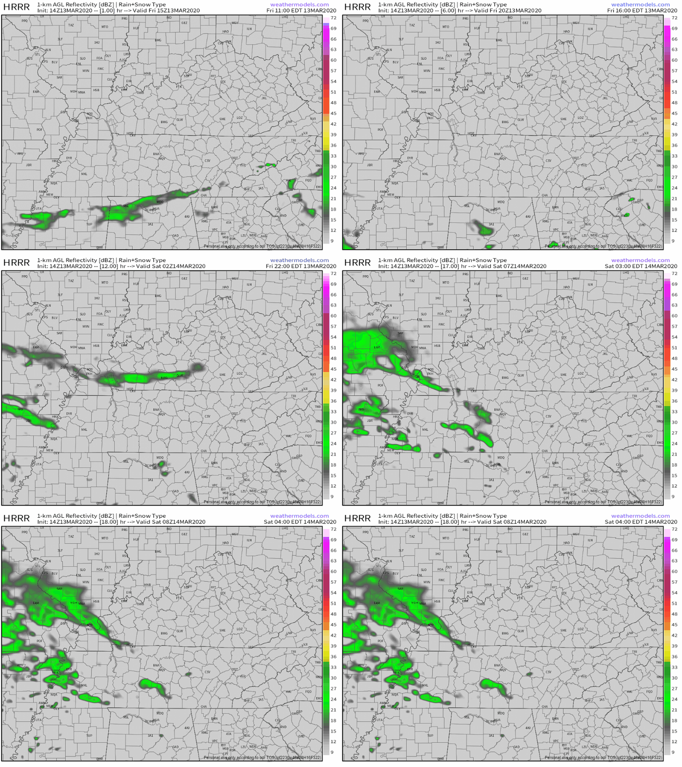
Near 60° for the high. We could see a few spotty showers into the late night hours and overnight into Saturday morning. Here’s the HRRR through 3AM

Saturday

Rain will move in early, between 5AM-7AM. Widespread rain will keep us soaked through the morning hours. We might get a bit of a break for the afternoon, a few hit or miss showers still sticking around, before more widespread rain moves in for the evening.. The NAM plans this out for us:

Sunday

Some of the rain will stick around for Sunday morning, but we should dry out and see a few peeks of sun for the afternoon. Still normal for this time of year for the high, 57°.

The NWS-Nashville explains this further:

“More rains move in late tonight as another in a long line of waves begin to affect Middle TN over the next week. 1 to 1.25 inches of rain is likely through tomorrow night. Fortunately, there`s no severe weather threat and I don`t see any need to mention thunder, either. That will be good for the ongoing clean up efforts. We should dry out Sunday and we might even see some sun by Sunday afternoon, too.”

NWS-Nashville Forecast Discussion 3/13/20

Rain Doesn’t Go Away For Workweek

No severe weather expect in the foreseeable future. Just rain. Temperatures hang around in the mid 60s and 70s all week.

Check back for more updates!

Dry Through Wednesday Evening, Strong Storms Possible Thursday, More Showers This Weekend

The Kids

From the Editor: We’ve heard from several who are in the process of healing from the tornado that came through our city. Thank you for sharing your stories with us. We read them all. We’re right there with you. One theme we’ve picked up on is that the kids are also going through processes of grief as well. Maybe your kids are. Below you’ll read about a low chance of severe weather in the forecast. We know, while the chance of severe weather is low, that will cause some concern among those (including kids) who are processing last week. Perhaps you’re looking for some resources to help guide your kids through what happened. Below are some links that came our way. We hope they help.

Parent Guidelines for Helping Children After A Tornado

After the Tornado: Helping Your Children Heal

Teacher Guidelines for Helping Children After A Tornado

Drying Out For This Afternoon, Some Rain Late Wednesday

The last bit of rain is pushing it’s way out of Middle Tennessee mid-afternoon ahead of a cold front pushing through. Here’s the HRRR:

Even though a cold front is moving through today, we’re not going to get much cooler. We’re up to 66° for the high, then temperatures drop into the low 50s and mid 40s by morning.

We’ll stay dry throughout Wednesday morning and afternoon, maybe a little bit of sun as well if we’re lucky, 66° once again for the high. A few showers will make their way to us around 11PM-1AM Wednesday night. The NAM illustrates that for us:

Storms Rolling In Thursday

More specifically, Thursday afternoon into Thursday night. Exact ETA’s are still up in the air. Here’s what we do know about Thursday’s storm potential.

We’ll be up to 72°, before a cold front pushes through, bringing the chance of storms. Forecast data still isn’t in agreement, but will become more accurate as we get closer to Thursday.

The Storm Prediction Center is giving us a 5% risk of seeing severe storms within 25 miles of you. The atmosphere will be unstable enough to support a few strong to severe storms, but the main threat the NWS-Nashville wants you to know about is the damaging winds and hail.

Image

Secure loose objects, tarps, and recovery equipment in case we get a storm or two on Thursday night.

[Editor’s Note: We know a forecast that includes any thunderstorms at all might cause some anxiety, maybe a lot. We have no reason to believe the weather on Thursday will produce a repeat of what we experienced last week. We are still a couple of days out. For now, continue doing what you’re doing to heal. We’ll keep an eye on Thursday for you. Check back tomorrow. We’ve got you.]

Rain Friday And This Weekend Still On The Table

Most forecast data is in agreement when it comes to Friday. Showers early, then drying off during the mid-afternoon. Cooler, but still pretty warm, 60° for the high.

However, model’s are not exactly in agreement when it comes to our rain chances this weekend. The Euro model is planning a washout for both Saturday and Sunday:

While the GFS is calling for rain most of the day Saturday, but not a complete washout for Sunday

Prepare for some wet weather this weekend either way. We’ll know more about ETA’s and better rain chances as the week progresses.

Sun Today & This Shortened Weekend (cold mornings), Rain Next Week.

Winds today gusting 15 to 25 MPH will make it feel a bit cooler than it actually is, even with the sun out. Winds will slacken off tonight.

Chilly mornings, though. Below freezing before dawn Saturday, near freezing early Sunday morning.

It’s going to gradually get warmer and feel even better out there Saturday and Sunday. We’ll be up to 55° on Saturday and then 65° on Sunday.

Yeah yeah yeah sure it’s Daylight Saving Time (no second “s” in Saving), sorry Mrs. Rich, my 7th grade English teacher.

Rain Returns Monday Night – Tuesday

First, no severe weather is in the forecast. The system coming through will be missing instability, a key severe weather ingredient. A few rumbles of thunder are possible in the afternoons next week but, again, there is no indication of severe weather.

Instead, it’s going to rain off and on. ETA as early as Monday night. Below is the GFS run from Monday morning through Friday morning:

As you can see, there’s plenty of rain coming for us through the work week. Rain will be off and on, most likely Tuesday and Wednesday night, but possible anytime from Monday night through Thursday.

Day 11 image not available

The Weather Prediction Center thinks, total, we’ll see rain of 1.5″ to 2.5″ late Monday through next Friday. Flooding is not a concern right now, but we will update this forecast tomorrow and highlight any changes.

Quieting Down Today, More Rain Thursday.

Editor’s Note: Love. Give. Comfort. Respect. Hearing about loss of life. Some families lost homes, students lost schools, workers lost businesses, there will be needs. Let’s meet those needs. Together.

Rain Pushing Out This Morning, Dry Rest Of The Afternoon

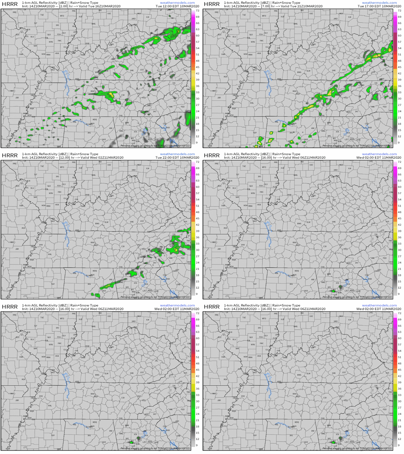
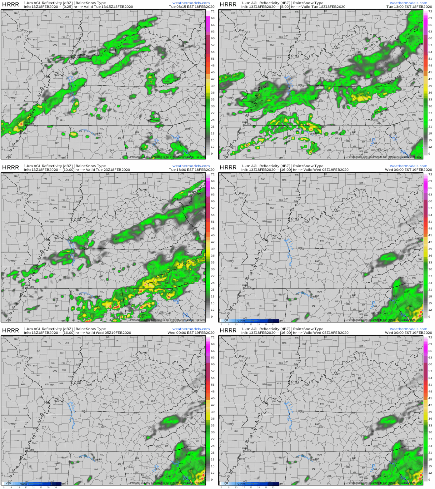
Rain is departing. Here’s the HRRR model:

No more storms Tuesday. Clouds will keep any peeks from the sun to a minimum, high of 66°.

Dry Wednesday, More Showers Thursday

We’ll get a bit of a break from the rain on Wednesday. Mostly cloudy, but most of us will still see a good amount of sun through the morning and afternoon. Above average temperatures again, high of 65°.

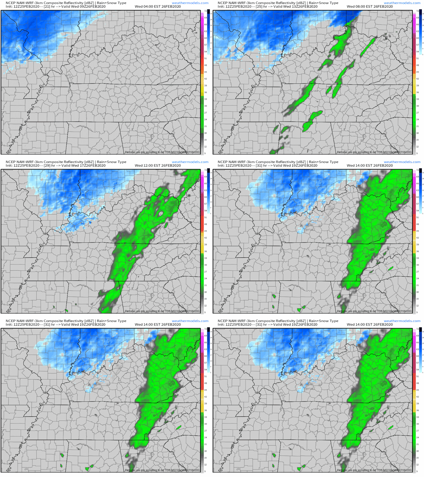
Thursday comes with more rain. Widespread showers will move in from the Southeast between 4AM-8AM, just in time to cause more traffic for the morning commute. Here’s the NAM through 12PM on Thursday:

No severe weather expected Thursday. The rain will continue to be widespread through much of the afternoon as well. We’ll cool off as the rain pushes through, high in the mid 50s.

Much Needed Good News..Dry And Sunny Weekend

Friday through Sunday the sun will hang around in Middle Tennessee and provide us with a pleasant weekend. Temperatures will go on a warming trend through the weekend.

High 40s for Friday, then warming up into the mid 50s for Saturday and low 60s for Sunday.

Check back for more updates as always and follow us on twitter @NashSevereWX.

Strong to Severe Storms Possible Tonight, More Rain Through Thursday, Dry And Cooler Weekend

Isolated Showers This Afternoon, Strong to Severe Storms Possible Tonight

We’ve gotten a break from the rain for a few hours this afternoon. Clouds will stick around, so not much sun there for us today, but regardless we’ll be up to 64° for the high. Strong to severe storms will move in from the west this evening. Here’s more on that from the NWS-Nashville:

“Latest guidance shows instability increasing later this afternoon, with MLCAPE values around 500 J/kg or slightly higher by 00Z. This instability looks to hang around through the early overnight hours, and combined with the strong deep layer shear, severe thunderstorms remain possible later today and tonight. The HRRR and other CAMs show thunderstorms developing just northwest of the area around 00Z, and spreading into northwest zones in the evening.”

NWS-Nashville 3/2/20

Instability is like fuel to the fire for thunderstorms when developing. The Storm Prediction Center has us under a 15% chance of seeing severe storms within 25 miles of you.

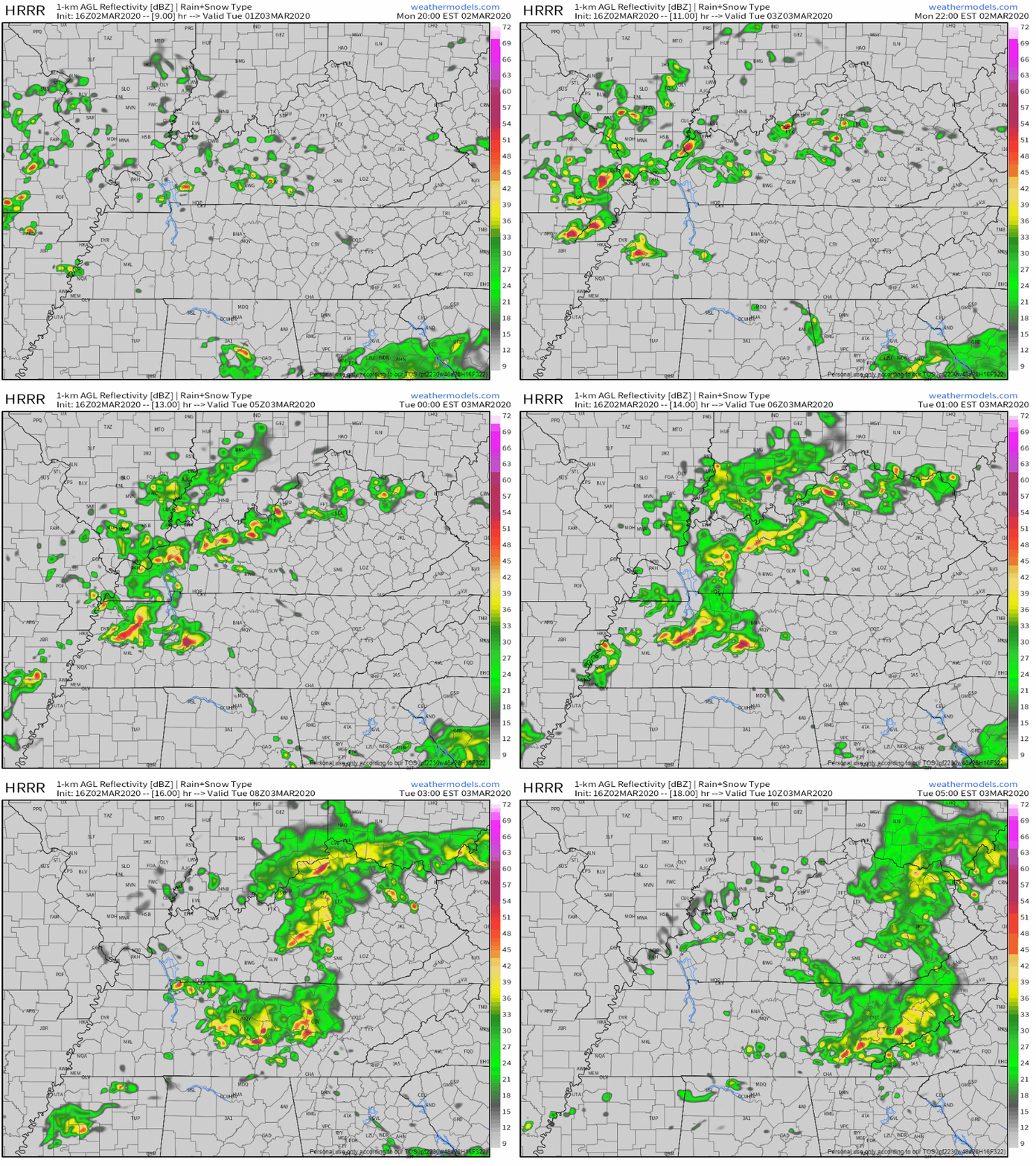
Here’s what the HRRR believes the next several hours will look like. Loop through 4:00 am.

Notice a few splotches of red and yellow signifying the heavier rain and storms.

Timing

The stronger storms will begin to move into our area between 11PM-1AM, and eventually moving to our east overnight as the instability drops off. Rain will become more isolated once the stronger storms pass through.

Threats

With the small amount of low-level shear, tornadoes aren’t going to be a primary threat, but still cannot rule one out. The main threats will be potential damaging winds and hail. The NWS-Nashville goes into more detail:

“With mid level lapse rates still pretty steep along with the drier air in that layer, hail remains the primary threat, with damaging wind gusts also possible with any strong to severe thunderstorms. Low level shear is on the weak side, however, can not rule out an isolated tornado especially if low level shear picks up this evening.”

NWS-Nashville Forecast Discussion

[Editor’s Note: Notice the “if.” If shear increases the tornado threat will go up from where it is now. Don’t disconnect from future revisions to this.]

[Editor’s Note: Don’t go to bed “unplugged” tonight. Have multiple ways to get warnings including a wake-me-up app.]

More Rain For Tuesday Through Thursday

Yes I said rain, and that may make you a little sad. The good news is that it’s not going to rain all day every day until Thursday. Tuesday’s rain will move in early morning, last us through the morning commute and into the early afternoon, before moving out and leaving us cloudy, but dry and 65°. Here’s the NAM illustrating this out for you:

Wednesday we’ll see a few what I like to call “splash and dash” showers before they become more widespread overnight. High of 62°. Thursday you’ll still want to have that umbrella or rain jacket with you when you head out the door, but not a complete washout. Here’s the GFS for Thursday:

By the time all of this moisture has moved out of Middle Tennessee, we’ll rack up 0.5-1″ of rain.

A Peek Into The Weekend

We’ll be cooler this weekend, but the good news…no rain! Highs will be in the mid 50s to low 60s, and plenty of sun to go around for all of us.

nashville predators hockey GIF by NHL

Inconsequential Rain/Flurries Tonight, Nice Weekend, Heavy Rain/Flooding Concerns Next Week

Flurries Are Gone, But Cool Weather Continues

Up to 46 this afternoon with sunshine.

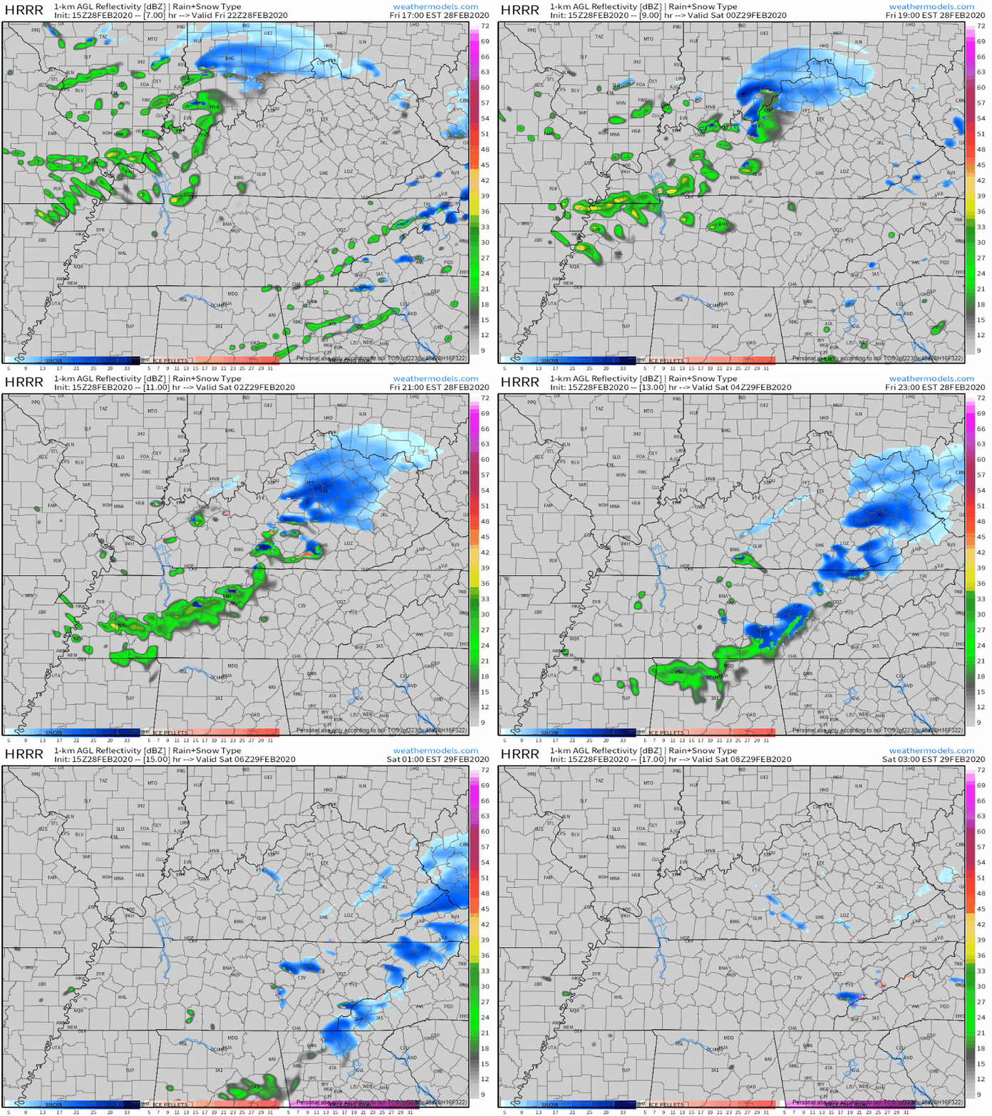
But to our NW another batch of precip is en route, ETA 7-9 PM. Here’s the HRRR model predicting rain with a few snow flurries around midnight:

No meaningful accumulation expected except maybe at the highest elevations. It may not even snow (it could just be rain).

Warmer, Sun This Weekend

The sun will stick around providing us with a pretty nice weekend. All sun on Saturday, still a bit cool, high of 50°, but by Sunday temperatures increase all the way into the mid 60s, with a few more clouds.

Perfect weather for you to come on out on Saturday and meet all of us at Nashville Severe Weather and our interns at SWAD 2020 at Trevecca Nazarene University on Saturday!

Enjoy the beautiful weekend ahead, because we have a LOT more rain in the forecast for next week.

overjoyed so excited GIF by Demic

Heavy Rain Monday through Thursday, Flooding is a Concern.

Rain will begin to move into Middle Tennessee late Sunday night. It’ll come in waves Monday, Tuesday, and Wednesday, heavy at times. The GIF below is from the GFS model, showing us almost nonstop rain, heavy at many times, through Wednesday night.

How much rain are we talking?

Well, a lot. The Weather Prediction Center’s QPF values are worrying, especially Tuesday, when flooding concerns begin.

Monday night to Tuesday night: 1.5 to 2″

Day 4 image not available

Tuesday night through Wednesday night: an additional 2-3″:

Day 5 image not available

Wednesday night through Thursday night, another 0.10-0.5″.

Day 6 image not available

The NWS-Nashville is calling for 6-8″ of rain total through Wednesday. This coming down in a 3 day period can cause many flooding issues and is concerning. The majority of this will come down on Tuesday and Tuesday night alone, so keep in mind to have a way to get your warnings for any Flash Flood Warnings that might be issued, especially near any rivers and creeks.

Check back for more as we get more information over the next couple days regarding the heavy rain and flood risk coming for us next week.

han solo salute GIF

NashvilleSevereWeather.com/shop & Subscribe to our YouTube Channel.

Dry And Cloudy Today, Temperatures Falling Wednesday With Chance of No Worries Flurries

Staying Dry Today, Pleasant Temps

We’ll steer clear of the rain today. It’ll be mostly cloudy, but the sun will still peak through a few times. Slightly above average temperatures this afternoon and for the high, 57°. A couple showers are possible moving into the evening, but most of us will stay dry tonight.

approve always sunny GIF by It's Always Sunny in Philadelphia

Turning Colder Wednesday, Rain to Light Snow Mix Possible Overnight

Our high of 47° Wednesday is going to come in the morning before temperatures begin to drop through the rest of the day as a cold front moves through Middle Tennessee before the afternoon rolls around.

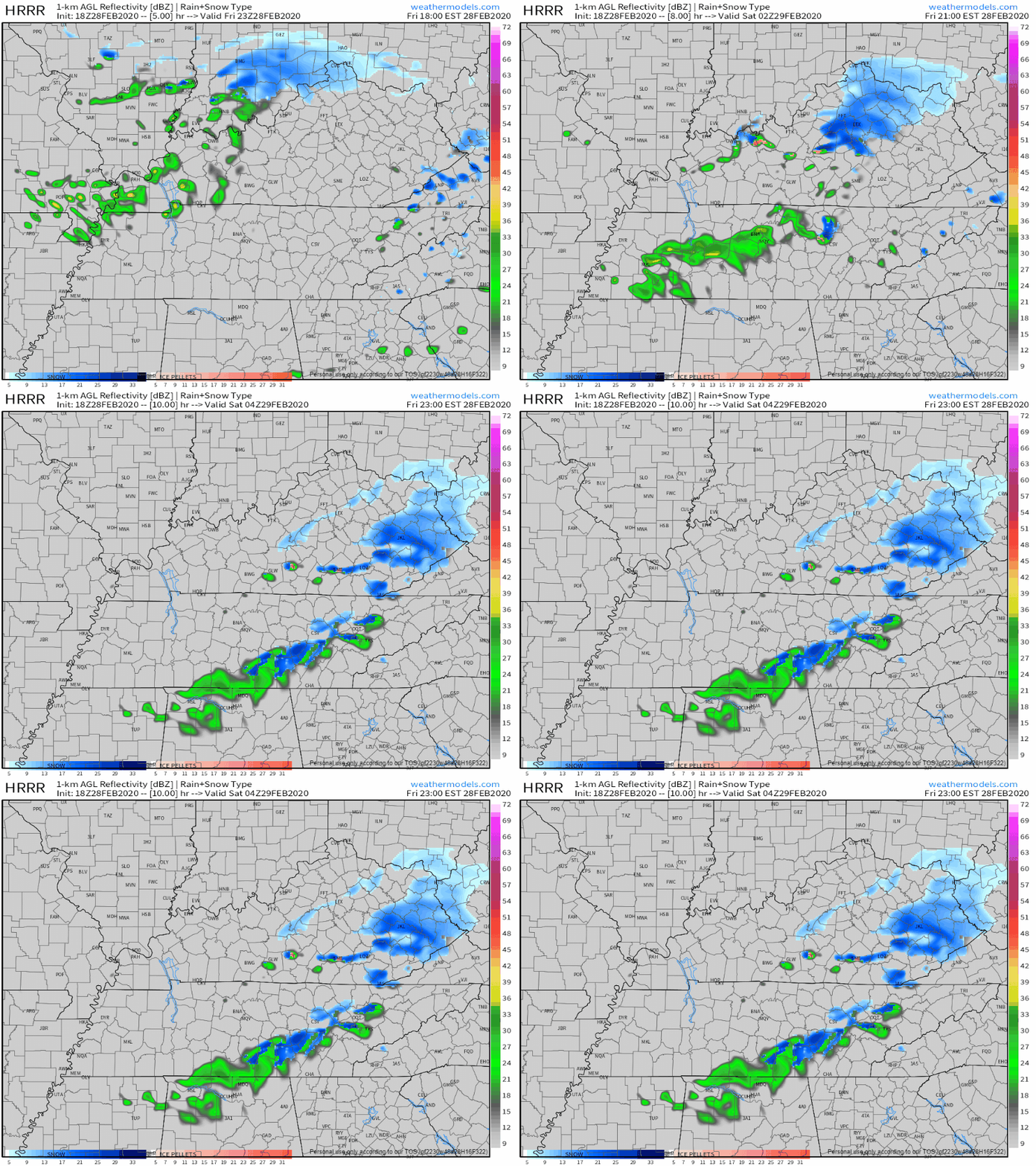
Keep your umbrella handy for the morning commute, the NAM3 model has a line of showers moving through between 7AM-8AM and lasting on and off through early afternoon:

By the time the evening rolls around, most of the moisture will be east of I-65, and as temperatures continue to drop, a rain/snow mix after 7PM is possible, but most of it will be off to our East. Here’s the NAM again:

No accumulation or travel impacts are expected in Nashville, but more likely with our friends on the Plateau.

The most Nashville will see if just some flurries and flakes, but nothing on the ground. Temperatures will still be above freezing as the snow chance is at it’s greatest, and roads and surfaces will still be too warm for much of anything to stick.

Nam 3km model Wednesday night. Nam 3 also has us sub-freezing for a few hours near sunrise Thursday morning.

Much Cooler And Dry Thursday And Friday, Couple Flurry Chances Overnights

The sun stays with us on Thursday and for Friday, although it’s going to be much cooler, so don’t let the sun fool you too much. A high of 44° on Thursday and 45° on Friday will keep us honest, so be sure to carry your coat with you for any plans.

So what about this snow flurry talk for the end of the work week?

The GFS thinks that early Friday morning will be our best chance to see a few flakes:

The Euro model thinks so as well, with some flurries possible for the early morning commute. Exact ETA’s are still too uncertain with these long range models a few days out.

Either way, don’t expect much of anything accumulation wise. Temperatures will be hanging close to freezing, which is how and why we have a chance of seeing some flakes, but the roads and surfaces will still be too warm, along with lack of moisture, to put much if anything on the ground.

Check back for more updates and follow us on twitter @NashSevereWx!

Rain Today, Dry Tomorrow, Showers Wednesday And Cooler Temps To End The Work Week

More Rain For Monday

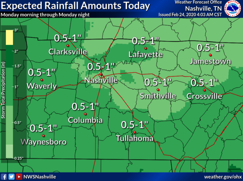
Another start to the work week and another dreary rainy day. Showers will persist with us throughout the majority of the day and this evening. No flood concerns, but still a decent amount of rainfall by the end of the day.

Just under an inch of rain is expected for most places, some locally higher and smaller amounts as well. Some instability in the atmosphere will allow a few rumbles of thunder this afternoon and evening, nothing severe. Here’s the HRRR model:

Hold on to your hats if you’re going out later this evening as well

“Showers will decrease in coverage after 10 PM. Afternoon temperature will be mostly lower 50s with south breezes up to 20 mph at times.”

NWS-Nashville Forecast Discussion 2/24/20

Dry On Tuesday, More Showers Coming Wednesday

We’ll see a bit of sun between some breaks in the clouds on Tuesday. The good thing is, we’ll stay clear of rain. Near average high temperature of 58°, and not a bad afternoon to go out for any plans.

Text Emoji GIF

Wednesday comes with our next chance of showers. Model data is still coming in as we approach Wednesday, so here’s the NAM through 6PM Wednesday:

You’re going to need to keep the umbrella handy heading out the door for the morning commute on Wednesday, but the rain pushes off to the East by the early afternoon.

The GFS agrees, rain exiting early in the afternoon, maybe a couple of snowflakes mixed in well to our east Wednesday night into Thursday morning:

Temperatures will drop as the rain moves in, 44° for the high Wednesday. Winds will ramp up a bit as well, gusting up to 20mph.

Ending The Work Week With Sun

Don’t let the headline mislead you too much, yes it’ll be sunny, but also pretty cool as well.

Temperatures are going to struggle to get into the mid 40s for Thursday and Friday, even though the sun will be out. Not bad for afternoon/evening plans, but take a coat with you as you head out the door to end the week.

cold GIF

Check back for more updates and follow us on twitter @NashSevereWx!

Sun Is Out Today And Tomorrow, More Rain Coming For The Workweek

Cool And Sunny Today, A Bit Warmer Tomorrow

All in all, not too bad of a day weather wise. There will be plenty of sun to go around this afternoon, although it will be cool. Only up to 43° for the high.

sun GIF

Saturday comes with more sun and a bit warmer temperatures. Closer to average for this time of year, 53° for the high. We’ll continue the short-lived dry trend through Saturday as well.

Rain Returns Sunday

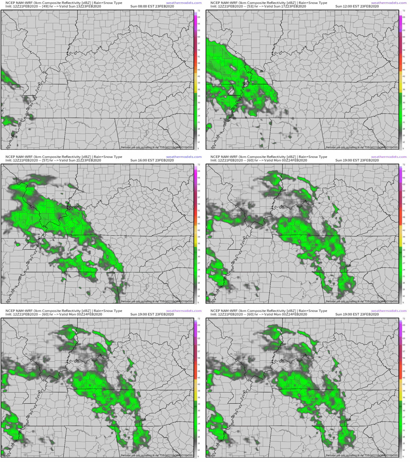
The first half of Sunday we’ll still be dry, but it won’t last forever. Here’s what the NAM3k has for us so far:

ETA’s will become more apparent over the next 24-36 hours, but for now the rain looks to be moving in sometime after 1PM, allowing the perfect set up for a Sunday afternoon nap. Temperatures will remain in the mid 50s through the rain into the evening.

More Rain For The Work-week

Monday and Tuesday will come iwht more of what we’re all getting tired of hearing…rain. Monday will likely be a washout with widespread rain and a few rumbles of thunder here and there. Here’s the GFS:

I’m not going to try and forecast exact ETA’s with a long-range model like the GFS, but prepare for a wet one on Monday. Temperatures still hanging on in the mid 50s.

Tuesday the rain won’t last forever, but you’ll likely need your umbrella/rain jacket when you head off to work in the morning.

mad stop motion GIF by Headexplodie

Through Tuesday we could receive 0.5-1″ of rain, so flooding isn’t a huge concern, but the forecast totals will likely change through the weekend.

Day 10 image not available

Where Are We With Rain This Year Compared To Average?

If it seems like it’s rained a lot more than normal so far this year, then you’d be correct. This far through the calendar year we average around 6.7in of rain. So far this year, we’ve already accumulated 11in of rain at Nashville International Airport.

With more rain in the forecast, we’re not dropping to average anytime soon.

Check back for more updates and follow us on twitter @NashSevereWx!

More Rain Today, Dry Tomorrow, Splat/Melt Flakes Possible Thursday

Another Rainy Day Today, Dry For Wednesday

I’m not saying today is going to be a complete washout, but you’ll definitely need the umbrella off/on for sure. Showers will continue to move in from the west into this evening. 62° for the high. Here’s what the HRRR believes will happen through 11:00 pm tonight:

Most of the heavier rain will remain South of I-40, but some of us could see a few of these heavier showers. It’s going to be a bit of a windy night as well, gusts up to 25 mph.

Wednesday

Any showers leftover from Tuesday will push off to our east overnight and before we wake up on Wednesday. The sun will peak through the clouds every once in a while, but we’ll still be much cooler, 49° for the high.

bother mother nature GIF by joonasjoonas

Splat/Melt Snow Possible Thursday

Rain moving in from our southwest could turn into some snowflakes Thursday. Here’s the NAM:

The Euro isn’t really buying into it as much

Neither is the GFS..

A few of the models aren’t buying into much, and that could be for good reason.

This is setting up to be another one of those let-down “snow/splat” situations. Rapid temperature drops between the 1000mb and 850mb levels of the atmosphere are why we could see some snow falling, but nothing much is going to stick.

Why? It’s simple, the ground temperatures are going to be too warm. Surface temperatures will be near, but mostly above freezing when the snow potential is at its highest, then temperatures will continue to rise above freezing as we progress into the late morning hours.

disney frozen film GIF by Walt Disney Animation Studios

Early Peek Into The Weekend

Friday and Saturday will be cool, highs in the low 40s and low 50s. The good news is no rain in the forecast and the sun will be out and shining.

That is…until Sunday, when, yes, more rain moves in to end off the weekend. Temperatures still in the low 50s.

Also don’t forget Severe Weather Awareness Day here in Tennessee is on February 29th! Come see us at the Boone Business Building at Trevecca University. Our interns will be in town as well!