It is definitely going to feel like winter out there today. Grab your hats, scarves, fuzzy socks, and gloves cause it is capital C Cold today. Temps will be in the 20s and 30s. This combines with the wind coming from the north, giving us some wind chill values in the teens. Here’s what that looks like on the HRRR. Blue is very cold, purple is very very cold.
Month: January 2022
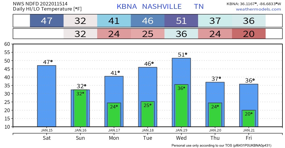
Chilly and Dry Weekend Ahead
All the wintry stuff is well east of us by the time you are reading this. Now we are just left with the cold.
It is COLD out. The high temp today is expected to get up to freezing. If you take wind chill into account it’ll feel like it’s in the teens. The extremely blue and purple image below better illustrates this.
Showers Today, Wintery Mix Possible Tonight
A line of rain has arrived. No severe weather/flooding concerns. Can’t rule out an isolated thunderstorm here or there, but most will see just showers.
Showers transition into a wintry mix late tonight as temps dip to at/below freezing. Models are in pretty good agreement as far as precip type/accumulation goes. Not much more than a dusting expected for our area (less than a half inch).
Freezing Fog Advisory till 9; Wintery Mix Wednesday? Maybe
Freezing fog has already formed early this morning. A dense freezing fog advisory is in effect until 9am this morning. Some extra time for your morning commute may be needed. Patchy black ice is still a road hazard to look out for this morning. Overpasses, areas of elevation and neighborhood/back roads can have hazards stay around longer due to slower melting. Temps get up to the high 40’s today so significant melting is on the way as we go throughout the day.
Rain to Snow System Wednesday.
Temps get up to the mid 30’s today. Melting will be slow. Expect a refreeze tonight as temps dive into the low 20’s. This may continue dangerous road conditions into the morning commute tomorrow, especially in elevated areas and on secondary/neighborhood roads. Highs tomorrow in the upper 40’s will bring significant melting.
Transition to Snow, Variable Accumulation, Freezing/Travel Hazards Tonight/Overnight
Slightly Warmer Surface Temps Have Entered The Chat. Winter Storm Warning Update on Highly Variable Forecast.
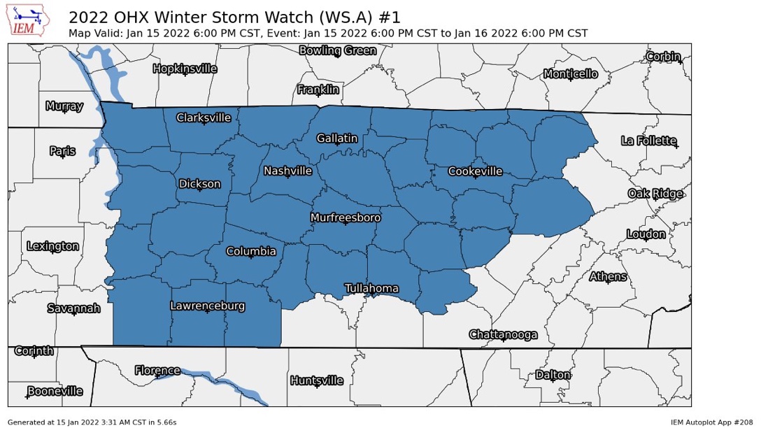
Winter Storm Watch, But The Forecast Remains Highly Variable.
The Winter Storm Watch begins for all of Middle Tennessee tonight at 6 PM and ends Sunday at 6 PM.
Looks like rain today will pause for a few hours then resume tonight. Overnight into early Sunday morning it should changeover to a wintry mix, then snow. The snow will be a wet, heavy snow. Somewhere in Middle Tennessee it could lay down snowfall rates around 1″ to 2” an hour.