
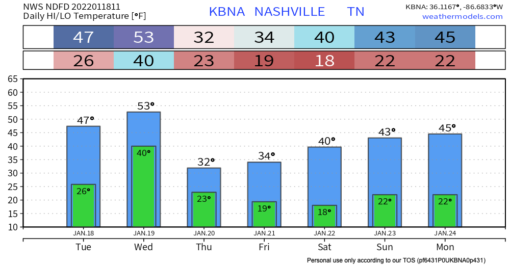
Freezing fog has already formed early this morning. A dense freezing fog advisory is in effect until 9am this morning. Some extra time for your morning commute may be needed. Patchy black ice is still a road hazard to look out for this morning. Overpasses, areas of elevation and neighborhood/back roads can have hazards stay around longer due to slower melting. Temps get up to the high 40’s today so significant melting is on the way as we go throughout the day.
Wednesday we continue to warm up to the low 50’s. If there is still any moisture or mush on the ground, it’ll definitely be gone by tomorrow.
Any Fluffy Stuff for Hump Day?
Enjoy the warm(er) temperatures mid-week because a cold front comes in Wednesday evening bringing below average temps in to the weekend. Of course, showers also tag along. These showers start Wednesday morning. No severe weather is expected with this system. Isolated thunderstorms could be in the mix especially as a more pronounced line begins to form later Wednesday afternoon.
A wintery mix may be at the backside of this frontal passage. The temperatures are there but the amount of moisture to support a wintery mix is in question. See NWS discussion below:
Some moisture is expected to remain in area behind frontal passage, but how much moisture and how fast cold air can catch up to it, if at all, will determine how much of a wintry mix mid state may receive along with possible accumulations. Current GFS model run advecting moisture out of mid state quickest with current NAM/ECMWF much slower, especially ECMWF.
HRRR model below has scattered wintery mix starting around 9pm. The fluffy stuff comes later Wednesday night. Never looks heavy, just a dusting for Nashville if any.
Temps never get above that freezing mark Thursday. Any moisture on the ground from the rain event Wednesday could cause patchy black ice Thursday.
Some weather apps may have a snowflake emoji for Friday. Snow showers are possible east of I-65 but the models have it missing our counties. It is still pretty far out to have any confidence/clear answer. Stay tuned for updates.
Quick References:
Weather changes constantly.
Follow @NashSevereWx on Twitter for any changes to this forecast.
Live coverage during tornado and severe thunderstorm warnings:
Look good.
Support the mission.
We are 100% community supported. No ads. No subscription fees. Keep it free for everyone.
Categories: Forecast Blogs (Legacy)
You must be logged in to post a comment.