Winter Storm Watch Friday, Major Travel Impacts Likely Starting Friday Morning Possibly Lasting Into The Weekend

Headlines:

  • A Winter Storm Watch is in effect from early Friday morning thru late Friday night.
  • This will likely soon be upgraded to a Winter Storm Warning due to confidence continuing to increase.
  • Major travel issues likely start Friday morning, lasting throughout the day.
  • 3-7″ of snow possible, 3-5″ most likely as of right now.

Let’s dive into the details. Forecast could change! Stay connected for updates.
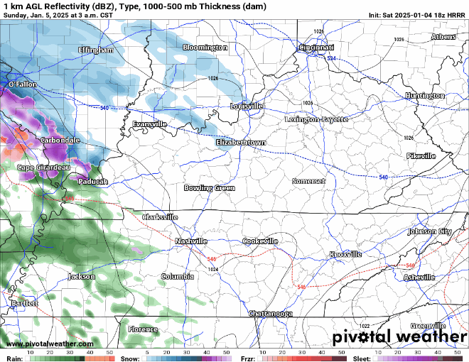
⏰Timing

ETA of snow is expected sometime between 4a and 10a Friday, most likely around 7a Friday.

Snow will likely stick around for the majority of the day Friday. Snow should stop sometime Friday night; best guess right now would be 7-10p. read more

Winter Weather Advisory for Davidson County; Light Freezing Rain Possible Sunday Morning, On/Off Rain Sunday Afternoon/Evening

A Saturday Evening update from our NWS added Davidson County to the Winter Weather Advisory that had previously been confined to counties north of us.

While impacts appear to be confined to Sunday morning, these impacts could cause car accidents or slip/fall injuries. Sidewalks, roads (particularly bridges and overpasses) may briefly become slick. Be prepared to take it slow on the roads Sunday morning. You may not encounter any ice, but better safe than sorry. read more

Cool But Dry NYE Night, Looking at Our Next System Coming Early Next Week

Some light showers possible tomorrow (Tuesday) during the AM hours, but these are expected to be few and far between and mostly staying to our north – HRRR model gives its best guess below.

Temperatures Tuesday afternoon will be in the low 50s but will fall to the low 40s with a decent NW breeze overnight. If headed out for New Year celebrations, layers will be your friend. read more