
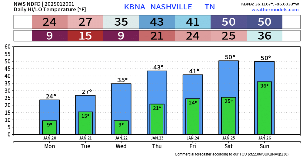
We are back to near average temperatures, and we’ll stay there for the remainder of the week – even getting above average several days. We’ll get a break from freezing temps for at least a little bit starting Thursday/Friday.

We are back to near average temperatures, and we’ll stay there for the remainder of the week – even getting above average several days. We’ll get a break from freezing temps for at least a little bit starting Thursday/Friday.

The Dry Air Monster is eating most of the moisture right now, but it will eventually get full, and we’ll see some showers overnight. HRRR model demonstrates how it might go down.
You might see a few flurries if you wake up early enough Monday morning, but no accumulation is expected. Most of the activity should be outta here by Monday AM commute time. Rainfall totals generally 0.25″ or less.

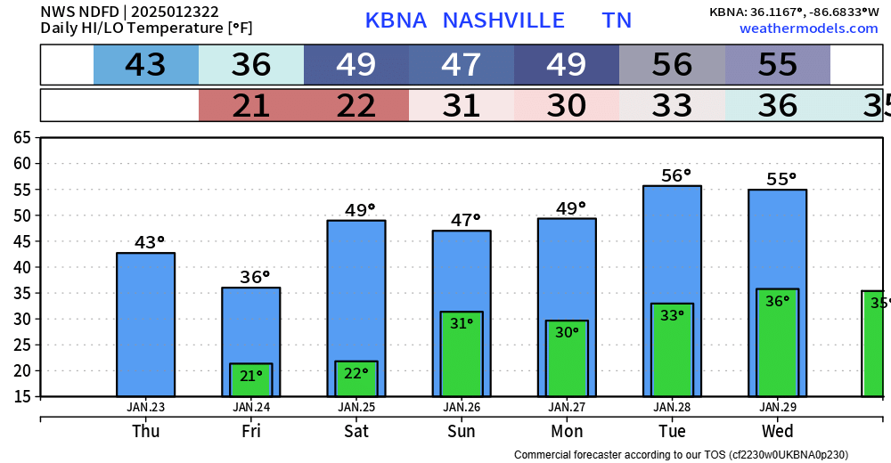
We are finally back in the 50s – the first time we’ve been this “warm” in 7 days. Only the 7th day this month we’ve seen 50°, it’s been a cold one.
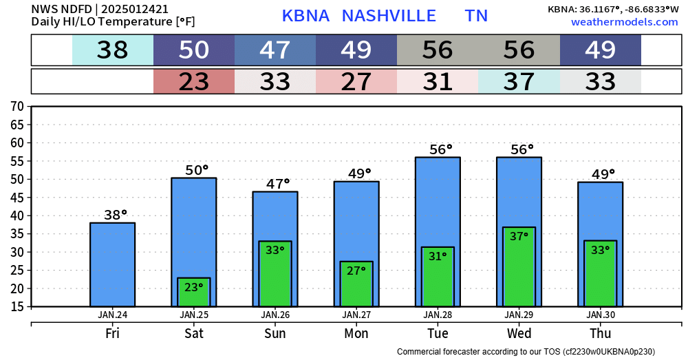
Temps will be fairly consistent over the next week or so. Right around average for this time of year, with the exception of Tuesday and Wednesday.
We’ve been below average for the majority of the start to January. If it seems like every morning has been cold, you’d be right on.
We’re finally getting back towards average for this time of year (highs upper 40s, lows around 30°), and we’ll even get above average by next week.
You might see a few flurries tonight – these would be no-worry-flurries, no accumulation expected.
Temps tonight/tomorrow morning will still be cold, just not as cold. We’ll bottom out around 20° for the next 2 nights.
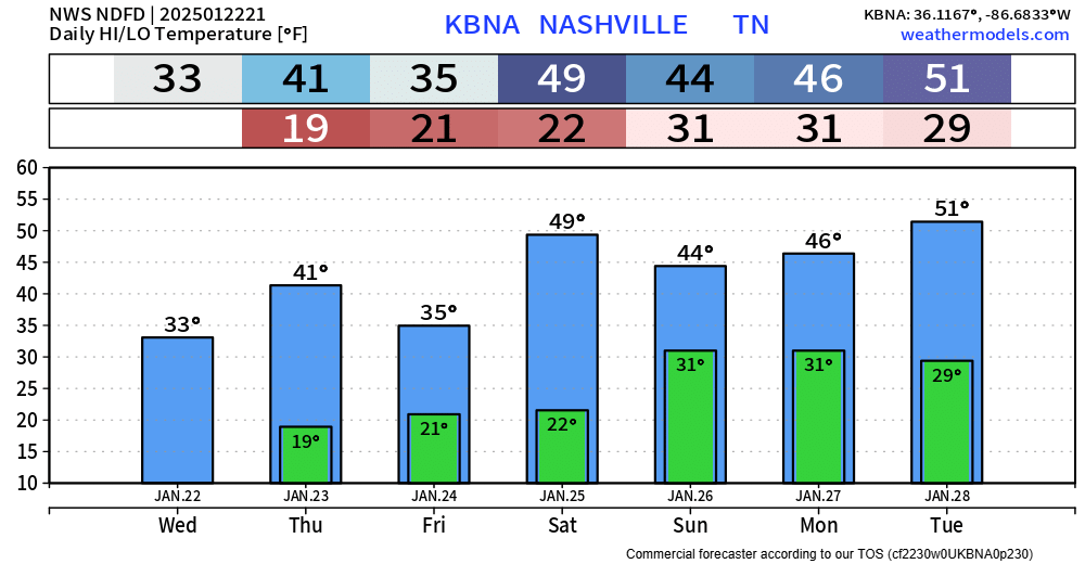
BNA briefly made it to 33° around the 3 o’clock hour, but a lot of other places stayed below freezing. Nashville spent 82 consecutive hours at or below freezing, but the clock may still be running at your place.
Another night of very cold temperatures.
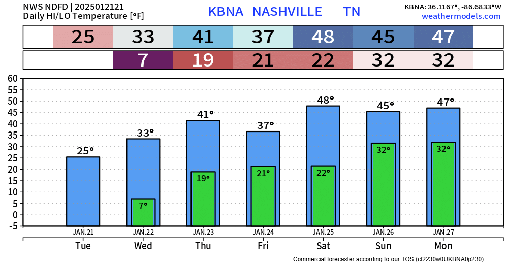
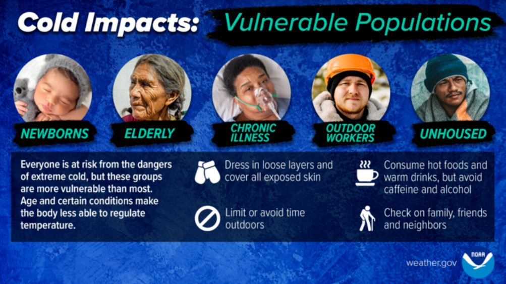
The official low for Nashville is 7°, but many locations outside of Nashville will likely see temperatures closer to 0°.
Thankfully, winds will be fairly calm, so wind chill values will be very close to the actual air temperature. Regardless, it’s still going to be downright cold.
Although we won’t get as cold as last night, it’ll still be very cold tonight.
Official low for BNA is 15°, local backyards may be closer to single digits. Winds will be calmer tonight, so wind chill values won’t differ much from actual air temperatures.
Temps will plumet tonight.
Monday morning, most of us will wake up with temperatures in the single digits, with wind chill values (“feels like”) as low as -5°.
Thus, we are under a Cold Weather Advisory from now until noon Monday.

Temperatures are beginning to fall and will soon dip below freezing. If the forecast holds true, they will not rise above 32° until around 10am Thursday morning. That’s about 104 hours at or below freezing. Your mileage may vary.
You must be logged in to post a comment.