Nice Weekend!

Current Radar

Sunday – Another Dry Day for Us High: 92°

High pressure will continue to dominate and no showers are in the forecast for Sunday!

Winds will begin to shift out of the south. We will begin to warm up into the mid 90s.

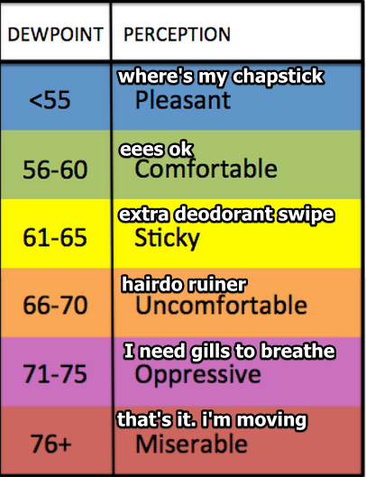
Dew point will be in the upper 50s. It’s looking like a good hair day! read more

Very Hot Today & PM Storms

Current Radar

THIS EVENING – 76° by 7 PM 

Another cluster of non-severe thunderstorms looks to be making its way south from Kentucky. If the storms hold together, we may see them within an hour or so.

As things keep cooling off this evening, shower/storm activity should begin to diminish, especially after the sun sets (7:55 PM): read more

Tread Lightly Tuesday

Current Radar

Tue 95°, Wed 94° Oppressive Humidity, Small Rain Chances

Today dewpoints in the low 70°s will hang around Tuesday and Wednesday.

It’ll remain awful out there. The heat index (“feels like”) temp will range between 100° and 105° Tuesday and Wednesday. read more