
Current Radar
Tue 95°, Wed 94° Oppressive Humidity, Small Rain Chances
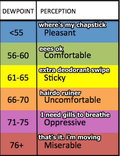
Today dewpoints in the low 70°s will hang around Tuesday and Wednesday.
It’ll remain awful out there. The heat index (“feels like”) temp will range between 100° and 105° Tuesday and Wednesday.

Planning on something outside?

Each day, there’s a low chance for “heat of the day” thunderstorms. Just like today, high pressure was stamping down on the rising, humid air.

Thursday: A Cold Front!

Models agree: late Wednesday night or early Thursday morning, a weak cold front stretching all the way from eastern Canada will show up, setting off rain and maybe a few not-worried-about-it thunderstorms.
So, this?

Not quite. High temps through Friday through the weekend will knock our temps only down to around 90°, but the oppressive humidity will be gone. This should set up a typical summer weekend for the first of August.

This website supplements @NashSevereWx on Twitter, which you can find here.
Categories: Forecast Blogs (Legacy)