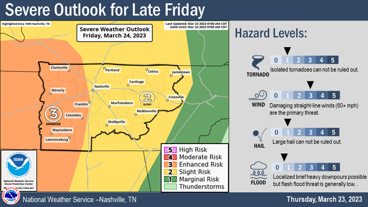
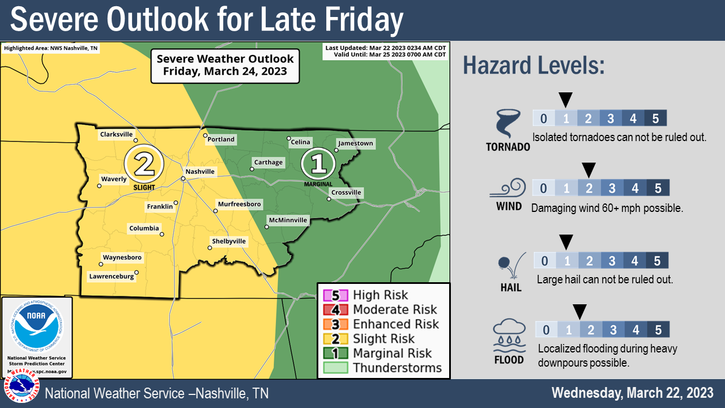
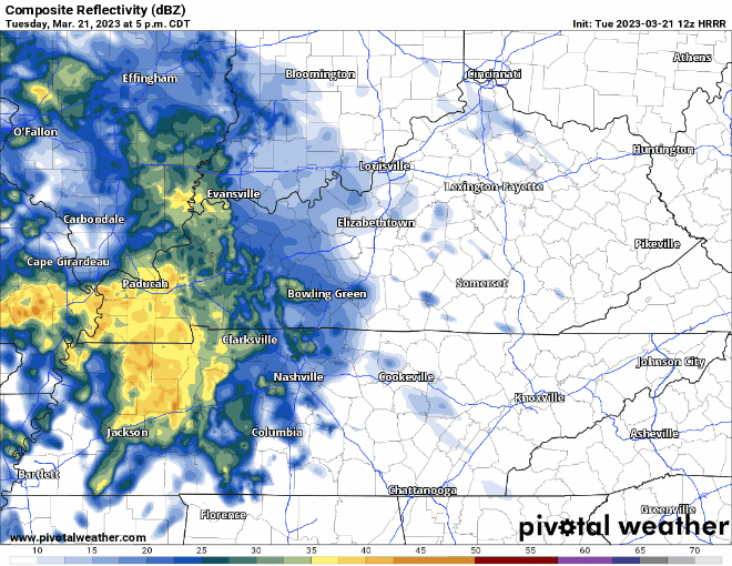
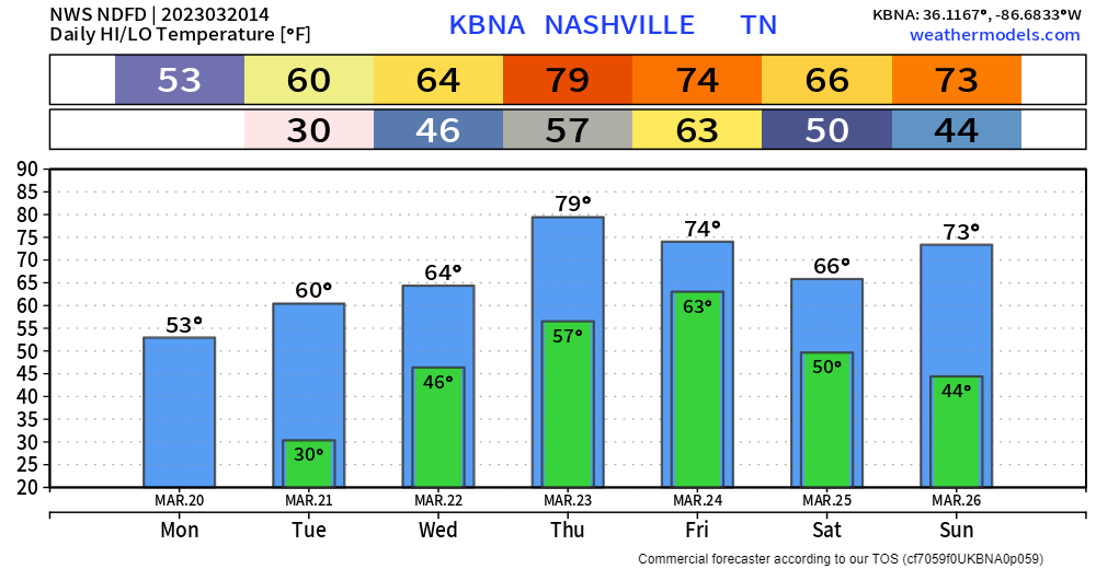
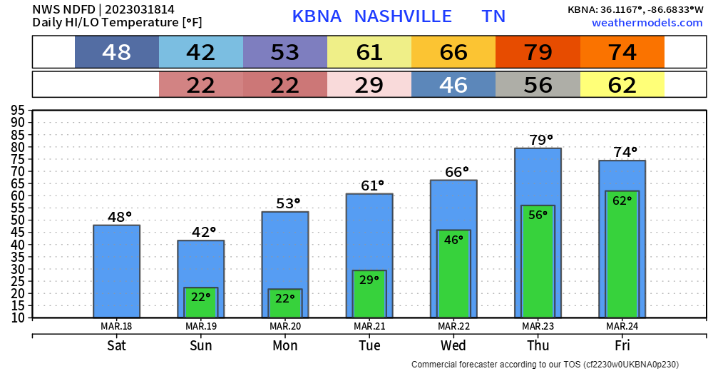
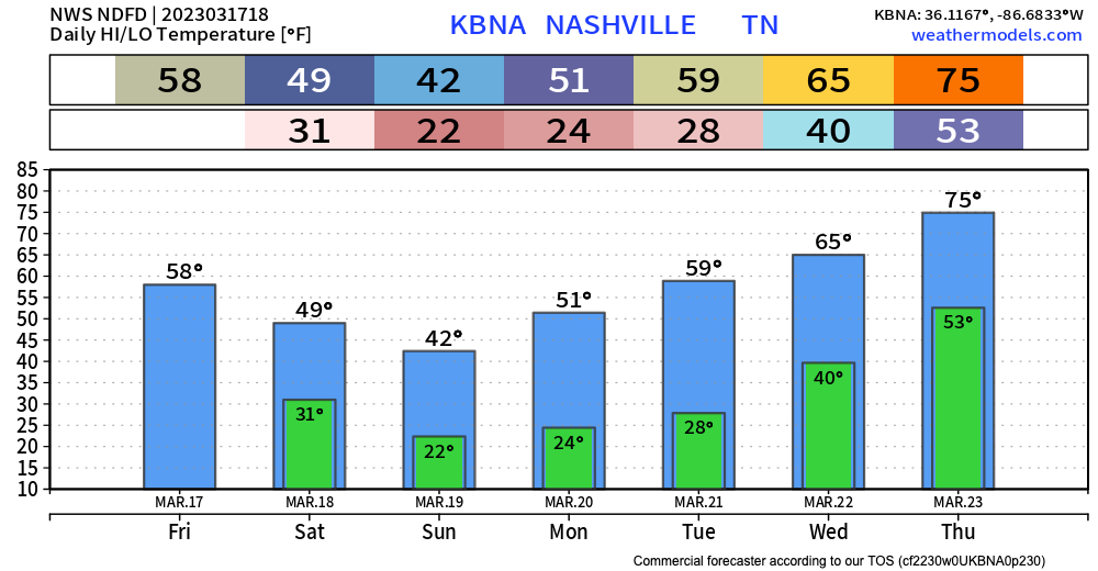
The flizzard is over!

All in all we picked up 0.0″ of snow and 0% of us lost power. Winning!
TODAY… Temps will be in the lower 40s and after the cloud deck moves out, the sun returns. It will be a welcome sight.
The flizzard is over!

All in all we picked up 0.0″ of snow and 0% of us lost power. Winning!
TODAY… Temps will be in the lower 40s and after the cloud deck moves out, the sun returns. It will be a welcome sight.
Sorry snow lovers, but you’ll only get to look at the snow falling today. We comfortably sit above freezing and will stay that way all day (until tonight, but snow will stop before that). No impacts are expected. Head to the Plateau for snowman building.
The Storm Prediction Center has our counites outlooked with a:
Main threats today are large hail and damaging straight-line winds. Golf ball sized hail, and some larger, has already fallen in Kentucky this morning.
Minus the clouds and maybe occasional shower or drizzle, today won’t be too bad with highs in the mid 60’s.
Tomorrow the Storm Prediction Center has outlooked both of our counites with:

Models aren’t doing the best job of agreeing on this. The latest run of the HRRR model thinks the majority of the storms completely miss us tomorrow and we get away with maybe just some rain. Meanwhile, a couple other models disagree and think storms, possibly severe, do impact us.
Fairly nice day today and tomorrow, highs near 60°. Maybe some drizzle throughout the day Wednesday.
For Thursday, the Storm Prediction Center has outlooked our counites with a 5% chance of severe weather within 25 miles.
Boring weather for the next few days. Temps will warm tomorrow to around 60º. Same on Wednesday. This is great! It would stay great except there is a chance of rain and thunderstorms Wednesday night and Thursday. There’s a small chance for some isolated overnight showers Tuesday night, but this seems very insignificant.
We’ve picked up vary amounts of rain the last 36 hours. Most of that rain is moved off to our east, but we will see drizzle cloudiness for much of today. A bright spot is the temperatures which are hovering around 50 at present and might get up to 55 later. Higher still if we can get a bit of sun.
Note: Today is the first Saturday of the month, so you can expect the usual tornado siren tests in Metro at noon and Williamson County at 1:00 pm. With today’s rain, they may opt not to test, but if they do, that’s what’s up.
We have two opportunities for rain in this forecast. One begins early tomorrow morning and ends sometime Sunday. The other comes late next week, say Thursday.
Early tomorrow morning, showers should be approaching us. Initially, the rain will be light and scattered. The rain will likely fill in at various times and drop periods of moderate rain. It’s hard at this juncture to pin down exactly when the more solid rounds of rain will come through. If you have outdoor plans, just keep an eye on radar. https://nashvillesevereweather.com/radar/
It’s a bit of a relief to not have much to write about. No severe weather with this forecast and no flood threat. Just….the usual.
A window for rain chances opens Friday night and closes Sunday morning. Rain chances are fairly low each day, and total rainfall amounts through Sunday night are expected to be wellll below half an inch, maybe not even a quarter inch, according to the blend of models. This could change. But, this is what we’re aiming for as of today.
You must be logged in to post a comment.