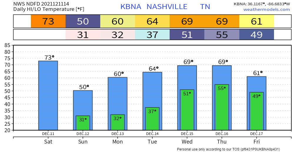
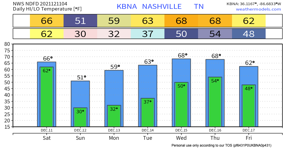
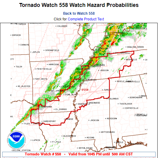
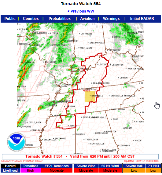
NWS-Nashville is out surveying storm damage. Yesterday they rated the Dickson tornado EF-2, entire path length not yet determined. Early this morning they rated the Kingston Springs tornado EF-2, 125 MPH maximum wind, 400 yards wide, 10.5 miles long, 1 injury. Surveys will continue today. We will tweet updated information.
Category: Forecast Blogs (Legacy)
Much Needed Calm Weather

We are all done with rain and severe weather. If you are waking up to any damage, tweet a picture of it with the location using #tspotter. Storm surveys will be conducted again today to determine where we had tornadoes vs. where we had straight line wind damage. We will tweet updates as that information comes in.
Storms Gone, What’s Next: Colder.
Tornado Watch #2
Tonight’s second Tornado Watch has been issued.
The first Tornado Watch was issued earlier tonight. It had an expiration of 2 AM.
The tornado threat will extend after 2 AM. So a second Tornado Watch has been issued. This one expires at 5 AM. That does not mean the tornado threat will be over at 5 AM. Do not interpret this as an all clear after 5 AM. It’s possible a third Tornado Watch will be needed. Watches typically only go on for 6 hours.
Tornado Watch Until 2 AM. This May Not Be The Last Watch We Get Overnight.
The Storm Prediction Center, in coordination with NWS-Nashville, has issued a Tornado Watch for Davidson and Williamson Counties.
This Watch will continue until 2 AM.
Important! A second Watch (Severe Thunderstorm or Tornado) may be (probably will be) needed after 2 AM. We will not be clear of the straight line wind or tornado danger until probably 9 AM or so. (SPC doesn’t issue 12 hour long Watches for anything; too much can change.).
Severe Threat Tonight
This blog describes to you, fellow neighbor, a low probability of a high impact event. Basic precautions are necessary.
- Have a way to be alerted. Get your NOAA weather radio (Midland, Reecom are among the best) and a wake me up app, like StormWatchPlus or any other you like.
- Understand severe weather terminology and have an action plan if a warning is issued.
- Mobile and manufactured home residents without instant access to an underground community shelter should consider spending the night in a safe structure.
- For most of today, expect on and off showers. A warm layer of air aloft (called “the cap”) is present, limiting severe development during the day. There’s no severe concern during daylight hours.
- Storms after dark can develop, mature, go severe, and even drop a tornado quickly; they’ll be fast moving. This may not leave you much time to get to your lowest level, interior room.
- “There are still some uncertainties regarding the degree of severe weather risk and timing.” That’s a quote from NWS-Nashville. Keep that in mind while reading the below info.
- Stay connected to updated information. It’s possible we just get wind and rain, and that’s all. Or, some of us may see a severe weather event. Probabilities are below. Note that those are probabilities of hazards within a 25 mile radius of you, not the probability of you getting hit.
Now Until Dark
Windy, 15-25 sustained, with gusts to 40 MPH. A Wind Advisory is in effect today (expiring at midnight).
Spotty Showers Tonight, Prepare for Severe Weather Friday Night/Saturday Morning
Starting late tonight, our weekend weather maker will start moving into our area, starting off with some spotty showers.

These showers will hang around all day Friday, but they are pretty spread out. You might get a lot of rain, but your coworker might not. Some of these individual cells also could be strong enough for some thunder and lightning, but we aren’t expecting anything severe quite yet.
Warming Up + Severe Storm Chances Saturday
We’re staying dry and getting up into the low 50’s today. The sun stays until Friday. Temps heat back up to the low 70’s by the end of the work week.
Severe Storms Possible Saturday Morning
A cold front is forecast to come through Saturday morning that has the potential to bring some severe storms our way as it pushes through. The SPC has everyone west of the Cumberland Plateau in a severe weather outlook for Friday. Our counties are in a slight risk (2/5 scale) for severe weather. This translates to a 15% chance of severe weather occurring within a 25 mile radius of us. Main threats are damaging winds along the front as it comes through (60+ mph) and isolated tornadoes.
Watching the Next Rain/Storm System
Storms are Out... Now Bring On Cold(er) Temps
Storms moved out pretty quickly this morning. Any weather warnings and special statements have appropriately been retired. Mostly clear skies and rain-free for the rest of your day.

Don’t look now, but temps are temps are going to drop FAST throughout today into the overnight. Highs are likely what you’re feeling right now–just shy of 50 degrees or so. Fairly breezy for the rest of today, so wind chill comes into play. Lowest chills right around 20 degrees before sun-up tomorrow!! High for tomorrow squarely in the 40s. Bundle up (for now).