Tornado Watch Details

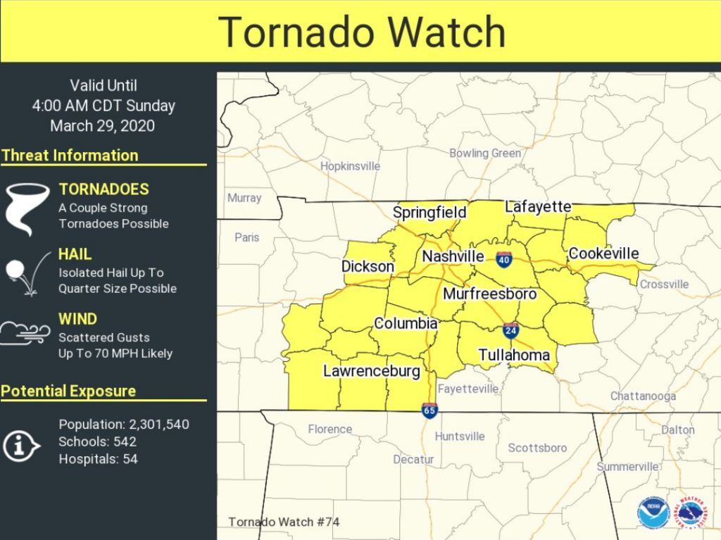
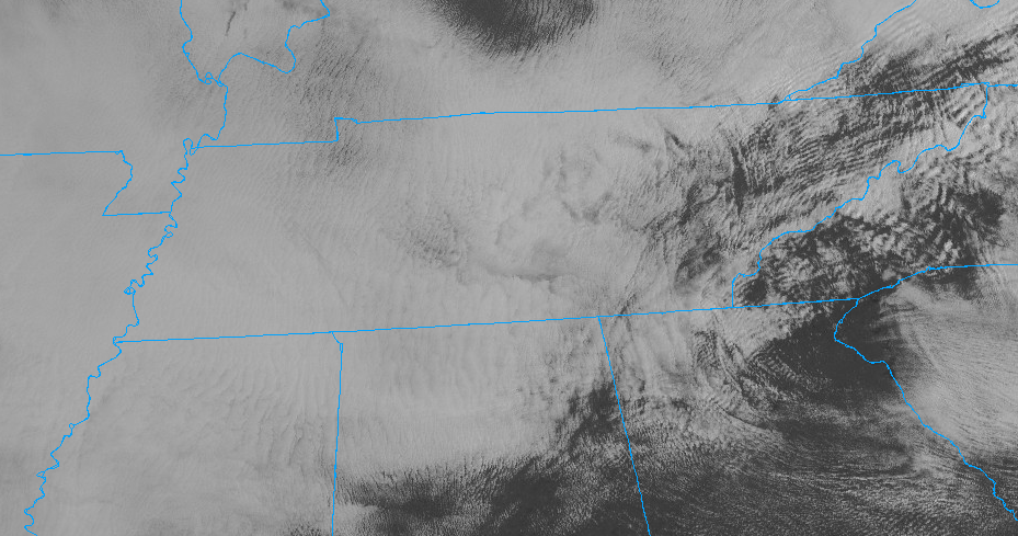
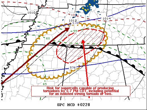
The Storm Prediction Center has issued a tornado watch that includes both counties, Davidson and Williamson until 4:00 a.m.

Tornado Watch until 4:00 am from the Storm Prediction Center

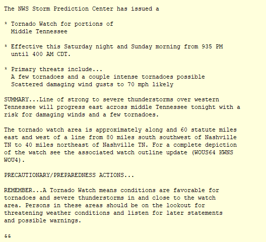
Text of the Tornado Watch
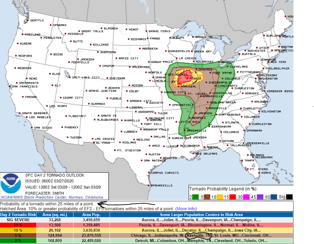
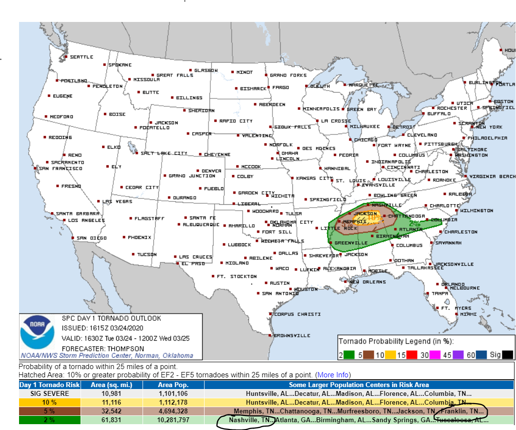
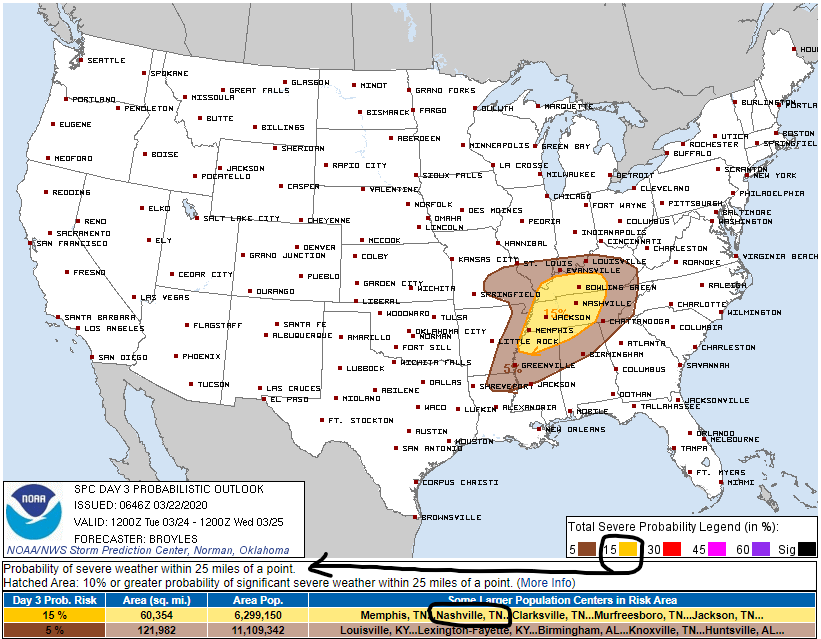
Probabilities

These are the probabilities of “x” happening anywhere in the tornado watch area. There is a 50% chance of 2 or more tornadoes in the watch area and a 30% chance of 1 or more strong tornadoes. See the table below for more info. read more

Severe Weather Possible Tonight: Damaging Winds, Hail, maybe a Tornado. Full details:

Storms are coming.

  • Storms should arrive between 10 PM and 2 AM, maybe even before that. Be weather aware.
  • Have multiple ways to receive warnings, especially after dark. (NOAA Weather Radio, local media, etc.).
  • Do you know where you would take shelter from severe weather?
  • New to severe weather? Click this.

Strong surface winds blowing from the southwest will gradually increase late this morning and this afternoon. Winds will transport humid air, fueling storms later. No rain or storms expected early/mid afternoon. read more

Saturday Night Storms, What To Plan For

Clouds today could limit our sunshine, but you’ll still get your fair share of it this afternoon. 84° for the high. That’s nearly 20 degrees above average for us for this time of year.

this is nice the santa clause GIF

Humidity is way up, dewpoints in the low 60s. For the first time this year we have to drag out the dewpoint/humidity translator: read more

Rain/Storms Expected Saturday Afternoon/Night (so far, it doesn’t look like a big deal)

Nice End to the Week

Thursday: Sunny, high of 81°, southerly winds of 5-15 MPH with gusts as high as 20 MPH.

Friday: Some clouds move in, dry, high of 83°.

Overall, a great end to the week.

The Weekend: Rain Chances Return

Saturday starts off dry, but the chance of rain increases later into the afternoon and evening. read more

Saturday’s Severe Storm Risk Shifted West.

Drying out and Warming Up

It’s cloudy. We hope to see these clouds disappear by this afternoon. Right now, this is what satellite looks like.

You can see these low clouds hanging over us. If I could animate this, you would see these clouds beginning to erode to our east. read more

Tornado Watch Canceled, Sun Returns Until Saturday When Severe Risk Returns

Tornado Watch Canceled, Severe Threat Over

The tornado watch originally set to expire at 10:00 p.m. was canceled early as the line of storms has moved east. We have been watching a warm front to our south all day to see if it would move far enough north to send severe storm food up into our two counties. The front just couldn’t get far enough north to accomplish this, and to that, we say…”fine with us.” read more

Tornado Watch Details for Williamson County

A Tornado Watch is in effect until 10 PM for Williamson County, not Nashville (not Davidson County).

Why not Nashville?

The warm front we’ve been talking about all day isn’t expected to make it to Nashville/Davidson County. The storms got here early/mid afternoon, and removed any fuel storms later could use to power up. No guarantees, but I think this will be a non-event in Nashville/Davidson County. But we could still see heavy rain, thunderstorms, even some small hail, but the tornado concern is nah. read more

Strong To Severe Storms This Afternoon/Evening. Have a Way To Get Warnings

Severe Storms Risks, Threats, And Timing For Today

Our first round of storms has already pushed off to the Northeast, but what we’re really going to watch is the greater threat with the second round of storms ahead of a cold front moving through this afternoon and evening. The Storm Prediction Center is currently monitoring these storms moving in from the West. We are listed in a mesoscale discussion. You can find it here…. read more

Severe Weather Threats, Timing, And Risks For Tuesday

Quiet The Rest Of The Day

Rain this morning moved out. Dry the rest of the day, clouds maybe breaking up a bit and providing a few rays of sunshine this afternoon. Temps a little below average, afternoon high 60°.

Severe Weather Threat Tuesday

Threats: The primary threat will be damaging winds and large hail. Tornadoesare less likely than damaging winds or hail, but still possible. Below, NWS-Nashville breaks down threats on a 0-5 threat scale: read more

Tuesday’s Severe Storm Timing, Threats, Risks

Light Rain Tonight – Overnight

Scattered light rain approaching late this afternoon, should be here tonight and continue heavier overnight, ending with just under 0.5″ sometime early Monday morning.

Heavier rain and non-severe storms expected between here and Nooga after 3 AM Monday . . . read more