
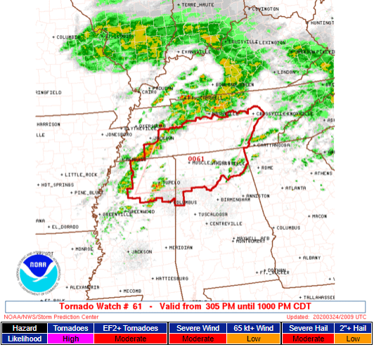
A Tornado Watch is in effect until 10 PM for Williamson County, not Nashville (not Davidson County).
Why not Nashville?
The warm front we’ve been talking about all day isn’t expected to make it to Nashville/Davidson County. The storms got here early/mid afternoon, and removed any fuel storms later could use to power up. No guarantees, but I think this will be a non-event in Nashville/Davidson County. But we could still see heavy rain, thunderstorms, even some small hail, but the tornado concern is nah.
Tornado Watch Details for Williamson County
A Tornado Watch means conditions are favorable for tornadoes and severe thunderstorms in and close to the watch area. Persons in these areas should be on the lookout for threatening weather conditions and listen for later statements and possible warnings.
Storm Prediction Center
The Tornado Watch expires at 10 PM, but we think the storms will clear Will Co by 7 PM. At 3:15 PM, storms are forming in SW Middle TN and N Mississippi, moving our way. Meanwhile, a warm front and surface low pressure center, both carrying supercell and tornadomaking ingredients, are on the way.
The tornado risks are higher in Spring Hill, lower in Brentwood. The further north you are, the lower your risk.
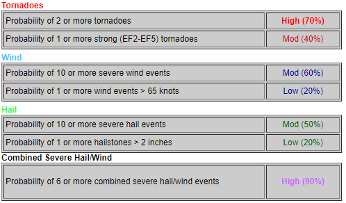
Probabilities for the entire Watch area (TN, MS, and AL, inside the red lines) are below:
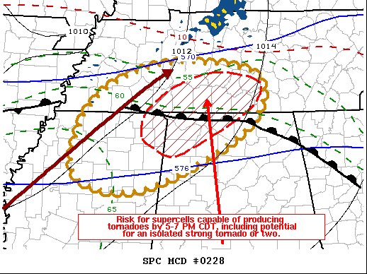
Notice the area of “strong tornadoes” is most likely south of Will Co in the red-shaded area. Travel south down 65 in Middle TN and N Alabama is discouraged.
Damaging straight line winds (70+ MPH) and large hail up to 1.5″ are also possible, along with heavy rain and frequent lightning.
If we have a Warning (take cover!), and Andrew will go live on our YouTube Live stream. Will and I will be tweeting and taking your reports via #tSpotter.
Categories: Forecast Blogs (Legacy)
You must be logged in to post a comment.