
Storms are coming.
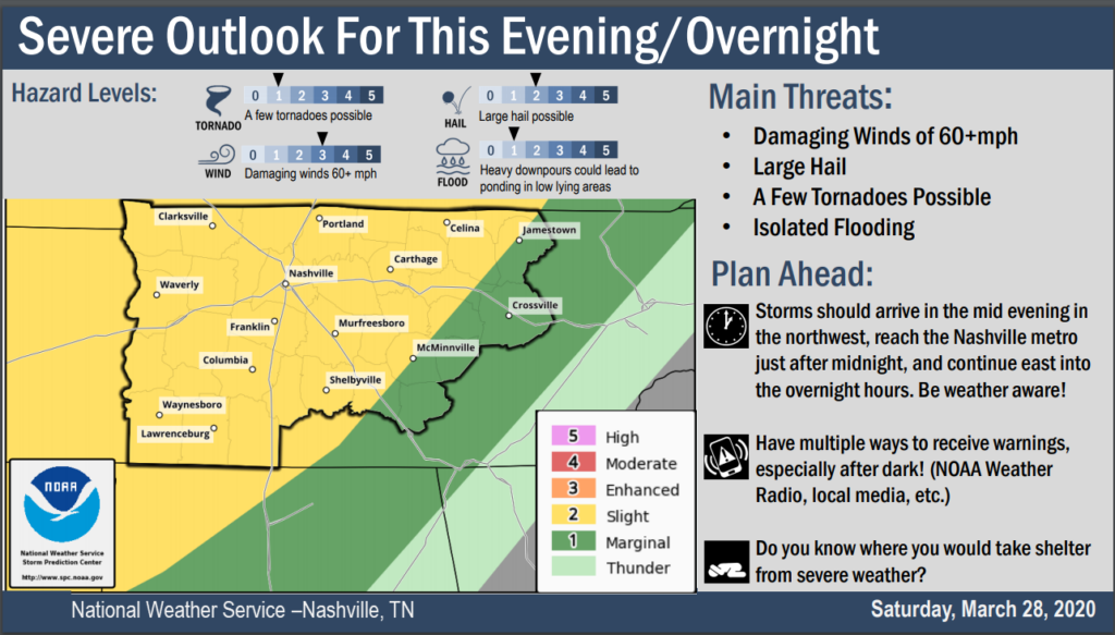
- Storms should arrive between 10 PM and 2 AM, maybe even before that. Be weather aware.
- Have multiple ways to receive warnings, especially after dark. (NOAA Weather Radio, local media, etc.).
- Do you know where you would take shelter from severe weather?
- New to severe weather? Click this.
Strong surface winds blowing from the southwest will gradually increase late this morning and this afternoon. Winds will transport humid air, fueling storms later. No rain or storms expected early/mid afternoon.
Meanwhile, a powerful area of low pressure will race toward the Great Lakes. For us this means strong winds sustained around 15 MPH, gusting 20-25 MPH. A cold front will extend several hundred miles north to south, then sweep east, part of it crossing the Mississippi River and through Middle Tennessee. The stage is set.
ETAs, threats, risks, and hazards depend on the storm type: supercells vs storm line. Each discussed below. This does not appear to be a Time To Freak Out event, but responsible individuals like yourself should closely monitor the situation through the day and night.
The Questionable Happening of Dinnertime & Early Evening Supercells
A few models hint at the development of storms near and north of I-40 after 4 PM. In addition, a low-level inversion (also known as a “cap“) materializes in the late afternoon and evening. The presence/strength of this inversion will play a role in the development of convection and is not well-handled by the models at this time.
NWS-Nashville, AM Forecast Discussion
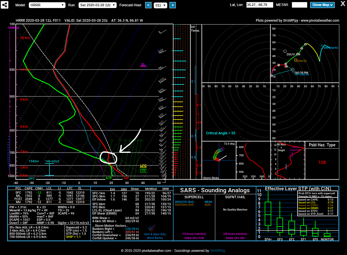
The HRRR model does not think dinnertime storms will happen. Why? The cap. The cap just means temps above are warmer than temps below, preventing storm formation. The HRRR model thinks at dinnertime, that “cap” is holding on, circled below:

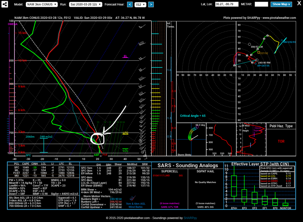
The NAM3 model also shows the “cap” preventing dinnertime storms.
If these models are wrong about the cap, watch out.
After dinner, winds aloft will increase, and may remove the cap. Storms can form in an uncapped environment. Supercells capable of damaging winds, hail, and tornadoes would all be possible.
That said, models are all over the place. Consider this run of the HRRR model for 9 PM tonight. The dinnertime cap is gone, but a new cap has formed near the surface:
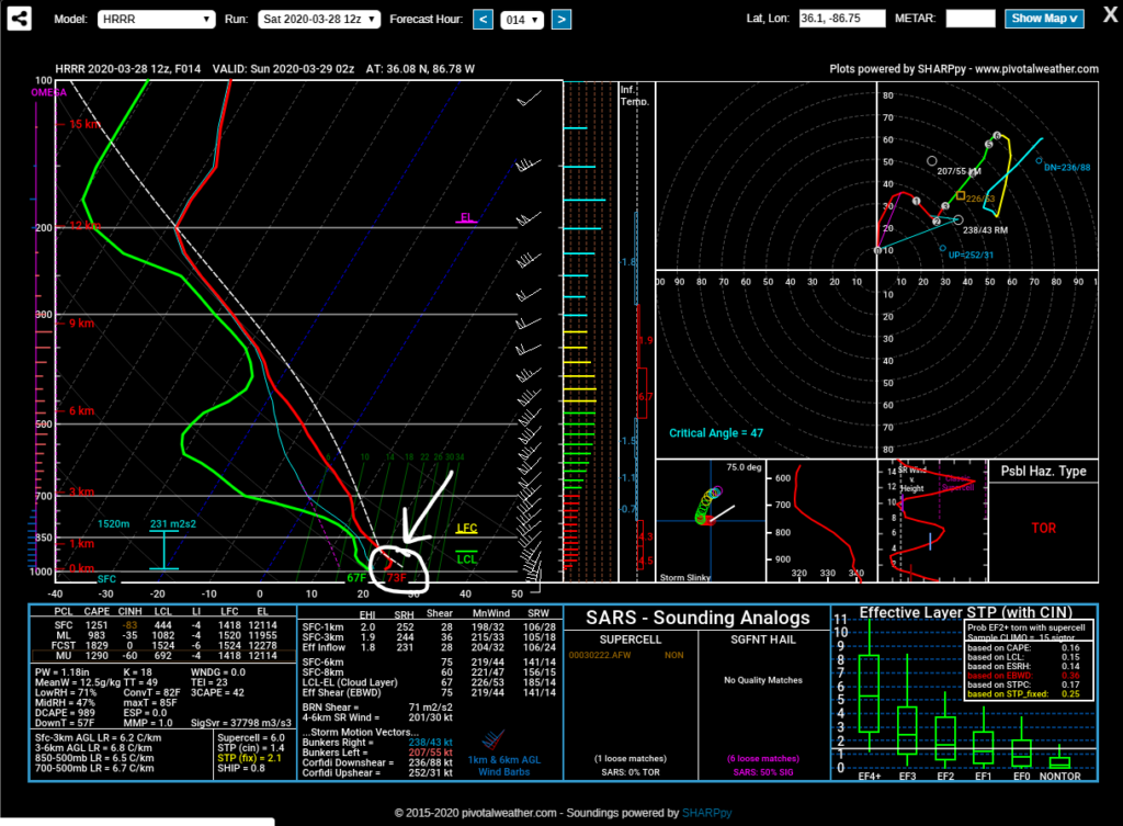
This wouldn’t keep a storm from happening, but it may reduce a tornado threat.
The bottom line is this: the models are confused about what’ll happen before the main storm line arrives late tonight. Without forecast confidence, you should be connected from late afternoon through this event for updated information. We don’t know exactly what will happen, but we do know the situation is volatile, there is a small chance of a low probability of a high personal impact to you via an evening supercell.
We will know more around dinnertime when the Nashville weather balloon goes up and will tell us what’s actually happening with the cap.
Main Event, A Line of Storms, Late Tonight
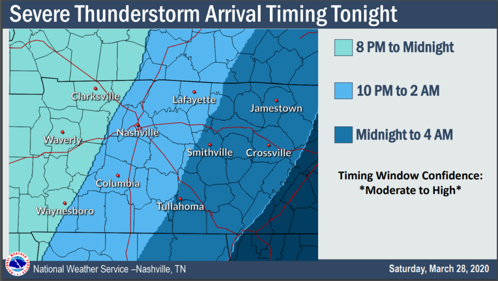
The main line of storms is expected to take shape over west TN and arrive along the TN River after 9 PM. Activity will push east to the I-65 corridor around midnight or shortly thereafter
NWS-Nashville, AM Forecast Discussion
10 PM to 2 AM ETA for us. Midnight is our best bet.
NWS-Nashville’s threat/risk guidance:
While damaging wind will be the most prevalent concern, a few tornadoes could develop if surface winds become increasingly perpendicular to the SW to NE storm motion. Large hail is possible, too, given lapse rates of 6.5 to 7 degC/km and a layer of 1000+ J/kg CAPE above 850mb.
NWS-Nashville, AM Forecast Discussion
The Storm Prediction Center expresses risks like this: tornado 5%, damaging winds 15%, hail 15% of happening within 25 miles of you.
A note about the tornado risk. We are studying the March 3 supercell. Among a hundred other things going on with that storm, surface winds were blowing from the south-southeast, then winds were turning clockwise (toward the west) with height. These are called veering winds. The delta inside a veering wind profile will be the main thing we look for tonight. If, as many models think, surface winds will be blowing out of the southwest instead of the south or southeast, then although the winds will veer maybe a little bit, damaging winds and hail will be the more likely outcome. We will be watching those surface winds tonight.
Storms should be moving too fast for significant flooding.
We will be with you all the way on Twitter @NashSevereWx and on YouTube Live in the event we get a warning. Seek out updated information; this information may be old, and will be updated on Twitter.
Sunday will be beautiful. The cold front will scrub away today’s humidity. Next rain event Tuesday.
We like StormWatchPlus, in IOS and recently for Android. The app feeds NWS forecast data (the best) and, most importantly, it has alerts that will wake you up. Like every notification device, you have to actually read the instructions and follow the settings. Don’t put your phone on do not disturb or turn down the volume. You have to pay for alerts, too, just like you have to pay for every other notification tool. It costs money to deliver you the alerts. We know the developer, he’s a Tennessean, and he cares about it working great for you. If you don’t like that app, find one you do like. Just have one on your phone!
Categories: Forecast Blogs (Legacy)
You must be logged in to post a comment.