
Clouds today could limit our sunshine, but you’ll still get your fair share of it this afternoon. 84° for the high. That’s nearly 20 degrees above average for us for this time of year.

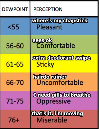
Humidity is way up, dewpoints in the low 60s. For the first time this year we have to drag out the dewpoint/humidity translator:
Saturday Night Severe Weather: Threats, Risks, ETAs
We’ll be dry throughout the majority of Saturday until the late evening hours, when our next chance of some severe weather rolls through.
Let’s start with how the NWS-Nashville breaks this down this morning:
“A tightening pressure gradient over the Ohio and Tennessee Valleys will help winds to gust 20+ mph Saturday afternoon and evening. In addition, a low-level 850mb wind max develops over west TN and slides east into Middle TN Saturday night. Diurnal surface heating will boost instability during the afternoon and evening hours. Thus, a line of rain and thunderstorms are expected to fire along the MS River Saturday afternoon, reaching the TN River by 00z-03z Sunday”
NWS-Nashville Forecast Discussion 3/27/20
Instability is like fuel to a storm. Diurnal surface heating increases instability as a line of thunderstorms pushes through Middle Tennessee. The Storm Prediction Center currently has Nashville and Williamson County at a 15% chance of seeing severe weather (damaging winds, hail, and/or tornado — keep reading) within 25 miles of you.

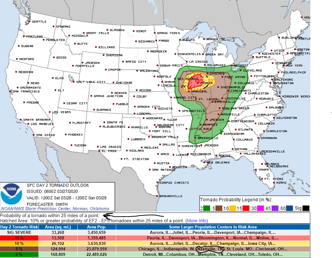
Threats: The main concern is damaging winds of 60+mph. Large hail isn’t much of a concern, but we still could see some small hail. A few tornadoes are possible somewhere in Middle Tennessee, and the Storm Prediction Center points that out by including us in an area with a 5% chance of seeing a tornado within 25 miles of you:

ETA: Models have come into a better agreement on timing, although minor adjustments might happen as we approach Saturday night. The current expected timing for this line of storms is around/after midnight.
As usual the NAM3 model loves this event, but the GFS and the Euro models suggest a low level inversion that would reduce our tornado risk.
Plan ahead and have multiple ways to get warnings now. Since this event is expected to happen later at night, possibly after midnight, have a plan in store ahead of time in case severe weather strikes.
Check back here and especially on Twitter @NashSevereWx for updated information. Forecast threats, risks, and timing improve the closer we get to an event. Replace older, generalized information with newer, more specific information.
NashvilleSevereWeather.com/shop & Subscribe to our YouTube Channel.

Categories: Forecast Blogs (Legacy)
You must be logged in to post a comment.