More Treat Than Trick, Protect Beloved Plants

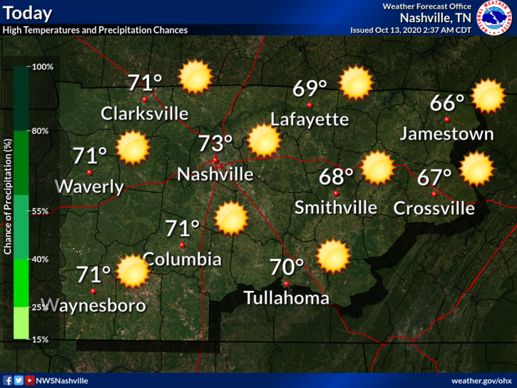
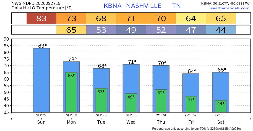
Perfect last day of October. Expect sunny skies with a high of 64!

Temps should drop into the upper 50s during trick-or-treating.

Tonight will feature mostly cloudy skies with a low of 50.
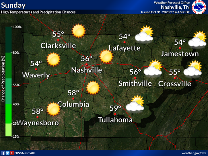
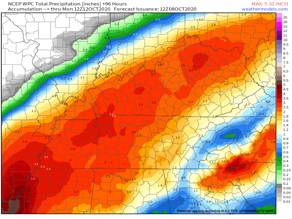
Breezy Sunday

A bit cooler Sunday with a high in the middle 50s. The big story will be the winds. Gusts around 30 mph are possible.

These winds will quickly die down by sunset Sunday evening.

Freezing Monday Morning

We are under a freeze watch.

A frosty Monday morning remains on track with almost all locations dipping below freezing and some locations along the plateau experiencing a hard freeze.

NWS Nashville AFD 10-31-2020

Forecasted Monday morning low for Nashville is 31. I think most areas will dip below 30. Planters need to take extra precautions in protecting plants that could be harmed by freezing temps.

Few degrees warmer Tuesday morning but still we could see a frost in some locations.

Good News

We warmup nicely as the week goes on. Maybe reaching the low 70s next week.

…And how about no rain for at least the next 7 days!

Have a great weekend!

Perfect Trick-or-Treat Forecast, Widespread Freeze Possible Monday

I think we can deliver!

The cloudy, dreary week that we have experienced is coming to an end!

Clouds this morning will erode and leave a mostly sunny sky this afternoon. Still quite cool and breezy with a high of 54.

The hourly forecast for Friday Night Football is chilly.

Definitely Jacket and Blanket Weather

Trick or Treat?

Definitely treat!

Saturday will start off cold with mid to upper 30s commonplace. Some patchy light frost is possible in some of the colder pockets but nothing substantial.

We will warm up nicely with low 60s in the afternoon until cooling down to around 50 during trick or treat festivities.

Cold Front Incoming

This cold front will sweep through Sunday night and bring the coldest air so far this season.

Heater Season

NWS Nashville’s AFD:

Lows Monday morning will be the coldest we’ve seen so far this season with some locations dropping as low as the upper 20s. We are certainly looking at widespread frost and potentially a widespread freeze. Tuesday morning looks like another widespread frost before temperatures begin to warm for the rest of the week.

10-30-2020

Plant enthusiasts will want to cover or bring beloved plants inside.

Another frosty morning possible Tuesday and then upper 60s to around 70 late week!

Drizzle. Zeta Should Create Some Midweek Rain. Treat Not Trick.

If you loved yesterday’s cool drizzle, today is also for you.

Green line close to the red line from this morning’s weather balloon means temps and dewpoints are in a serious, committed, long term relationship for today. Relative humidity 80% to 90% allows for drizzle.

Expect cloudy skies with occasional annoying drizzle.

But look on the bright side, it will be a few degrees warmer without yesterday’s wind, highs low 60°s.

Tonight could still feature a chance of drizzle and even some patchy fog. Low of 52.

Quiet Monday and Tuesday

We’ll get a break in the precipitation Monday and probably Tuesday as well. Clouds will linger both days but don’t be surprised if the sun surprises us Monday.

Euro Model keeps any Monday and Tuesday rain/drizzle to our west and east.

Another Gulf Storm?

Yep. Tropical Storm Zeta will make landfall along the Yucatan sometime Monday night. Once it gets out into the Gulf of Mexico, it is forecasted to strengthen into a hurricane before making a second landfall somewhere along the northern Gulf Coast.

NHC thinks the center of Zeta will landfall somewhere between central LA and the FL panhandle.

What does this mean for us? All depends on where Zeta goes, and whether one side or the other is the wet side. For now, expect an increase in showers Wednesday/Thursday at the very least. Most likely Thursday morning, but some (not all) data shows potential for heavy rain Wednesday that’ll rain everything out.

Temperatures won’t be that bad though. Maybe low 70s towards the middle of the week.

Too early Trick or Treat forecast looks cool but dry. Upper 50°s.

Rain Likely Friday, Fall-Like Temps Return This Weekend

Another “non-pumpkin-spicey” day. High of 85(!) and humid. Dew points in the 62-64 range.

Also this…

Rain should hold off until Friday, so tonight will be dry and still warm with a low of 64.

Rain Friday

Models are in pretty good agreement with timing.

GFS Model is a few hours faster than the Euro. It predicts rain moving in closer to sunrise.

The Euro Model leans closer to 10AM-Noon.

Either way, both models predict us getting rain during the morning. They also have the rain moving out before sunrise Saturday.

While severe weather isn’t anticipated locally, SPC has a low-end risk for parts of north/northwest TN.

5-10% of severe weather within 25 miles of a given point

Here’s what NWS Nashville said this morning in their discussion

Main concern with any strong to severe thunderstorm activity will be strong to damaging winds and large hail.

NWS AFD 10-22-2020

Our tornado concern level with this system is very low.

How much rain? Due to the scattered nature of these predicted showers/storms, your backyard will vary.

0.25-0.5 inches seems like a safe bet. Locally higher amounts are possible with any downpours.

Weekend Fans

With the passage of a cold front, Saturday looks to be quite cool. Highs staying in the mid 60s before we warm back up Sunday-Monday to upper 70s.

Unfortunately, temperatures will seesaw over the next 7 days. Another cool down (and more rain) possible by early next week.

Perfect Fall Weekend

Behold the Urban Heat Island…

We will warm up to 68° today with bright sunshine.

No 30 degree temps tonight. Lows should settle in the upper 40s to around 50. Warmer than this morning was.

Sunday

Few more clouds than Saturday and touch warmer with a high of 71°. Perfect for a noon kickoff. Expecting a south wind around 10 MPH or so., for all those times Kern will be holding the PATs.

Euro model develops some showers over West Tennessee. Some of those might try and make their way close to us Sunday afternoon.

Unlikely we will get wet. Something to watch.

Heating Up Next Week

Mid 70°s to start the week maybe touching 80! by mid-week.

There are some signs that rain might return at some point during the week but models disagree on when and how much.

Euro Model keeps up dry early in the week with showers/storms missing us to our northwest

There is some evidence that rain could return by next Friday but there’s still plenty of time to iron out those details.

Until then, enjoy this beautiful fall weekend.

First Frost Likely Saturday Morning.

To be social is to be forgiving.

Robert Frost

The cold front that moved through yesterday left us with a beautiful fall day.

Need I say more

Tonight will be cool with a low of 46°.

Similar story Wednesday albeit a bit warmer. Maybe touching 80° by the afternoon.

Another Cold Front Late Thursday

Cold front ETA Thursday night. Some light rain is possible with this passage.

Euro Model isn’t impressed, only light rain. Doesn’t look like a rainout.

GFS also has the same idea. Precipitable Water (measure of moisture in the atmosphere) isn’t impressive, but enough for at least isolated showers.

Any rain will quickly exit the area by Friday morning.

Temperatures will fall behind the front.

Notice that “38” Saturday morning! That’s the morning we’ll have to watch for a frost. NWS Nashville mentions this possibility in their discussion.

After a pretty warm weekend, highs Friday will be mainly in the upper 50s to lower 60s, with mid and upper 30s following Saturday morning. This will likely produce patchy frost across much of the area.

NWS AFD 10-13-2020

Grass seed/plant enthusiasts should take note. Still a little early for our typical first freeze but if you live outside of Nashville, your Saturday morning temp could be a couple degrees cooler. 38° is the official low at BNA, many backyards get colder than that. Not expecting anyone to freeze (at least right now, we aren’t), but frost is likely.

season 12 episode 6 GIF

Tropical Depression Rain This Weekend. Timing? How Much Rain? Severe Concerns?

Few passing clouds today. No worries. High 85.

Delta Expected This Weekend as a Depression

Hurricane Delta is expected to make landfall on the Louisiana Coast Friday Evening. It will impact the same areas, now covered in blue tarps, because of Hurricane Laura.

Models starting to agree on timing.

The GFS model predicts light rain as early as Friday night, a break during the day Saturday, then off and on precipitation Saturday afternoon/evening through Sunday afternoon/evening.

The Euro model is very similar. Light rain as early as Friday night, with off and on heavier rain through the weekend.

Some of the rain could be heavy at times, especially Saturday-Sunday. Both models end the rain Sunday night-Monday morning.

Washouts possible, but flooding not a current concern.

We’ve been dry the past few weeks, so rain will be absorbed. Rain will be spread out over the weekend, allowing for runoff.

2-3 inches total seems to be the general consensus. Note: These totals still could be adjusted. Any slight deviation of Delta’s center to the east or west could mean higher or lower totals.

Severe Weather?

Also not of great concern but as always with weakening tropical systems, we’ll watch for a low-probably/weak tornado threat. SPC keeps the a low-end threat just to our south.

Here’s what NWS Nashville says:

The severe weather risk with Delta appears quite minimal as forecast instability will be near zero and the associated low level wind fields look to weaken quite rapidly as the system moves across Middle Tennessee.

NWS AFD 10-08-2020

No instability = no tornado concerns. But with the center passing very close by, you can never totally rule a brief, usually weaker spin-up. Anxiety level is near zero.

Editor’s Note: I would not lose sleep over it.

Winds could gust in the 25-35 mph range but that isn’t enough to warrant concerns.

Stay tuned in to future updates as Delta approaches and make sure you are receiving the newest information.

Cooler Air Has Arrived!

Tuesday

Fog to start the day has since cleared. Expect a high of 69 with partly cloudy skies.

Can’t rule out some drizzle as an upper low moves into the area. HRRR Model isn’t very bullish:

These will be a nuisance more than anything. Most will stay dry.

Warmup Wednesday

If you were tasked with creating the perfect weather day, this is it.

Sunny, high of 76, low dew points, no rain.

Even Cooler Air Coming

Another cold front will drop from the northwest Thursday. This will bring a reinforcing shot of fall air.

Might see some clouds along the front but no rain is expected.

Highs will drop into the 60s over the weekend with low 40s very likely overnight away from Nashville. Wouldn’t be shocked for someone to touch the upper 30s.

NWS Nashville didn’t mention issuing a frost advisory in their discussion this morning.

Morning lows in the mid-40s are still expected Friday morning and even cooler come Saturday morning — maybe even some upper 30s on the Plateau.

NWS Nashville Discussion 09-29-2020

Good news for planters.

Cooler temps are expected to stick around.

CPC shows slightly below normal temperatures continuing through at least October 12.

You need a rain jacket Monday. And a real jacket this week.

Sunday will be partly cloudy with a high of 83. Dewpoints in the mid 60s will make it feel sticky as well.

Upper-level low to our south might try and bring up a few Sunday afternoon showers. HRRR Model isn’t impressed and neither are we.

Don’t cancel outdoor activities as most will stay dry.

A few passing clouds to tonight with a low of 64.

Rain Monday

Monday will have a “fall feel” to it. Our high will come around noon and once a cold front passes, temperatures will fall throughout the afternoon.

Temperatures going the wrong way Monday

The 1-hour Euro model predicts rain beginning as early as noon, lasting through the afternoon hours.

Most of the rain will come after the cold front has passed. This will eliminate meaningful severe weather concerns.

Thunder will be possible directly along the front and the bulk of the rainfall should be post-frontal. More shear is available due to the front, but soundings quickly become deeply saturated, killing lapse rates and removing any excessive chance for convection to get started.

NWS Nashville AFD 9-27-2020

Previous model runs suggested that rain may linger into Tuesday. That now looks unlikely. So probably rain just in the afternoon into the evening.

Rainfall totals look to be in the 0.25″ to 0.75″ range with some spots maybe getting an inch. But on average, expect 0.35″ or so, which is usually enough to rain out Monday night sports stuff. Depends on your field.

Monday’s rain is the only expected rain event until at least Saturday, October 3.

Chill in the Air

Check out the temp drop in the week ahead.

monkey ikea GIF

A second cold front will drop through Thursday-Thursday night. For now, it looks like the front will pass in dry fashion.

This will allow for fall temps to settle in.

Lows in the mid 40s are likely. Some of the colder spots may see low 40s Saturday morning. Remember in many low lying areas backyard temps can drop more than a few degrees below the official low.

Our average first Fall frost happens November 1. NWS-Nashville didn’t mention frost concerns in its forecast discussion covering the next seven days, so that’s a good sign for planters. But I’ll bet a few backyard weather stations will see upper 30°s around sunrise some time in the next seven days.

Warm Weekend Then Fall Fans Rejoice

But First Some Welcome News

Hurricane season runs through Nov. 30

Not a single system on the map and nothing is expected to form over the next 5 days.

After a busy couple of months, we could use a break

Warm/Humid Saturday

Dense fog this morning will give way to partly cloudy skies and warm temps this afternoon. Highs should top out at 80. No rain.

Dew points will be in the mid 60s which will make it feel rather sticky.

Rain Chances Increase Sunday

Maybe a touch warmer and more humid. Low 80s for highs with dew points in the mid 60s.

Might have to dodge a shower or two.

Euro Model shows some activity during the afternoon hours.

If a shower interrupts your cookout/lake trip/golf outing, probably won’t last long with no flooding or severe concerns.

Cold Front Szn

Before we feel the cool air and low dew points, we’ll have to deal with the rain.

Cold Front #1 will swing through Monday. This will bring an increased round of showers/storms. Severe weather looks very low at this time.

Here’s what NWS Nashville says

Next chance of rainfall for all comes on Monday as a cold front is set to move through the area. Could see some periods of heavy rainfall and a few storms Monday afternoon. Expecting total rainfall amounts to be below 2 inches.

NWS AFD 9-26-2020

Accordingly, WPC has introduced a low-end flash flooding threat for us Monday.

5%-10% Risk of Flash Flooding within 25 of your location

Rain should hang around Tuesday before ending Tuesday evening.

Make Way Cold Front #2

The second front will push through Wednesday night-Thursday morning. Once this moves through, highs could drop into the 60 with morning lows in the 40s!

CPC shows a very high amplitude pattern. Above normal temps west of the Rockies, below normal temps east of the Rockies.

Enjoy the warmth this weekend.