Rain Unlikely Today & Friday. That All Changes This Weekend.

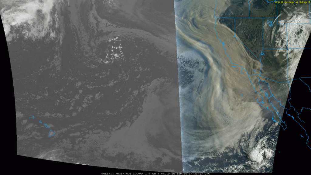
A non-Zoo tiger is loose in Knoxville, parts of hurricane hit Louisiana remain without power, and check out the smoke covering large parts of Oregon and California.

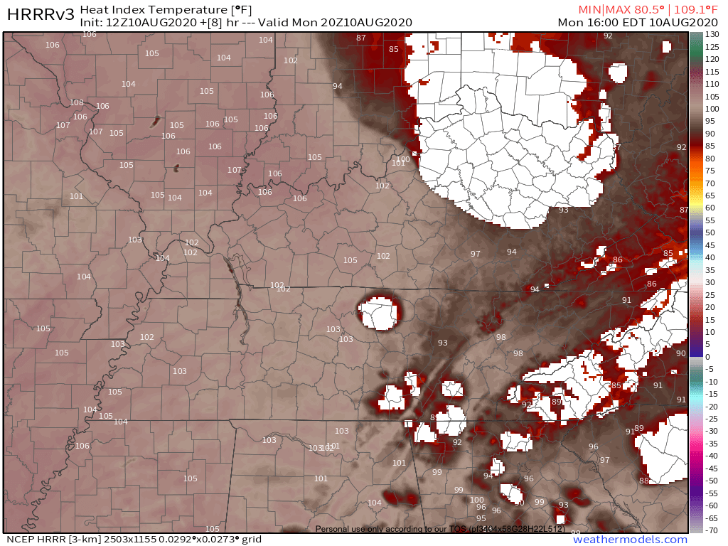
Things aren’t so bad here.

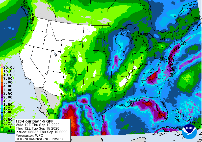
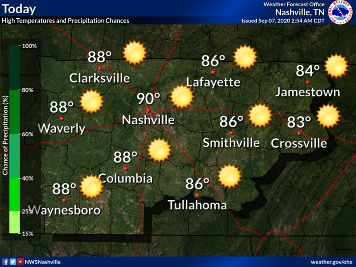
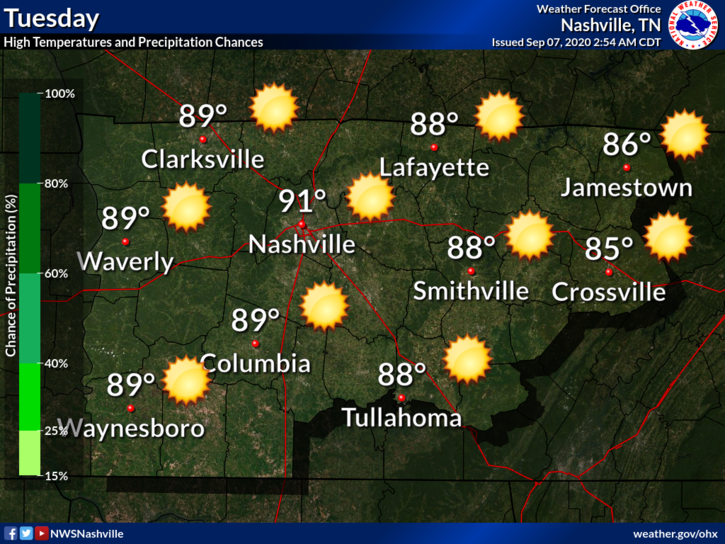
Plenty of sunshine Thursday with a high around 91. The rain will be way east of us.

Dew point values will continue to be in the upper 60s to around 70. Uncomfortable at best.

Friday

Similar to Thursday. High around 90 with dew points around 70.

It’s possible that someone might see a stray shower but I think the majority of us will stay dry. HRRR Model shows one or two showers popping up around Davidson/Williamson Counties, mainly during the afternoon.

HRRR Model 9AM-7PM Friday

If one happens to pay your backyard a visit, it probably won’t last long with no flooding or severe concerns.

Wet Weekend?

We know two things for sure: It’s going to be warm with temps in the upper 80s, and very humid. Dew point values both Saturday and Sunday will be in the low 70s.

Rain will increase Saturday and especially Sunday as a boundary lifts northward. A cold front will also setup to our northwest Sunday.

We are well in range of some of the higher-resolution models like the 1-hour Euro Model. It shows scattered-numerous showers and maybe some storms rolling through both Saturday and Sunday afternoon/early evening.

Briefly heavy rain and lightning are possible. Severe weather is not a concern. Here’s what NWS Nashville says about this weekend:

By early Saturday moisture will be pretty deep and will remain so through Sunday night until the front passes. Instability will also be more elevated and over the weekend we are looking at scattered/numerous shower and storms… especially in the afternoons. Severe parameters still unimpressive at this point.

NWS AFD 9-10-20

Rainfall totals will vary due to the scattered nature of the showers but it’s not out of the question for someone to pick up an inch of rain this weekend (or get nothing at all). Most should see rain somewhere in between.

WPC QPF Through Tuesday Morning

Next Week

We might get a brief break in the rain Monday with better rain chances Tuesday/Wednesday. Temperatures and dew points look to back off some as well.

Humidity on the Rise, Rain Chances Slim Through Friday, and a Tropical Update

Tuesday

Full supply of sunshine today with temps around 92.

You might feel a little stickiness with dew points in the low 60s but nothing too unbearable.

Clear conditions tonight with a low of 67.

Rising Humidity Wednesday

No change to the “warm and dry” part of the forecast with a high of 91. Humidity, however, will be a bit higher with dew points in the mid to upper 60s.

Isolated Showers Late Week

A weak front will push into our area from the northwest Thursday and should move south of us by Friday (as noted by the blue line along the Southern TN border)

WPC Fronts Map

This might try and squeeze out a few widely spaced showers. We’re not convinced and neither is NWS Nashville:

This front will be quite shallow, and moisture will be limited, thus we are only looking at only isolated showers/storms Thursday afternoon on the Plateau, and across the south/east on Friday. But most will remain dry, really through Fri night.

NWS AFD 9-8-20

If any showers form, they will probably be short-lived with no flooding or severe concerns. Temps remain around 90.

Weekend Rain?

An upper-level low will work its way out of the High Plains and into the Great Lakes this weekend. This will drag a cold front into our area Sunday.

While it’s too early too say how much rain we might receive, it’s looking like we’ll have to dodge some showers in the Saturday-Monday timeframe. We’ll be much more specific on this in future blogs.

Active Tropics

The climatological peak of The Atlantic Hurricane Season is Thursday and it’s already been an active season.

NHC 5-day Tropical Outlook

Paulette and Rene are the only named storms right now, both at tropical storm strength. They will gain latitude over the next few days and will likely recurve east of Bermuda with no threat to the U.S.

There are two other areas to watch: one southwest of Bermuda could develop into a depression and bring rain to the Carolina Coasts, the other is about to leave the African Coast. It’s way too early to know if it will have any impacts on the U.S. Just something to watch for now.

Beautiful Weather This Week, Even Better Late Week/Weekend

#Perfect

Slight uptick in humidity Monday but still comfortable. High of 90 with no rain.

Clear skies tonight with lows in the mid 60s.

Rinse and Repeat Tuesday

Maybe a touch more humid with another high at 90. No rain again.

Rain Wednesday-Friday looks… meh

Upper-level ridging will make it very hard to get deep moisture in here, NWS Nashville notes:

SFC/LL high pressure currently over the area expected to stay put into late week, as ridging builds aloft. These features will keep good deep moisture advection from occurring throughout the week.

NWS Nashville AFD 9-7-20

It’s not out of the question that you might get a quick, passing shower but certainly nothing heavy or severe.

Rainfall Outlook from WPC shows barely a 0.10″ through next Monday

WPC QPF

A frontal boundary will move through this weekend and that might be the focus for better coverage in showers/storms. We’ll also see some cooler temps.

Below normal temps look to stay with us through the official start of fall!

CPC Temperature Outlook Sep 14-20

Hot, Steamy, Maybe Some Rain Saturday, Better Chances Sunday

Laura is now a post-tropical cyclone situated over West Virginia. It will continue moving to the east and go off the eastern seaboard later today. We say good riddance.

Saturday

Sticky, Sweaty, Unbearable Humidity. Highs at 90 with dew points in the low 70s. Rain is iffy today. HRRR model shows a line of showers/storms moving south out of Kentucky and clipping the eastern part of our area later this evening.

HRRR Model Through Midnight

There is plenty of storm fuel and moisture to get storms going per NWS Nashville:

Forecast models show 1000-2000 ML CAPE with precipitable water values from 1.5-2.0 inches. This means storms with brief heavy downpours and the possibility for localized damaging winds.

NWS Nashville AFD 08-29-20

SPC has us put us in a 5% risk for severe gusts within 25 miles of your location.

SPC Damaging Wind Outlook Saturday

Tornadoes and large hail are of no concern.

We’ll watch trends closely should storms roll in.

Better Rain Coverage Sunday-Monday

HRRR Model shows a batch of showers moving through in the morning hours Sunday with a break around noon. Then more showers come in from the west in the afternoon.

HRRR Model Through 7PM Sunday

There could be some flash flooding concerns, especially with the heavier downpours. WPC has introduced a 10-20% risk for flash flooding within 25 miles of your location.

WPC Excessive Rainfall Outlook

Rain should taper off during the afternoon hours Monday with more rain possible Tuesday. After Tuesday, we should get back to the typical summertime forecast.

Rain amounts through Thursday morning could exceed 3 inches in some spots.

WPC QPF

There is some good news. Temperature won’t be too bad next week

EDITOR’S NOTE: This doesn’t make it better.

Here are the forecast highs.

Numerous Showers/Storms Through Saturday, Heat Relief Continues

Low pressure system over the Gulf will lift northeastward and provide our area with plenty of showers/storms the next couple of days.

HRRR models paints a wet picture. It appears anytime after 3PM would be the best time for seeing the heavier downpours

HRRR Model Through 2AM Saturday

Storm Prediction Center has dropped the 5% damaging wind risk for us but some sub-severe gusts are always possible.

We are however included in a 5-10% risk for flash flooding within 25 miles of your location with higher chances just to our west.

Friday’s Excessive Rainfall Outlook From WPC

Same story different day on Saturday

Rainfall totals through Saturday could easily exceed 1 inch in spots while others may not see a drop.

The one bright spot is that temperatures will be very comfortable. Dew points will still be in the upper 60s but temperatures will stay in the low to mid 80s.

Less Numerous Showers Sunday

It’s looking more and more likely that Sunday will be a much drier day. Can’t rule out a stray shower in the afternoon but nothing widespread or heavy.

Euro Models Doesn’t Show Much Sunday

Next Week.

Hot and sticky. Dew points in the low 70s and temps in the low 90s will make it feel miserable.

Rainfall next week (especially late next week) will be dependent on what happens with new tropical systems as they enter the Gulf.

More on these tropical systems as they evolve.

Humidity Relief is Here! Only Slight Rain Chances Next 7 Days

Beautiful Monday

High of 89 with dew points low-mid 60s. We will definitely take that for mid-August. No rain today with mostly sunny skies. Go outside and enjoy it.

Tonight will feature clear skies with temps hovering around 70

Tuesday

Rain chances creep upwards but still not looking at a lot.

Slight Rain Chances at Best

A weak disturbance moving through will provide enough lift for maybe a few scattered showers.

Euro Model (like yesterday) shows barely a drop.

Here’s what NWS Nashville says:

This feature will interact with increase capes by afternoon and there will be enough forcing to prompt the development of convection, especially in the afternoon. Just a general risk will be in place

NWS Nashville AFD 08-17-20

Don’t cancel outdoor plans. Have your radar nearby and check @NashSevereWx on twitter for any updates on storms should they form.

Looking Ahead

Humidity starts to increase mid-week and upper 60s to around 70 dew points return just in time for the weekend. This also means better rain chances.

WPC Rain Forecast Through Monday Morning

Still not much but of course individual backyard totals will vary.

Temperatures not too bad either

Enjoy the lower temps and humidity! We’ll be over on Twitter if any storms get going.

Dangerous Heat Monday, Daily Rain Chances Return

August heat and humidity…

Low 90s for temps and low 70s for dew points means dangerous heat indices. HRRR Model is very bullish with a max heat index of 103.

HRRR Model valid at 3PM

Upper 90s to around 100 appear very likely. Limit time outside during the peak heating hours and check the backseat!!

SPC has also put all of our area under a 5% risk for damaging winds within 25 miles of your location.

SPC Outlook for Monday

Damaging winds and frequent lightning are the main risk. Tornadoes and large hail are of no concern.

Localized Flash Flooding could also be an issue if a storm parks itself over your backyard. WPC puts us in a 5-10% risk for flash flooding within 25 miles of your location

WPC Excessive Rainfall Outlook Monday

Latest run of the HRRR Model keeps most of the activity just to our east.

HRRR Model

I think our coverage will be a bit more numerous than what this model is predicting.

NWS Nashville thinks…

No real atmospheric shear of note, but with CAPE values approaching 3,000 J/kg by late afternoon and PW values approaching 2.0 inches, some stronger thunderstorms could produce gusty strong winds

NWS Nashville AFD 08/10/20

With this much energy and moisture in the atmosphere, expect a few storms this afternoon.

Heat and Rain Chances Each Day

Low 90s will be the theme for a while

Daily temp outlook

Rain will also be commonplace. Tuesday should provide us with a better coverage of showers and storms. Also expect daily afternoon and evening storms in the area Wednesday through the weekend.

WPC Rain Totals through Monday 8-17

1-2 inches is very possible over the next 7 days with higher amounts not out of the question.

Wonderful Through Weekend, Typical August Heat/Humidity Next Week.

Friday = Awesome

No rain, high around 90, tolerable humidity.

Sunny Skies

Fire up the grill, head to the golf course/lake, do literally anything outside today.

Weekend

NWS Nashville mentions ridging will build starting Saturday. That with a surface high over the Gulf will help increase moisture return, thus better rain chances next week.

It’s influences won’t be felt over the weekend though.

Rain staying to our west Saturday

Temps should be a touch warmer and bit more humid. Rain might try and make a comeback Sunday evening but that’s a stretch.

Change Is Near

Don’t get too comfortable with these nice days.

Euro Model hints at mid 90s for a few days and maybe an inch of rain next 7 days.

Not a forecast. Just guiding us to what might happen next week. Definitely better rain odds

Enjoy the weather this weekend

More Rain On The Way. Storms, Too.

Showers and storms will start to dot the radar this afternoon.

HRRR Model fires up storms just after noon and keeps them around a few hours after sunset.

HRRR Model Through Tonight

Temperatures will still be in the low 90s but where showers do form, expect a brief cool off.

When/Where exactly these will form remains a bit of a mystery.

Parts of town got nailed by a 3″ downpour last night. Those areas are today water intolerant. Flash flooding should happen there if we get 2″+ over three hours:

If blank, model image not available

Heavier Rain, Storms Begin Thursday.

Thursday starts a string of cooler days because clouds and rain should block the sun.

Thursday

Rain won’t be classic summertime “who knows where it’ll pop up.”

It’s coming in waves.

HRRR model illustrates:

WPC has our area in 10-20% risk for flash flooding within 25 miles of your location.

WPC Excessive Rainfall Outlook Thursday

Storms are also possible.

[S]easonably high moisture content will contribute to heavy precipitation loading, and perhaps enhance the risk for potentially damaging wind gusts.

SPC Convective Outlook

Damaging wind gusts from collapsing heavy thunderstorms are possible Thursday. Probability is 5% within 25 miles of you.

HRRR model also paints a few streaks of updraft helicity through the region Thursday. Tornadoes are not expected, but this is not your typical July storm setup. High helicity storms should be more efficient rainfall, lightning, and chaos producers.

Rain is possible all day (not just the afternoon), but is more likely in the afternoon.

Friday

More heavy rain should come in waves. Not an all day washout, but the rain we get should be heavy, and it may even continue into Friday night overnight to Saturday morning.

Here’s the Euro model for Friday into early Saturday morning:

Flash Flooding concerns will continue into Friday and Saturday morning:

WPC Excessive Rainfall Outlook Friday

Storms each day could contain gusty winds but overall severe risk is low. Main threats will be heavy rainfall and lightning.

Weekend Weather

Saturday begins the month of August, but the rainy pattern will continue especially into Saturday.

Rain may even linger into Sunday, but we expect the heaviest/most rain between Thursday and Saturday.

WPC is forecasting a total of 2-4 inches of rain by the end of the weekend.

WPC Rainfall Outlook Through 7AM Monday

Biggest takeaway for the next few days: never drive over flooded roadways no matter how shallow it might look.

One side benefit to all this rain: lower temperatures, below average as we enter a typically scorching month.

CPC Temperature Outlook August 3-7

Scattered, Sunday Afternoon Storms. Wet Week Ahead.

Same forecast as the past several days: hot, humid, chance for mainly afternoon/evening thunderstorms.

Will it rain at your bbq at 5PM? We simply don’t know. Someone’s bbq will probably get rained out at 5PM, but we can’t pinpoint exactly who will get it and when it will happen. Not in the summer.

HRRR Model has the storms breaking out between 4-6PM and quickly fading just after sunset.

HRRR Model Through 10PM

Severe weather isn’t of concern but be aware of gusty winds, heavy rainfall, and lightning.

Lightning isn’t technically “severe” unless it happens to you.

https://twitter.com/Crackerfarm/status/1287198668261646337?s=20

More Rain Coming — More Than Usual

Change is coming.

Rain and storms will still be more likely each afternoon, but will also be possible in the morning and after dark this week.

This week, severe weather (tornadoes) not a concern. Lightning and downburst straight line winds the main hazards. Flooding may turn into a problem late week.

Monday rain should be widely scattered. We may not get hit. HRRR model for Monday:

Tuesday a front stalls nearby and should create several storms and downpours. Maybe not a total washout. NWS has about 0.20″. WPC says 5% to 10% probability of flash flooding.

Wednesday’s rain coverage increases. Below is the Euro model. Waves of rain coming in.

Almost 1″ of rain expected:

Thursday should be rainiest, morning and afternoon especially. Data is low res for this time period but all indications suggest washout possible (not guaranteed). Another inch or so.

Rain/Cloud cover will be extensive. Very humid, but highs under 90s, only because we won’t have the sun beating down on us all morning.

Friday: more rain!

Flooding may be an issue Friday with all the rain we’ll have had this week, and more likely Friday afternoon. Rain remains possible Saturday. By Sunday, WPC thinks we’ll have seen close to 4″ total for the entire week.

WPC Rainfall Outlook Through Next Sunday