Rain Today, Storms Possible Monday, Stronger Storms Possible Wednesday

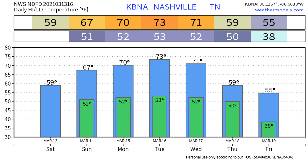
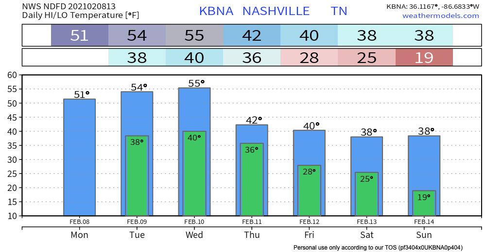
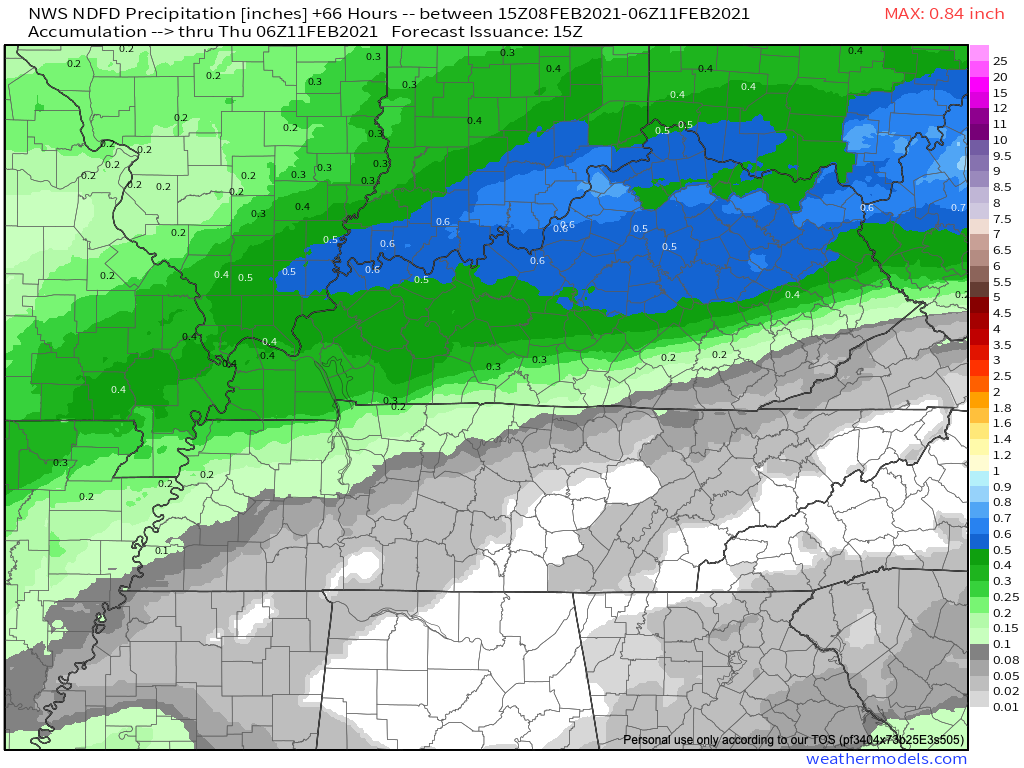
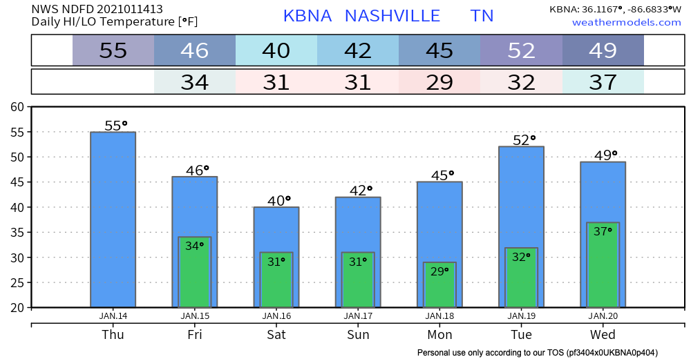
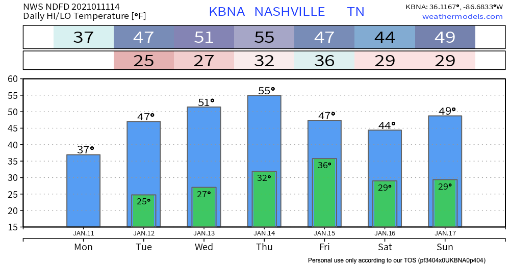
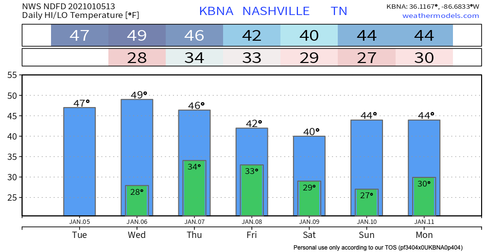
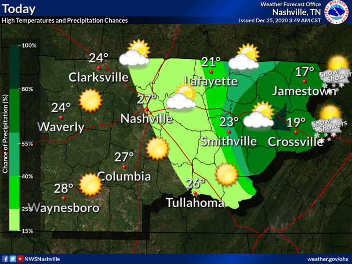
An east-west line of storms will continue to impact the area.

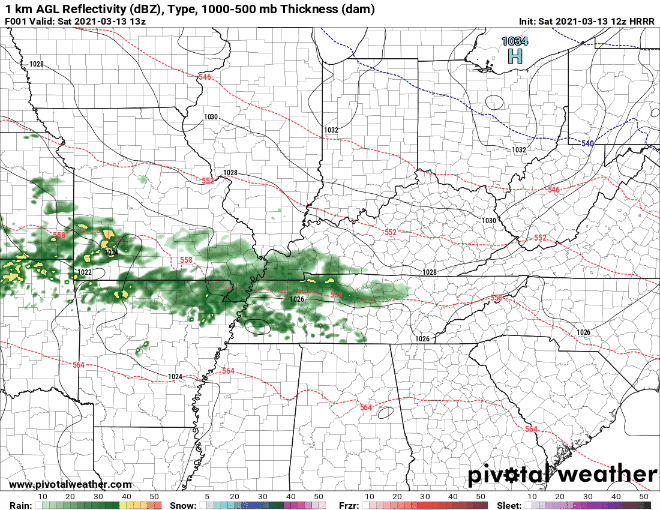
As expected, more rain north, less to the south. This activity will begin to taper off later this evening, with only spotty showers tonight. Washout potential is low but a good soaking is expected. read more

Three Waves of Rain (Storms?): What We Know (And Don’t Know)

#TBT

https://twitter.com/StormyClaussen/status/1370008547854057479?s=20

Those “warm and happy thoughts” will lead to high near 80 today.

Warmer temps will provide more energy for showers to develop Thursday afternoon. HRRR Model predicts most of the showers will stay to our north. read more

‘Severe CLEAR’ For A While

A chance to connect with us…

Register here for a discussion with the Nashville Severe Weather team tonight at 5:30pm hosted by the National Weather Service, Nashville as a part of severe weather awareness week.
CLICK HERE TO REGISTER read more

Sorting Through Uncertainty about Rain vs Ice Thursday and Snow vs Nothing This Weekend

A drizzle or two is possible Tuesday and Wednesday but most of the precip should pass north and northwest of us. Below is the forecast for total rainfall Tuesday through Wednesday night at midnight:

Total Precipitaion Through Midnight Wednesday Night

Cold, Steady Rain Thursday

A heavier, steady rain event is expected here Thursday, pushed along by a cold front. It’ll be a cold rain. read more

Cold is the Word, More Rain This Weekend

It’s cold this morning.

A good reminder that we are in the core of the winter season.

Fortunately, we stay dry through Friday.

Weekend System

We should start Saturday on a dry note before this system moves in.

A surface low over Texas will move eastward throughout the day. read more

Cold Rain or Snowflakes Wednesday Night

Most of the daylight Wednesday will be dry.

Around dinnertime or a little before, precip should be moving in. No storms. Cold rain most likely, and maybe some snow.

Euro Model (below) shows *maybe* a light rain/snow mix. read more

Light Rain Thursday Night, (Low Confidence) Wintry Precip Friday Night

Rain Thursday Night

Sunny skies and pleasant during the day. Southerly winds could gust upwards of 25 mph.

That’s all ahead of an approaching front tonight.

HRRR Model shows a weak band of showers moving through Thursday Evening into the overnight hours. read more

It’s Snowing!!! (In some places)

It has been a tale of two counties this morning

Parts of Williamson County have picked up an inch…

This isn’t even at elevation.

Even nearing 2 inches near Thompson Station..

Those in Davidson County haven’t been as lucky

Moisture that has infiltrated Williamson has been losing the battle with the dry air north of I-40 in Davidson County. read more

Sometimes, Snow Happens. Usually, Not So Much (here’s the cold rain y’all ordered). Watching Thursday & Monday.

Thursday morning the HRRR model thinks our rain system will be near the MS/LA/AR intersection with rain on its northeast side. Notice it has a snow band in West Tennessee. That’s not expected to impact us (but yeah, we’re watching it). read more

The Great Flocking of 2020

Christmas Day 2019 we touched 70°.

Christmas Day 2020…

Yikes

Currently 20° with a wind chill of 7°. Remember to look after those furry friends, check in on the elderly/those without heat, and the pipes. read more