I’m dreaming . . . of a flocked, Christmas. Just like the ones at Home Depot.

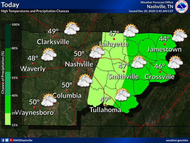
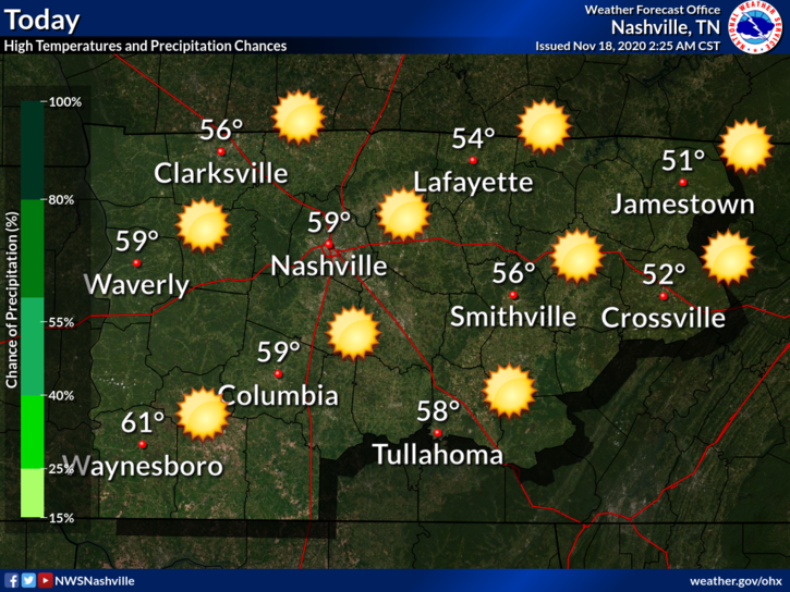
Overnight rain has moved out and we are left socked in with clouds. Good news is that we do start the warming trend today. Should top out around 50 today.

And it’s only going to get warmer from here…

Maybe touching 60 on Wednesday.

Now To The Good Stuff

First and Foremost – if you are looking for a blog hyping up a monster snowstorm for Middle Tennessee Christmas Eve, this isn’t the blog for you. We are going to keep it real and brutally honest.

(Editor’s Note: he means it)

Euro Model shows a batch of showers entering the area Wednesday Night into Thursday. Some of the rain could be heavy at times, especially before noon Thursday. A cold front is pushing this rain. All the rain will be ahead of the cold front.

Arctic air is behind the cold front. The question is (as usual when this happens here), will there be enough moisture left behind to turn to snow?

Well, maybe, just a little. The Euro model shows rain rain Wednesday night into Thursday morning. Then very light moisture behind it, with snow showers possible.

In this scenario, the cold air catches up to the moisture in time for *maybe* a quick dusting.

Other models agree that it’s going to get cold, but disagree on when that cold air moves in and if there will be any moisture leftover for it to interact with.

NWS Nashville explains it really well…

Behind this passing front, significant cooling is expected on Thursday, and especially Thursday afternoon/evening, as the closed low moves over the immediate vicinity. Thursday afternoon, temps should be cool enough to see a changeover to a rain/snow mix across the northwest [that’s not us]. Temps really plummet on Thursday night and any lingering precip likely to change to all snow. At this point however closed upper low will be moving to our east, and moisture will be limited. Thus we are not really setting up for significant snowfall. Thursday night into early Friday, the plateau could see an inch or so but elsewhere, trace amounts seem most probable. So some locations could have a dusting Christmas morning.

NWS Area Forecast Discussion 12-20-2020

We are “some locations” that “could have a dusting Christmas morning.”

This meteorological set up happens frequently in Middle Tennessee. Plenty of moisture, but air too warm, so we just get rain. By the time the cold air catches up, the moisture leaves.

charlie brown football pull GIF

Let’s assume we get this little bit of snow. What will it be falling on? The answer is a warm, wet Earth. We are going to approach 60° the day before. It is going to take time for the ground to cool off enough to accommodate snow.

That said, the air behind this cold front should be very, very cold. Timing on this may change but looks like we can expect freezing temperatures from around dark Christmas Eve until just before lunch Christmas Day, with the low bottoming out near 20° before sunrise Christmas morning.

But for the majority of you, even if we get a few flakes, or a flocking, that counts as a White Christmas.

Closing Thoughts

We are 3-4 days away from this event. We don’t know if the flocked trees are in stock. Forecasting winter weather in Tennessee is difficult the day of an event. Don’t believe “crap apps” that give actual accumulations this far in advance. And don’t give any clicks to clickbait social media posts that predict apocalyptic snowfall amounts by willfully misinterpreting model data. Trust the science and embrace the uncertainty. We will have much more on this event in upcoming blogs.

Sunny and Cold Before Rain Saturday Night, Warming Up Next Week

Chilly start to the morning with heavy frost and freezing fog in some areas.

We will surpass yesterday’s high of 40 for what that’s worth.

At least we’ll get plenty of sunshine

Another chilly night ahead. Near freezing with areas away from the city dipping back into the 20s.

The Weekend

Saturday starts out dry and pleasant. Afternoon temps nearing 50. Rain should hold off until after sunset.

Euro Model shows the best timeframe for rain between 9PM-6AM, although a light shower can’t be ruled out before sunset.

Models have been consistent in keeping amounts rather light.

Amounts under 0.25″ appear likely.

No washout and no severe weather

After the Rain

We won’t see a drop in temps after Saturdays system. Sundays temps will stay the same with a warming trend next week. Maybe touching 60 Wednesday.

Next chance of precipitation comes Wednesday-Thursday.

Peep the s-word in NWS Nashville Discussion…

This system more potent than our Saturday system and is expected to bring more widespread rain to the mid-state Wednesday, and more so Wednesday night as a cold front/deep moisture axis passes. This system also packing some very cold air, of which we will likely see either mixed precip or all snow before ending Thursday in many areas.

AFD 12-18-2020

This appears to be the classic setup of can the cold air catch up to what lingering moisture is left.

Editor’s Note: Winter Heartbreaker

We are 5-6 days from this potential event. Take raw model output and social media hype posts with mounds of salt. Something we will watch over the coming days.

Just for fun, here are the White Christmas statistics for Nashville.

Translation: Don’t get your hopes up

Rainy Saturday.

Many locations across Davidson/Williamson Counties dipped into the upper 20s this morning.

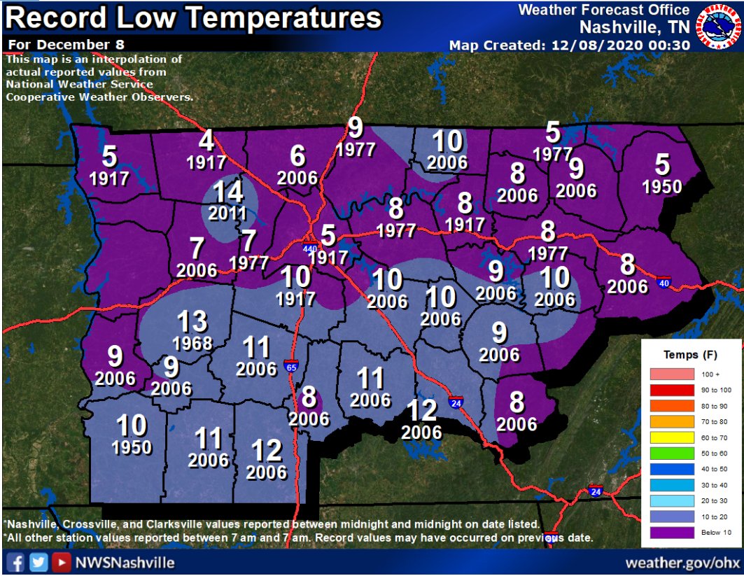
Trivia alert! In 1917 we set our record low, in Nashville and 10° in Franklin.

No record lows in sight.

Clouds may clear this afternoon before it gets dark. It’ll be close. Look for mid/upper 40°s.

Foggy Overnight/Early Weds Morning?

Fog is possible after midnight tonight into Wednesday morning. Skies will clear, the temp will drop close to freezing, and the dewpoint will be close to the temp. Winds at 5 MPH may prevent widespread fog but would not be surprised to see another round of fog or even isolated freezing fog where winds are calm. Here’s the hour by hour temp grid:

36-Hourly Temperature Forecast

Warming Up and Staying Dry

Wanting to get outside? You’ll have plenty of chances over the next few days.

Each day warmer than the next through Friday with bright sunshine.

Look at those 60s Thursday and Friday!

When and How Much Rain This Weekend?

Models this far out are low-res making data inconclusive about timing and amounts.

Euro Model shows rain to begin Friday night around Midnight to 6AM Saturday. Then off and on showers throughout the day, ending Sunday morning. This makes the most sense to us.

As for amounts…meh…

Forecast soundings PW’s for Saturday are crummy (sub 1″) which means we won’t get much rain out of this one and it looks like our next system could be 4-5 days after this one. That drought monitor might get a workout over the next couple of weeks.

NWS Nashville AFD 12-08-2020

PW means precipitable water. Low amounts of water in the atmosphere = low amounts of water reaching the ground.

Rainfall amounts from WPC through Sunday morning show 0.10″-0.25″ on the high end. That’s usually not enough to cause rainouts.

Bottom Line: Don’t cancel outdoor activities yet. Check back often for updates as higher-res models become available.

Sprinkles Unlikely Yet Possible Sunday Night/Monday Morning, Chilly Mornings, Then a Warmup

Most of the fog we had this morning has lifted. We even dealt with freezing fog…

Freezing fogs are not unusual. Light winds, clear skies, and dewpoints close to air temps provide perfect conditions for fog. Add subfreezing temps and a layer of ice can form. Probably too many clouds Monday morning for another round, but fogs and freezing fogs will be possible again Tuesday and Wednesday mornings.

Rest of Sunday

Partly cloudy skies in the early afternoon will give way to mostly cloudy skies in the evening.

Temperatures will be near seasonal averages with a high of 54.

Chance for Sprinkles

The weak upper level system responsible for the clouds might try and squeeze out some sprinkles late tonight and early Monday morning.

Euro Model predicts hardly enough to measure.

A few flurries are possible across the Plateau but we expect no local wintry activity.

Quiet Week Ahead

Not much to speak of this next week. High pressure will dominate and that will keep us dry for a while.

Upcoming morning temps will be a bit chilly values around freezing and even dipping into the upper 20s Tuesday morning.

We will warm up though, possibly into the low 60s by late week!

Next best chance of rain appears to be next weekend. Models predict a low pressure system will swing through the Great Lakes and drag a cold front across the entire eastern U.S., making rain ahead of it. The GFS model is below, but note this model run is a forecast tool, and model “accuracy” for local impacts as this range is poor.

Rain Tonight Transitioning to Splat/Melt Snowflakes Monday, Wind Chills and Temps Drop Below Freezing Monday.

  • Snowflakes mixing with rain possible while we sleep overnight. No accumulation.
  • More snowflakes possible again Monday mid-morning into the afternoon. Accumulation unlikely.
  • Wind chills will drop Monday into the 20°s.
  • Temps should drop below freezing Monday night around dark. Snow should have departed by then, but black ice may form on wet roads late Monday night/early Tuesday morning.
  • Check back in the morning and through the day for updated information.

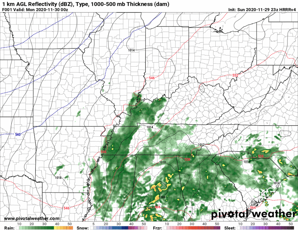
Rain will continue off and on tonight and overnight.

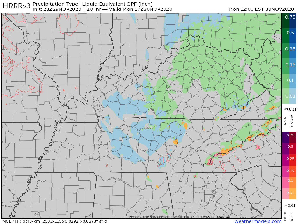
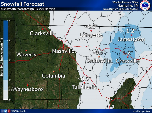
Forecast rain totals increased slightly from this morning. 1.00″ on average, but local rain gauges will vary. More rain is likely southeast (Nolensville, Antioch, College Grove, Franklin). Less rain is likely northwest (Bellevue, Bordeaux, Joelton, Fairview).

HRRR model total rainfall:

Rain should end Monday before sunrise. Sleet or snow may mix in with predawn rain. Most data (HRRR data below, for example) predicts surface temps will remain above freezing Monday morning. Any sleet or snow should splat/melt on contact.

Info you won’t get from your weather app

Officially 38° is forecast as the rain pulls away before dawn.

Monday After Sunrise

Low pressure will move off to the northeast. With it will go the bulk of the moisture. The “bulk” of the moisture. Not all of it.

North winds will spill in Monday and slice wind chills into the 20°s. Leftover precip will get caught in those north winds and rotate through Middle Tennessee during the day Monday.

What’ll happen next is a classic race between subfreezing surface temps chasing leftover moisture.

Surface air temps are expected to stay above freezing during the day Monday when flakes are expected to fly. This is not good news for snow fans. Surface temps above freezing mean any snow that falls would splat/melt. Daylight temps Monday are expected to be 33°-36°.

How could it snow with above freezing surface temps? Because temps way above us will be below freezing. Temps warmer here on the surface.

Freezing temps are not expected to get here until after dark Monday night. By then most, if not all, of the snow should have escaped east. But if the freezing temps can catch the moisture, we may see a dusting.

While we aren’t roadway engineers, we’ve been through these scenarios enough to know that pavement is warmer than grass/elevated surfaces. You will almost always see snow stick to grassy areas and elevated roads first. We aren’t expecting enough precipitation for snow accumulation on the roads (keep reading).

If you’re looking for accumulations…

The usual area of Jamestown-Crossville. Those fine folks know how to make the most out of a little moisture.

While accumulating snowfall isn’t a big concern, black ice is.

Temps will plummet into the 20°s Monday night. Wet roads will try to freeze. We hope fallen precip will evaporate during daylight hours and/or dry via that north wind. But be aware of bridges, overpasses, and areas that are shaded from sunlight. Wet roads can and probably will host black ice late Monday night into the wee hours of Tuesday morning. Predawn low Tuesday is 26°.

The Mercury alone is expected to fall into the low 20s. Start thinking about any winter prep you may need to do — water pipes, automobiles, checking on elderly, bringing pets inside, etc…

NWS Nashville AFD 11-29-2020

Note this forecast can still change. Weather models aren’t perfect and might be missing something important. Check back often for updates.

Departing words from NWS-Nashville:

More in the morning, and tonight/overnight as necessary.

Rain Tonight-Overnight, Snow Splat/Melt Monday (maybe a flocking?) with Bitter Cold Wind Chills.

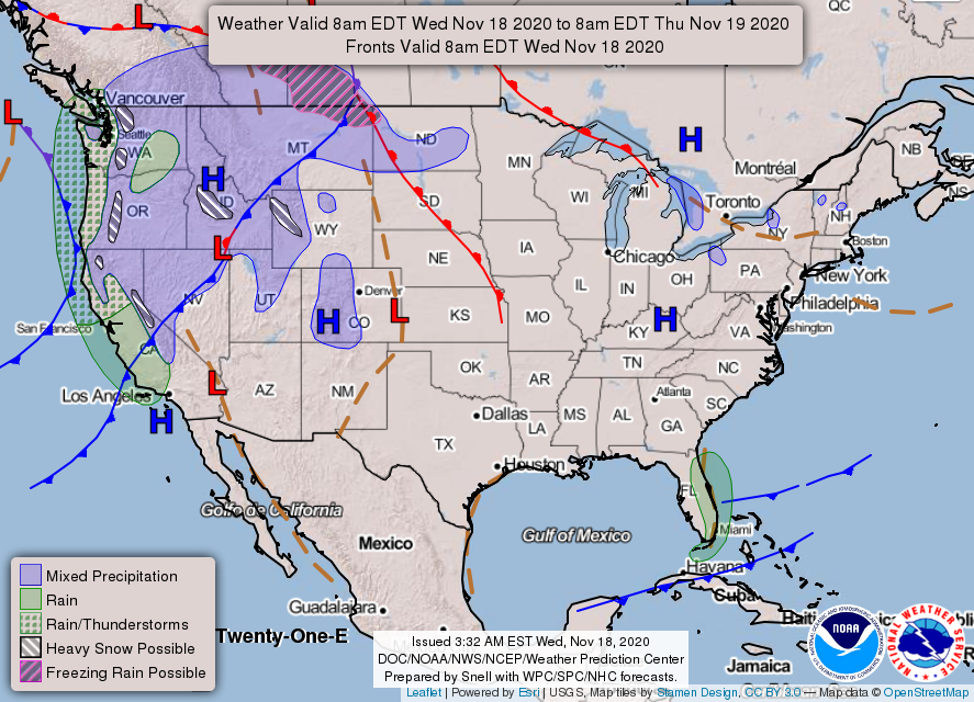
Our quiet November is about to change.

Sunday: All Liquid Precip

Daylight hours Sunday should be dry. Rain expected around sunset or shortly thereafter.

Euro Model shows a 6PM start time.

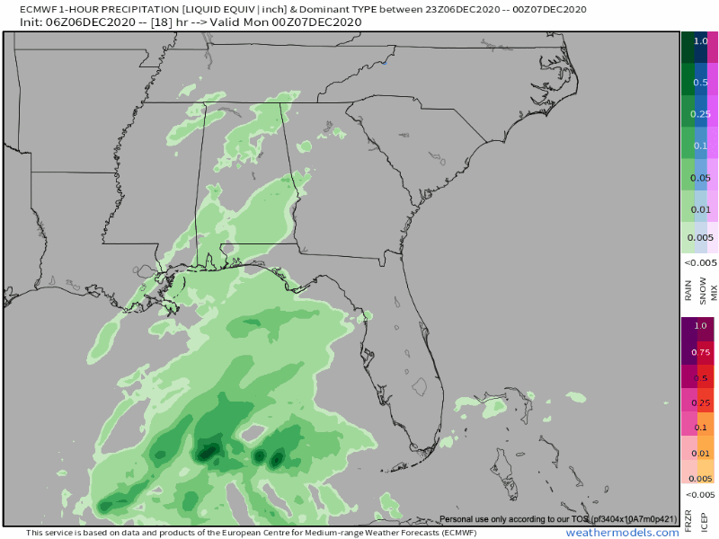
This is a soaker. NWS-Nashville lists 0.75″ but that’s an average. Data suggests more rain southeast (Nolensville, Antioch, College Grove, Franklin) and less rain northwest (Bellevue, Bordeaux, Joelton, Fairview), but that line could shift a bit here or there and give everyone 1.0″ or 0.5″ or less. Some may see more than 1″. We’d rather see less rain to limit the potential for black ice Monday night into Tuesday morning. Here’s the HRRR model total rainfall:

A few flakes are possible before sunrise Monday morning. HRRR data (the two images below) shows snow may form aloft where the model thinks temps will be exactly 32°. If that’s what happens a snow or sleet event might happen; however, at the surface we’ll still be several degrees above freezing so anything that hits should splat, melt.

Monday: Liquid/Frozen Precip

Many apps and national maps (like the one below) show snow and mixed precip for Monday:

Here’s what’ll be happening after the pre-dawn rain Monday stops.

Low pressure responsible for the rain will pull away to the northeast. Cold, drier air will filter in behind the departing low. We’ll feel that cold, drier air for sure. North winds 12-16 MPH will slice wind chills into the 20°s all day Monday.

Light precipitation will get caught in north winds. Precip should spread into Middle Tennessee during the day and potentially into the night Monday.

Surface air temps are expected to stay above freezing during daylight hours Monday while this light precip moves through. We’d need freezing temps (32°) throughout the atmosphere in order for snow to accumulate and it doesn’t look like we will get them. You’ll have to go east for that. While precip may fall as snow, or sleet, or a mix, it’s expected to hit the ground and melt.

This is because surface temps are forecast to be between 36° and 32° during the day Monday.

Roads will be warmer than the air around it. That’s why we see snow more likely to accumulate on grassy surfaces, garden gnomes, decks, and mailboxes, but not the road.

While the difference between 32° and 34° may not seem like much, in winter weather, one degree means either a cold rain or some flakes.

Surface temps will reach freezing Monday night. Any leftover precip might make a dusting on grassy areas, but quickly Monday night the snow will follow the low east.

Euro Model, below, shows the entire event. Rain, a few flakes, then by Monday night all precip races east.

The big concern isn’t any accumulation (not expecting any) but the black ice potential as temps dive into the 20° around midnight Monday night. The pre-dawn low Tuesday is 26°.

Right now it looks like temperatures may cool enough to see some snowflakes mix in with rain over much of the mid-state Monday morning and afternoon. but accumulation is unlikely for areas west of I-65… Temperatures will plunge into the mid 20s Tuesday morning as the upper trough axis passes overhead.

NWS Nashville Discussion 11-29-2020

Any residual moisture on the roadways will try to freeze, first on bridges and overpasses. This should happen Tuesday morning. The good news is Monday we think there will be around 10-12 hours of daylight and a steady wind, which should help the drying process. But black ice formation early Tuesday morning is still a concern.

Also make it a priority to look after those furry friends. If it’s too cold for you, it’s definitely too cold for them.

So, bottom line, maybe just a flocking, but you’ll need to go east to see anything good.

Check back frequently for changes and updates. We’re talking about weather models and a degree of difference here or there. You should pay attention.

We will warm up to near 50° by midweek, just in time for another rainmaker Thursday. We’ll be talking about snow then, too, but one thing at a time. (No, that one also doesn’t look like a big deal).

Finally, we have new merch. Use the coupon code HOLIDAY for 15% off until Sunday at midnight. New sweatshirt, new scarf. All proceeds fund @NashSevereWx. https://nashvillesevereweather.com/shop/

Gradual Warming Trend Into The Weekend, Next Rain Event: Sunday Night/Monday Morning

Few degrees warmer than Tuesday with a high approaching 60 and bright sunshine.

Wash Away!

Notice the “Blue H” over Kentucky.

If you’re a dry weather fan, that “H” is your friend. It prevents air from rising, which is how showers and thunderstorms form.

Good news is that high pressure will stick around through Sunday.

SFC/LL high pressure will remain in control well through the weekend, as well as upper ridging which builds later today. This will give us dry condition with those warming temps through most of Sunday.

NWS Nashville AFD 11-18-2020

And that warming trend…

Highs near 70 this weekend!

Rain Returns Late Sunday/Early Monday

Models have come into better agreement with the timing. Both the Euro and GFS predict a late Sunday/early Monday morning event.

Euro Model

Best guess ETA this far out appears to be midnight to 6AM Monday morning. Expect changes to this as higher-resolution models become available.

Good news: We don’t expect this to be particularly heavy nor do we expect any severe weather.

For now, get outside and enjoy these dry days.

Rain Saturday Night/Sunday Morning, Dry Afterwards

Perfect Saturday

No rain during the day. Mostly sunny and 70!

Couldn’t ask for a better November day!

Details on the Rain

A wind advisory has been issued for the overnight hours.

A cold front will swing through overnight. Showers and possibly a thunderstorm will accompany it.

ETA? HRRR Model predicts a broken line of showers between 2AM-7AM, although a stray shower before then is possible.

How much? Not looking at any significant totals, 0.10″-0.25″ likely. Individual rain gauges will vary.

Severe Concerns? We don’t think so and neither does NWS:

Jet structure ahead of the front really strengthens tonight, as helicity values shoot way high and 0-6km bulk shear pushes 50kts. But as with the last few runs of several different models, virtually no instability showing up… Even without any good instability, parameters are there for isolated storms.

NWS Nashville AFD 10-14-2020

No storm fuel means no severe weather. SPC has the tornado probs well to our west.

Non-thunderstorm winds will be a factor though. Gusts of 30-35mph are possible.

Good News

Rain should move out by mid-morning leaving the rest of Sunday dry with a high of 63. Perfect for raking the leaves blown down by the gusty winds.

Dry and Cooler Next Week

No rain expected the entire week but it will feel much more like fall. Upper 50s for highs Tuesday/Wednesday with near freezing temps Wednesday morning.

For now, have a great weekend!

Sunny, Warm, then Mid-Week Rain.

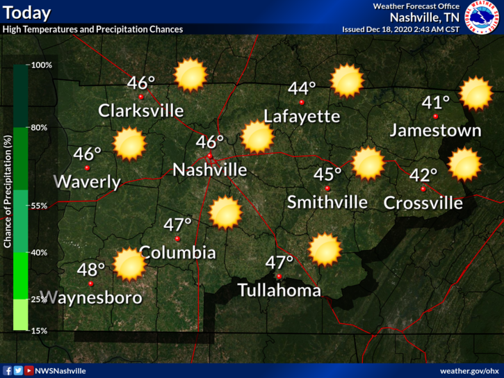
Patchy morning fog gave way to sunshine.

Look closely and you’ll see the swirl of Tropical Storm Eta near Cuba!

We hit the record high yesterday of 80!

We’ll probably come a few degrees short of it today. Forecasted high is 81 while the record is 83 (2005). Perfect for a noon kickoff. Don’t think the visiting Bears will mind.

Few more clouds Monday but that’s about it. The November warmth continues with a high near 80.

Welcome Back Rain

An approaching cold front from the northwest along with help from Eta will spark some showers and maybe a weak thunderstorm (no worries).

Rain ETA as early as noon Tuesday with a departure around noon Wednesday.

Models agree more with amounts than timing. Euro (above) wants to keep moisture around a little longer than the faster GFS.

Doesn’t look to be a washout. 0.1′ to 0.25″ on average. Locally higher amounts are possible with any overachievers. This rain should be spread out over 18-24 hours so it may not rain you out.

In short, Wednesday looks drier west of I-65 and wetter to the east. WPC QPF through Thursday morning is reflective of the slowing frontal boundary… Nashville Metro and areas west may only receive 0.10″-0.50″. A rumble of thunder cannot be ruled out, but organized thunderstorms are not expected.

NWS Nashville AFD 11-08-2020

Cooling Off

Temperatures will cool a bit beginning Wednesday night when the cold front passes and a north wind takes over. Upper 60s for highs with a return to mornings in the 40s.

More rain is possible next weekend but details are pretty fuzzy (maybe Saturday?). For now, enjoy these November 80s!

Warming Up and Staying Dry

https://twitter.com/matthewlawsontn/status/1323961298447704072?s=20

Exactly!

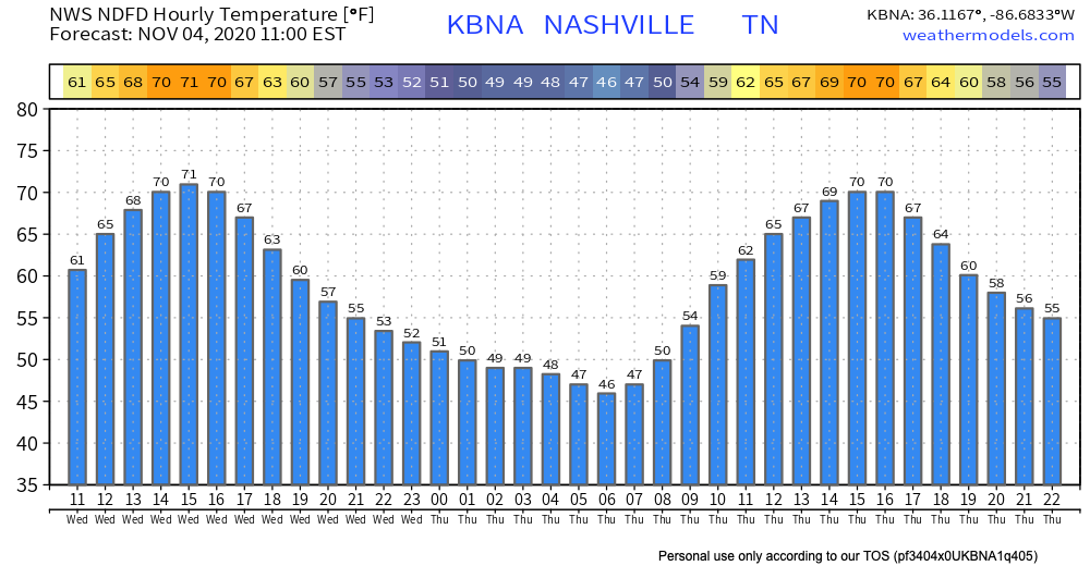
High of 71 in November is perfection. It has been a nice day!

We will cool off tonight to the mid 40s. Check out the hourly temperature forecast:

“Big Blue H’s” make meteorologists lives very easy.

Might see a few clouds… yawn.

Warming Up

This is the big story for the next several days. If low 70s doesn’t do it for you, try mid-upper 70s!

Any Rain?

If you like the warmer November temperatures, you’re also going to like this: it may not rain until next Tuesday, at the earliest.

NWS Nashville AFD 11-04-2020

It’s not uncommon to see dry spells this time of the year in Middle Tennessee.

Not Beta or Zeta but Eta

Eta made landfall yesterday in Nicaragua as a powerful category 4 hurricane. It is forecasted to be a depression as it moves through Central America and then get back out into the Caribbean Sea.

It it too early to say whether or not this will impact the U.S. For now, this doesn’t appear to be a rainmaker for Middle Tennessee.

We will of course keep you updated. For now, enjoy these warm, dry conditions.