Off-and-On Rain (Low-End Severe Threat) This Evening, Active Next Week

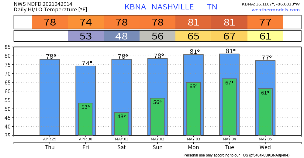
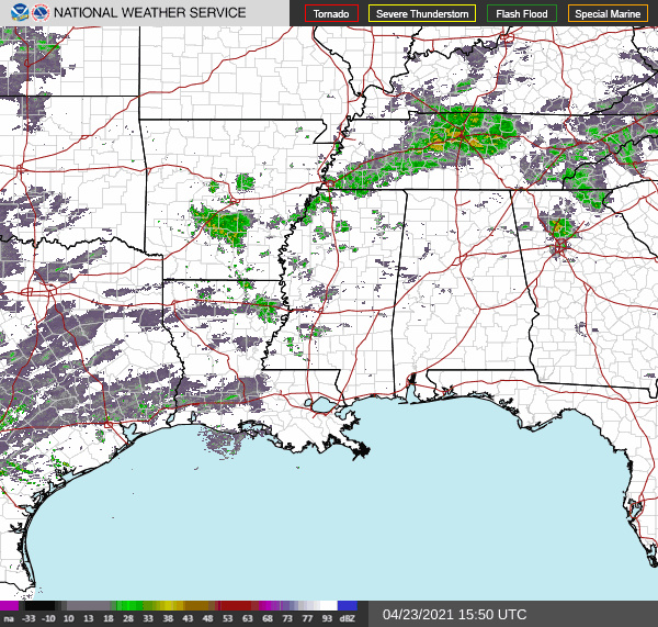
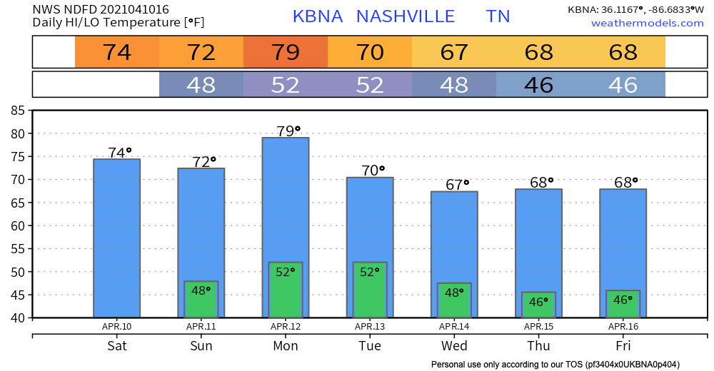
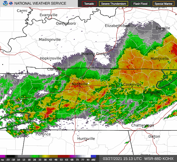
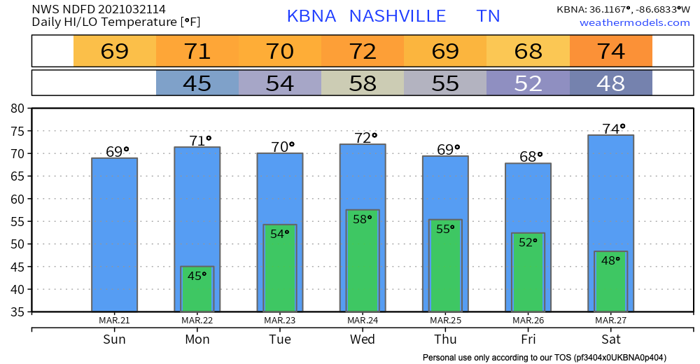
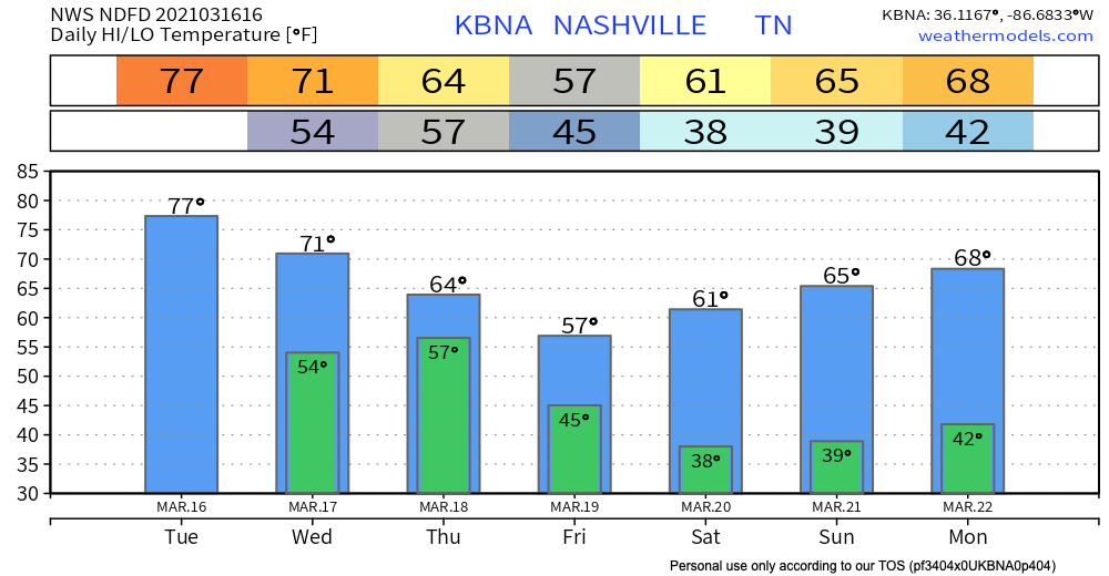
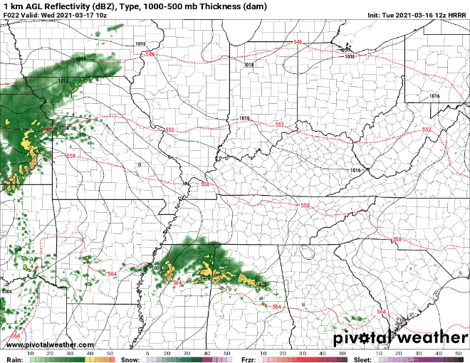
Steady, light rain has overspread the area

Models aren’t good enough to determine whose track field will get rained out at what time.

But, really, the HRRR thinks this rain is going to hang around for the evening with several rounds of showers and maybe a storm. HRRR through midnight…

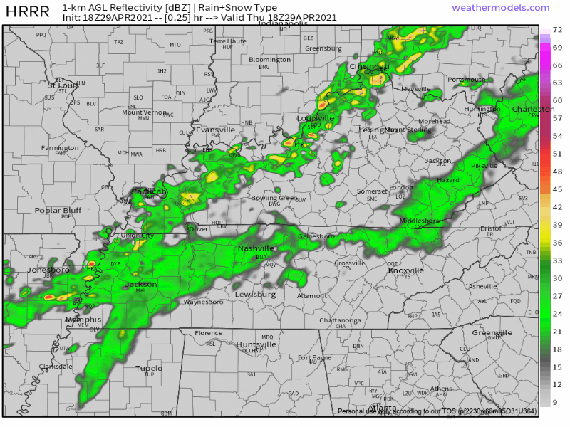
More isolated showers/storms should develop around rush hour. These could be a bit stronger than what we have seen this morning. read more

Rain Likely Saturday (will it rain-out sporting events?) Then Warm/Dry Weather Returns

Scattered showers are affecting parts of the Deep South this afternoon, including here in Davidson/Williamson Counties.

You may experience some heavy downpours but nothing more than that.

This activity should end early this afternoon with highs reaching the mid-upper 60s. read more

Shorts, Snow, Wind, Rain, Warmup: Every Season Gift-Wrapped Into One Blog

Probably not the April gift y’all were looking for.

Light Showers (maybe a NBD snowflake) Tonight-Overnight

Yes, a snowflake may mix in with the rain and make it to the surface. After midnight ETA. It’ll splat melt.

No, you should not panic buy milk and bread (for milk samiches). read more

Hit-or-Miss Showers This Afternoon, Cooler and Dryer Next Week.

Storms last night weren’t as strong as we thought they could’ve been… be thankful.

Areas to our south weren’t as lucky…

Back to Tennessee

Rain that we experienced overnight and this morning has shifted east for the most part. read more

Rain (Maybe Storms) Late Wednesday, More Rain Possible Saturday

Perfect spring weather persists Tuesday.

Next Weather Maker: Late Wednesday

Most of the day Wednesday should be dry. The bulk of the activity will come during the overnight hours Wednesday Night -early Thursday Morning

HRRR Model shows a weakening line of showers moving entering our western communities around midnight Wednesday night, with most of the precip ending before sunrise Thursday. read more

The Warm-up Begins, Next Rain Event: Mid-Week (Storms?)

Was this the last freezing morning of the szn?

Place your bets. We say “probably” because it’s difficult for the atmosphere to get freezing air this far south, this time of the year, but not impossible. For now, we see no chance of a freezing morning for the next 7-10 days. read more

“Goodbye Stranger”. Drying Out and Winter’s Last Hurrah?

Our thoughts exactly!

Even though the rain has departed, flooding still remains a concern, especially if you live near the Harpeth River in Bellevue. If you come across a road with water over it, please do not attempt to cross is. It’s difficult to judge how deep the water is and it doesn’t take much to cause big problems. read more

Dual-Threat of Flash Flooding/Severe Storms. Stay Connected Today/Tonight!

Join Us On YouTube Live!

Back To Your Regularly Scheduled Content

Storms this morning packed a punch with gusty winds, heavy rainfall, and hail.

Current radar shows sub-severe rain over the area. Unfortunately, this will only exacerbate the flooding concerns.

HRRR Model below shows off and on showers this afternoon before perhaps a more substantial line of storms rolls through overnight. read more

Showers Possible Tuesday-Wednesday, Storms Thursday?

All these upper 60s-low 70s have us feeling:

Few Showers Tuesday-Wednesday

An upper level low will pass through the midwest Tuesday. This should spark some off and on rain Tuesday, maybe into Wednesday.

But the data isn’t giving any clues to timing. It’s possible all the rain misses your backyard. read more

Severe Storm Potential Wednesday: Risks, Timing, Uncertainties

We will likely see two round of rain/storms Wednesday.

The first round will move through during the late morning and early afternoon hours.

This first round will race ahead of the warm front trailing behind it, so while gusty winds are possible, tornadoes are not expected to accompany this activity. read more