Scattered Storms This Afternoon; Ida Starting Monday

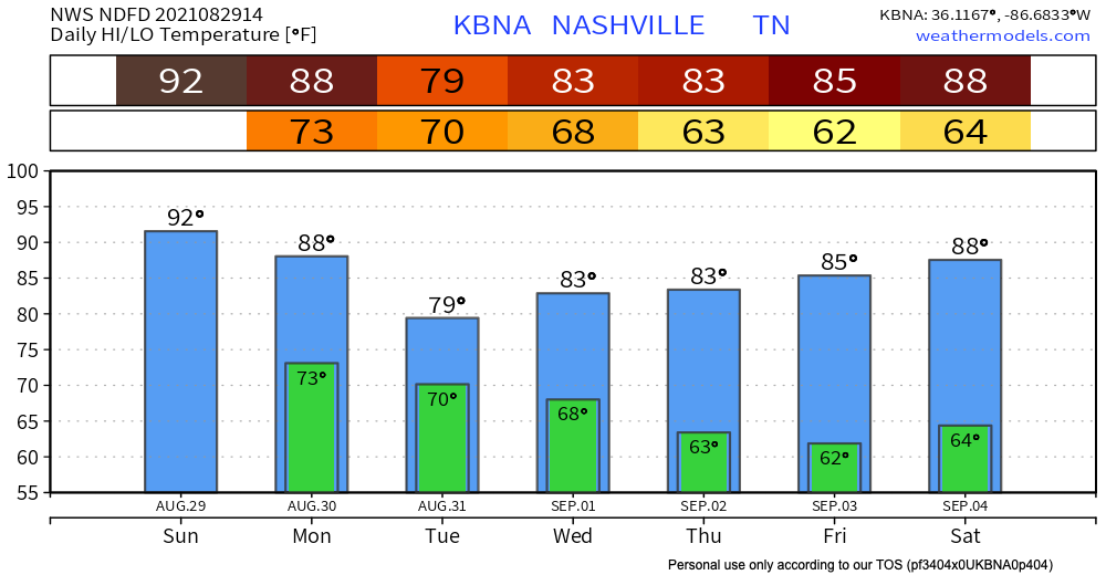
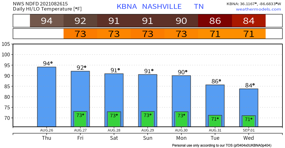
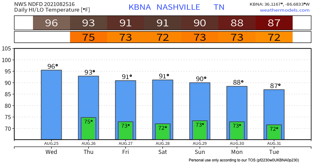
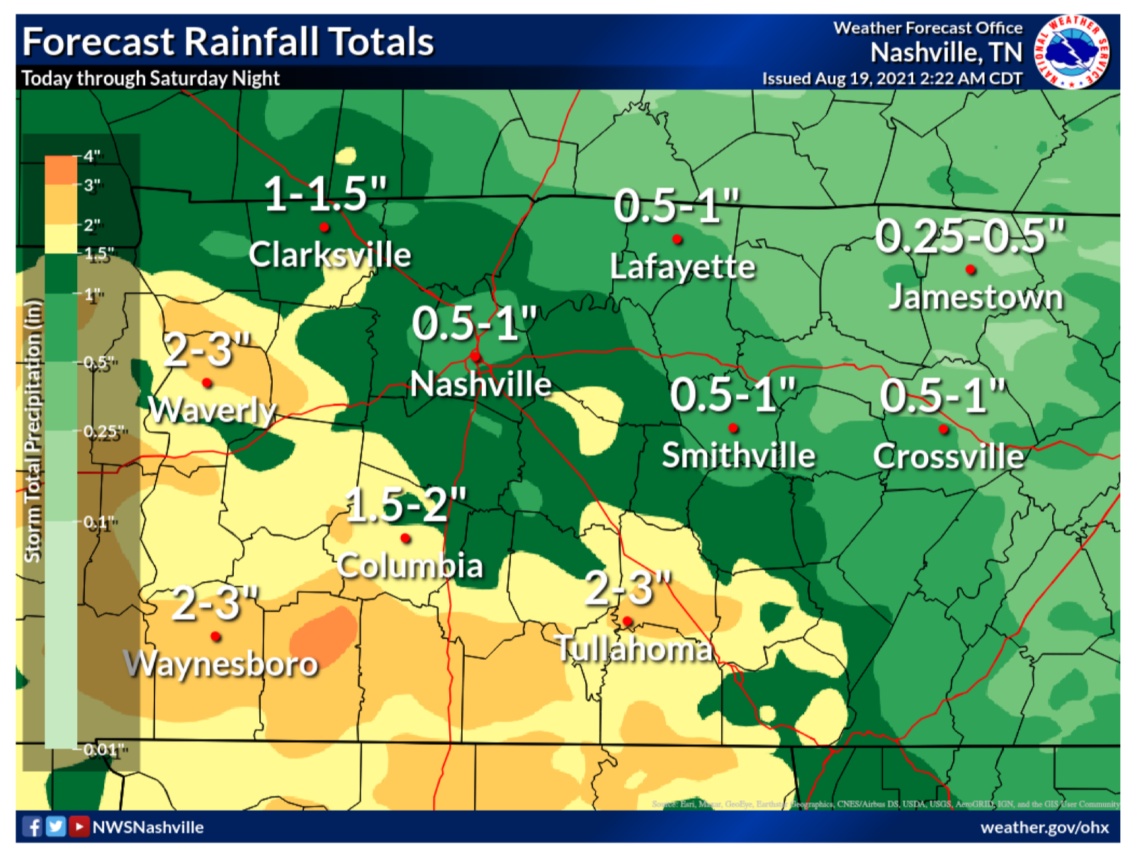
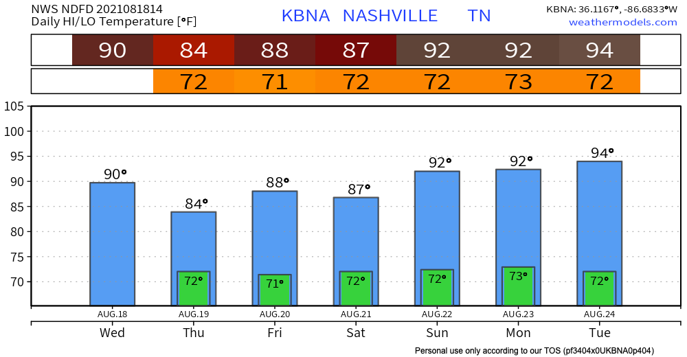
Isolated showers and storms this afternoon-evening are going to leave us feeling a little muggy. Highs in the low 90’s and dew point in the low-mid 70s.

Ida will cool us off then. High’s will be down in the 80’s for the rest of the week eventually dropping dewps to the mid 60’s by Wednesday. read more

Copy and Paste for the Weekend

If you read yesterday’s blog then today will sound familiar. High’s in the low-mid 90’s and dewps in the low 70’s making it feel like 100 degF. Afternoon showers and thunderstorms roll in mid afternoon. No severe weather is expected out of these storm pockets. Always be prepared for lightning and possible high wind gusts. read more

Hot + Isolated Afternoon Storms

Isolated storms pop into our area starting around 1pm. After 7pm the show seems to be over and any rain stays to our east, see HRRR below. Only threat in this bunch of storms is lightning.

High temps in the mid-90s combined with dew points in the low 70s will make it feel like 101 this afternoon. read more

Storms Today; Local Flash Flooding Risk

Storms don’t reach our area again until 1-2pm. These won’t be as widespread as yesterday. Only threats with this batch is lightning and wind gusts. No severe weather is expected. Scattered storms continue into early Friday morning, see HRRR below. read more

Lightning Storms With Straight-Line Winds Possible Today/Tonight

The Storm Prediction Center believes there’s a 5% chance you will see damaging straight-line wind within 25 miles of you today and tonight. While the threat is low, it is not zero. Two of our communities have seen the affects of microbursts recently, Oak Hill and Nolensville. Will we see another one today? We don’t know. But, the chance is there and worth noting, especially if your plans include being outdoors. read more

Dry with Temps and Humidity Rising

Pretty Great! Tiny Rain Chance Tomorrow. Weekend: Less Great.

The trend continues! High’s in the upper 80’s today until the weekend. Not expecting any precip today and dew point lingers around 60 woohoo!

Wednesday: Smoke? Rain??

The smoke from the wildfires starts to move out today. Throughout today the yellow line of smoke moves south and out of our counties for a clearer tomorrow shown by HRRR below. read more

The Heat Continues!

Not a super wet Tuesday with only a couple scattered showers for this afternoon/evening. HRRR has storms popping in late afternoon and should be out of the area by 9pm. These storms may include lighting so lookout for that. Also expect quick downpours and gusts of winds. Will you get rained on? No one really knows. Rain is more likely south of 40 than north of 40. But either area could get rained or stormed on. read more

No Rain Today, But Western Wildfire Smoke. Air Quality Health Advisory

We have reached the end of the rain! We’re staying dry for today and tomorrow. Any blips of storms on the models stay south of us. There is not much of a chance for those to develop throughout the afternoon time and affect us. read more

Beginning of the End for Steady Rain, Here Comes the Heat & Humidity

Rain continues south of us today. We may see an upper level low spin a few showers in here this afternoon along and south of I-40. Nothing like yesterday, though. Here’s the HRRR model: