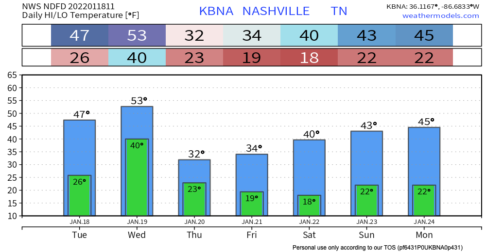
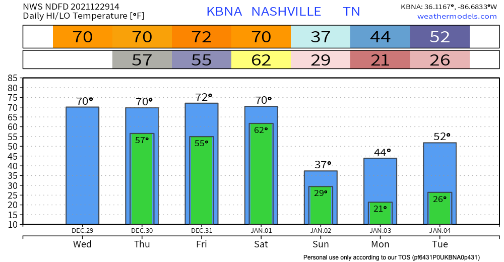
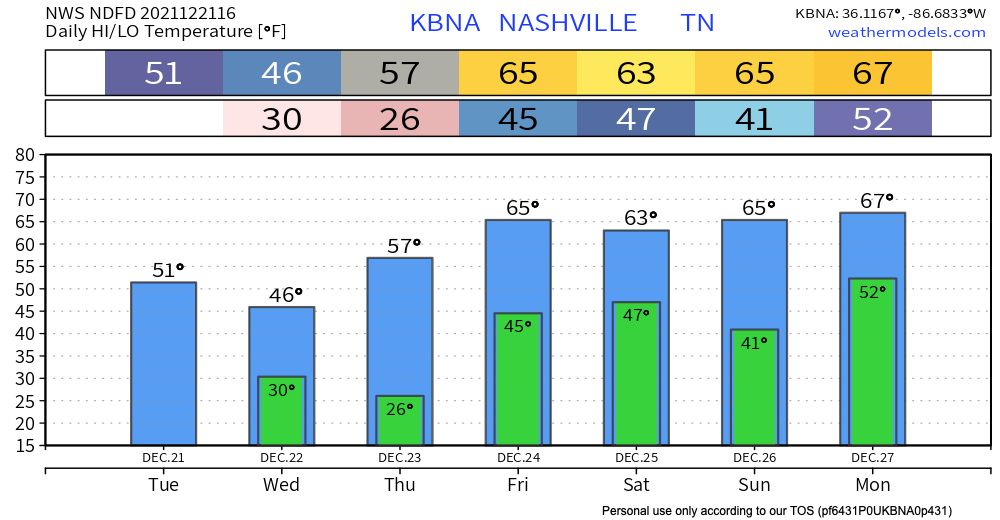
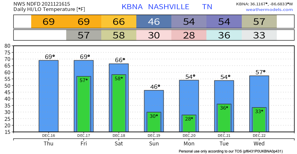
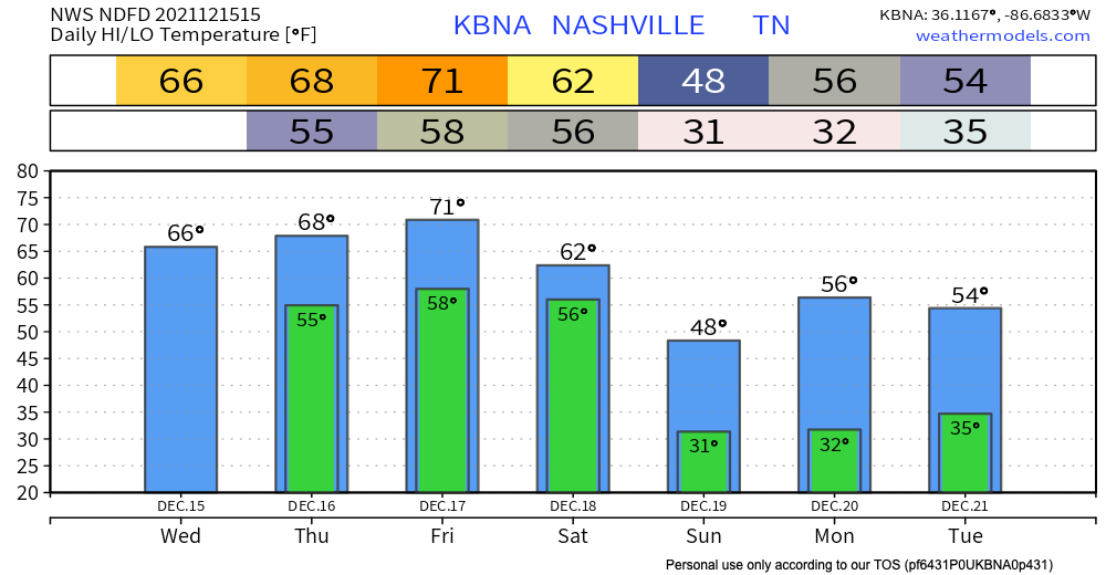
Freezing fog has already formed early this morning. A dense freezing fog advisory is in effect until 9am this morning. Some extra time for your morning commute may be needed. Patchy black ice is still a road hazard to look out for this morning. Overpasses, areas of elevation and neighborhood/back roads can have hazards stay around longer due to slower melting. Temps get up to the high 40’s today so significant melting is on the way as we go throughout the day.
Author: Megan Hanna
Rain to Snow System Wednesday.
Temps get up to the mid 30’s today. Melting will be slow. Expect a refreeze tonight as temps dive into the low 20’s. This may continue dangerous road conditions into the morning commute tomorrow, especially in elevated areas and on secondary/neighborhood roads. Highs tomorrow in the upper 40’s will bring significant melting.
Dry Until Possible Showers Thursday; Wintery Mix Saturday into Sunday?
Normal January temps are really sticking. Today and tomorrow will stay dry and cool with overnight lows dancing around the freezing mark.
Our area could see some showers Thursday. Euro model below shows some of us getting sprinkles in the afternoon time. GFS has any precipitation staying clear of our area. If this system lingers and ends up in our area later that night, a flurry may be in the mix. Chances aren’t high, so for now expect some sprinkles.
Sunny and Dry Most of the Week
Hard Freeze Tonight + Snow Again Thursday?
Severe Storms Possible Today + Starting Off The New Year With Severe Weather?
SPC places a greater severe weather chance south of I-40. The majority of our counties are still included in the slight risk category for today’s severe thunderstorms.
The main threat is damaging straight line winds (60+ mph) with a 5% chance of damaging winds/gusts within 25 miles of you. A tornado can’t be ruled out in this situation with a 5% probability of a tornado within 25 miles of you. Small hail is possible with a 5% chance of hail with a diameter of 1 inch or greater within 25 miles of you.
Cooling Off Till Wednesday; Dry Christmas As of Now
Latest Tornado Tracks; Rainy Start To The Weekend
Dry Today, but A Wet Couple of Days Ahead
We stay dry and experience above average temps today getting into the upper 60’s. A wet couple of days are ahead, although we don’t think everyone will get rain non-stop all weekend. Thursday scattered showers and possible thunderstorms start in the afternoon. These are not expected to bring severe weather. Quick downpours can cause some potential flash flooding. WPC is forecasting a 5-10% chance of flash flooding occurring within 25 miles of you. So, keep an eye on the possibility of flash flooding becoming a problem if you live in a flood prone area.
Warming Up + Severe Storm Chances Saturday
We’re staying dry and getting up into the low 50’s today. The sun stays until Friday. Temps heat back up to the low 70’s by the end of the work week.
Severe Storms Possible Saturday Morning
A cold front is forecast to come through Saturday morning that has the potential to bring some severe storms our way as it pushes through. The SPC has everyone west of the Cumberland Plateau in a severe weather outlook for Friday. Our counties are in a slight risk (2/5 scale) for severe weather. This translates to a 15% chance of severe weather occurring within a 25 mile radius of us. Main threats are damaging winds along the front as it comes through (60+ mph) and isolated tornadoes.