
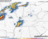
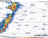
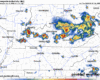
As of 1:15p, there’s a line of showers/storms just off to our west. We’ll be watching how that behaves, and any potential development behind it.
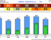
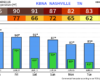
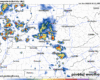
The Storm Prediction Center has our counties outlooked with a 5% chance of damaging straight-line winds within 25 miles. We are not included in any probabilities for hail or tornadoes. Although I reckon it’s feasible a strong storm could produce some sub-severe sized hail.
You must be logged in to post a comment.