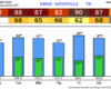
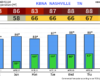
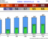
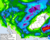
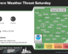
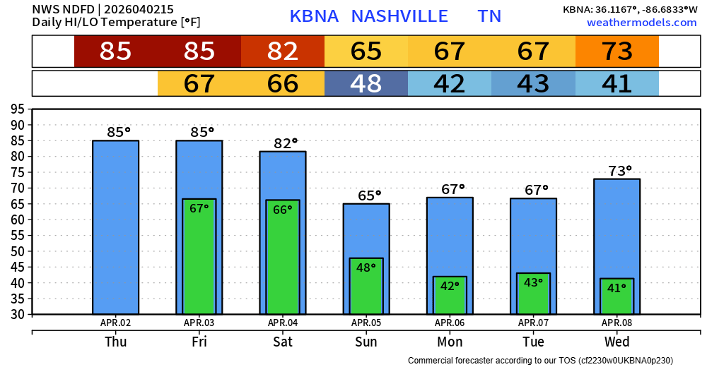
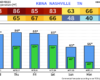
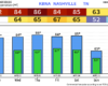
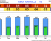
Wet Week Ahead, Iffy Eclipse Viewing Tomorrow

Storms in West TN will slowly make their way over tonight. Thankfully, they should lose their steam and we are not expecting any severe weather tonight.

HRRR model (above) has an ETA of around midnight tonight. You may hear a rumble of thunder, but no worries. Rain should exit before Monday AM rush hour. read more

Frost Advisory Tonight, Unsettled Pattern Begins Sunday.

Good idea to cover up plants tonight, a Frost Advisory will be in effect from 4am thru 9am Saturday morning.

Lows are expected to get down into the low 30s, thankfully temps will quickly recover Saturday afternoon and make it into the low 60s. read more

Frost/Freeze Possible Tonight and Friday Night, Rain Chances Return Sunday.

Temperatures will dip into the mid 30s tonight, which may bring some frost to the area. A few backyards may dip below the freezing mark.

Friday high temps will reach the upper 50s, but Friday night will have our coldest temperatures of the forecast, with temps in the low 30s. A few places may get down into the upper 20s. Good idea to cover up any loved plants. read more

Frost/Freeze Possible Thurs/Fri Night, Looking at Eclipse Cloud Coverage.

Pockets of on/off rain continue to move thru the area, coverage will decrease as we head into tonight. Still can’t rule out some more brief graupel/small hail aka Sonic ice in some of the showers. read more

All Clear. Cool Rain Possible Wednesday + Thursday.

The cold front has passed through, bringing in cooler air and signaling the end of our severe weather threat.

High temperatures Wednesday – Friday will be about 20° cooler than we experienced today. Gross. read more

New Info on Timing, Hazards for Tuesday’s Severe Weather Threat

The Storm Prediction Center came out with their midday update for Tuesday and have upped our probabilities for severe weather tomorrow.

Both counties are outlooked with a:

  • 10% chance of a tornado within 25 miles (some of which could be strong, EF2+)
  • 30% chance of damaging straight-line winds within 25 miles (some gusts could be hurricane force, 74mph+)
  • 30% chance of severe hail within 25 miles

These probabilities are subject to change. read more

Update on Tuesday’s Severe Weather Potential

Overnight, the Storm Prediction Center increased our probabilities for severe weather on Tuesday.

Both our counites have been outlooked with a:

  • 30% chance of damaging straight-line winds within 25 miles
  • 15% chance of severe hail within 25 miles
  • 10% chance of a tornado within 25 miles

These probabilities could change. The Storm Prediction will update these several more times between now and Tuesday afternoon. read more

Discussing Tuesday’s Severe Weather Chances: Timing, Hazards…

Very nice Easter day going on.

Monday will be another warm and probably dry day. Overnight Monday we could see a few showers/storms, but the majority of the activity should stay to our north.

Our main focus continues to be the threat of severe weather Tuesday. read more

Warm + Dry Weekend, Still Watching Tuesday.

Today’s high temps have soared into the upper 70s, Easter Sunday and Monday will be similar temperature-wise. A few places may even surpass 80 degrees.

We should be dry through Monday, a few showers cannot be ruled out Monday morning, but majority of us will stay dry. read more

Beautiful Easter Weekend, Eyes Still on Tuesday.

Wonderful weather today and the rest of the weekend.

No rain expected thru Sunday, and we’ll likely stay dry Monday as well. Highs nearing 80° Saturday – Monday. Great weather for all the outdoor activities, egg hunting. read more