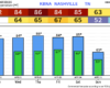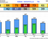
If you thought March felt abnormally warm – you’d be correct. It was actually the 2nd warmest March on record with an average temperature of 60.3° (warmest is 61.1° in 2012).
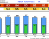
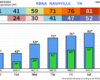
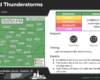
No April Fools jokes here – just high temperatures continuing to be ~20° above average.