
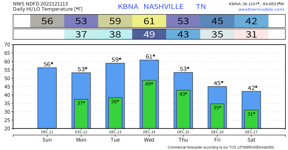
Temperatures will be fairly consistent for the next five days or so. Highs in the 40’s, lows in the mid to upper 20’s. That’s cold, but pretty average for this time of the year. Not really any meaningful chances for any precipitation, the GFS shows some showers on Monday, but other models think it’ll be too dry.
Elan
Just One More Rainy Day To Get Through, Then Cold and Dry

It has been a wet, damp, moist, whatever word you want to use to describe this morning, and it is only going to continue throughout the day.
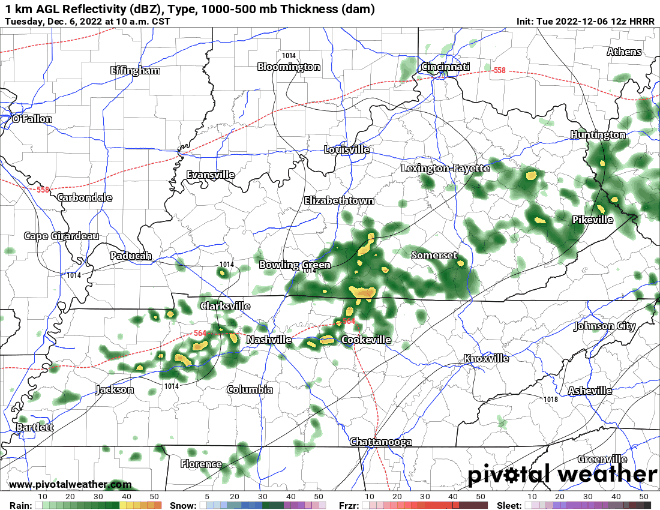
The HRRR model (above) shows on/off rain really all day, before the rain finally pushes east of us at around 11pm, give or take an hour or so.
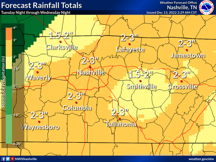
Heavy Rain Starts Tonight, Drying Out For The Weekend
Today will be a nice day as high temps reach the 60° mark. Cloud cover will move in as the day goes on.
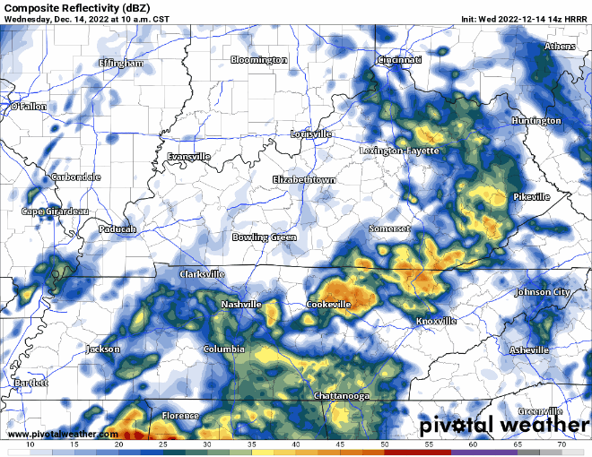
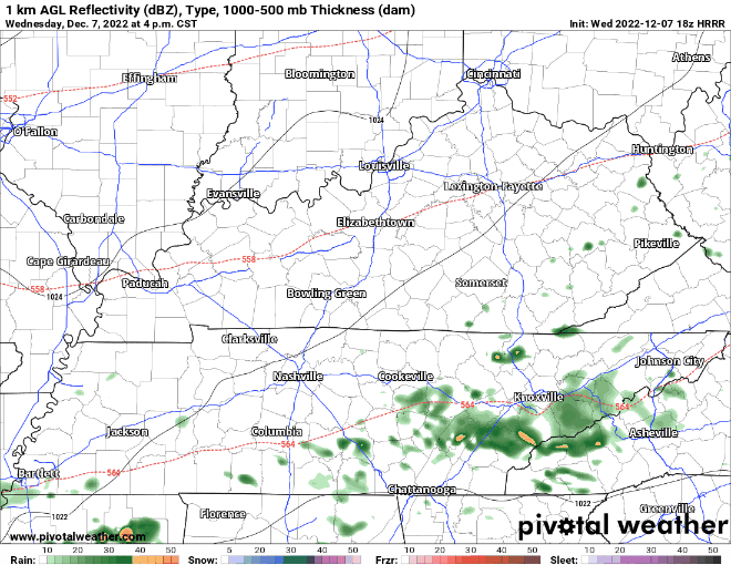
The HRRR model (above) shows two rounds of rain for Wednesday. The first one beginning in the wee hours of Wednesday morning, hopefully clearing out by AM rush hour. The rain resumes around noon and continues through Wednesday night.
Heavy Rain For Wednesday, Then Cold Air Settles In
Not too bad of a day today, hoping the sun can peak through later, but cloud cover will dominate for the majority of the day. No rain.
Tuesday will be pretty much a repeat of Monday, except for high temps should be able to reach 60°. Can’t totally rule out some sprinkles during the afternoon, but the majority of the rain should hold off until after midnight on Wednesday.
Two Dry Days, Then Back To Rain
Today and Monday will be relatively nice days, with highs just a tad above normal, but most importantly, no rain. Clouds will eventually clear out at some point this afternoon.
Tuesday looks the be dry for the most part, until rain moves in late Tuesday night, as shown below by the EURO model.
Can’t Shake The Rain Chances
Heavy rainfall this morning caused some streams and creeks to rise, along with some minor flooding in low lying areas.
There is still a Flood Advisory for the SE portion of Williamson County until 3:45pm. If you come across a flooded road, turn around, don’t drown. You can also report any flooding you see in a tweet with #tspotter.
More Rainy Days Ahead

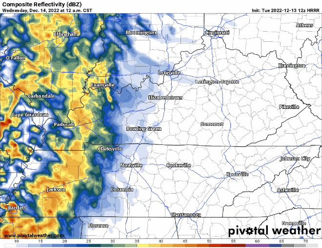
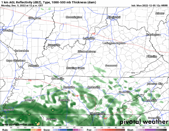
The wet week continues this morning, and will continue on and off throughout the day and into tomorrow – as shown by the HRRR model below.
- Rain will continue on/off throughout the week until Friday afternoon or evening – when most models expect us to clear out.
- Much lower rain chances for this weekend
- Overall rainfall totals continue to come down – only 1-2″ more inches expected, maybe some locally higher amounts. NWS Nashville thinks the overall risk of any widespread flooding continues to decrease.
- You may hear a rumble of thunder or two, but no severe weather is expected this week or into the weekend.
- Rain chances increase on Monday/Tuesday – more deets on that in the upcoming days.
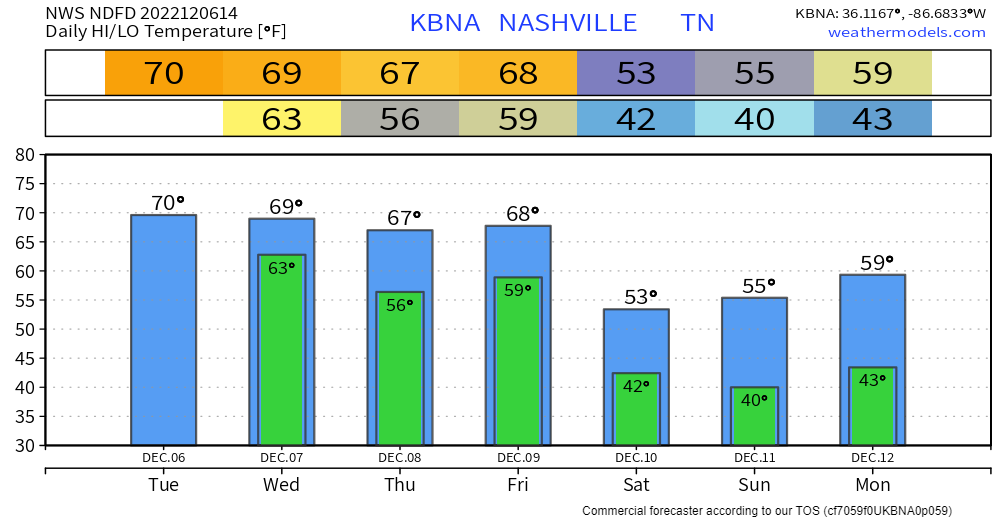
Above average temps continue throughout the week, cooling off to what we are used to for this time of the year by the weekend.
Rainy Week Begins Today
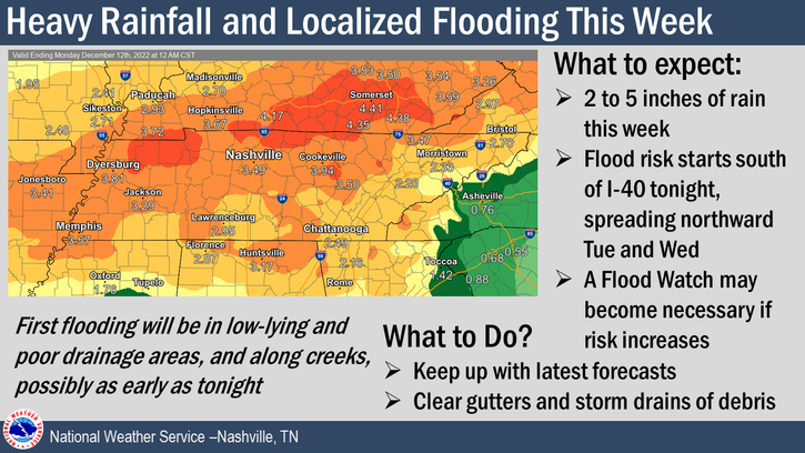
On and off rain for the week begins this morning, continuing through Tuesday and Wednesday – as shown by the HRRR model below. Heavier rainfall totals today will be south of I-40.
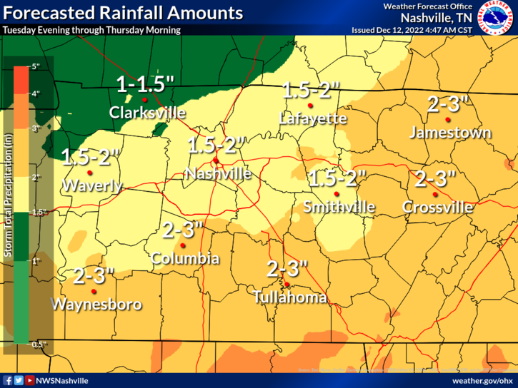
- Multiple rounds of heavy rain will continue throughout the week and into the weekend.
- Generally, rainfall totals will be from 2-4″, with locally higher amounts possible. In these locally higher amounts is where flash flooding risk will be elevated, along with the areas that usually flood. Unsure of where these higher rainfall totals may happen.
- NWS Nashville says a Flood Watch may be needed for areas that are believed to get higher rainfall totals – unsure if this would include our counties at this time.
- Some rumbles of thunder will be possible in the heavier downpours, but no severe weather is expected.
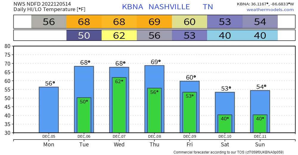
Temps mid-week will be above average, eventually making it back to around normal by the weekend.
One More Dry Day Before A Wet Week
Today will be chilly, with high temps only reaching the upper 40’s, but will at least be rain-free.
In between watching football and what not today, it’d be a great idea to go check your gutters and drains, chances are they likely have something obstructing them (leaves, twigs, etc.) and with all the rain coming up – it always helps when water flows where it is supposed to go.
A Day Or So Break In The Rainy Pattern

Today and likely Sunday are likely the only dry days in the next seven days, how nice….
Today won’t be the prettiest day, but at least it’ll be rain free. If you step outside now, it’ll be the “warmest” you’ll be all day as temps will gradually fall, ending up around freezing late tonight.
You must be logged in to post a comment.