Partly Sunny, Cold, Fluctuating Temps Later This Week

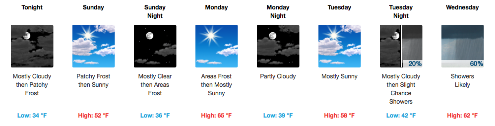
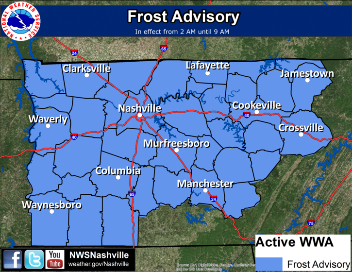
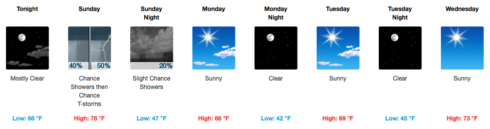
Rain Is Over, Cold Is Not!

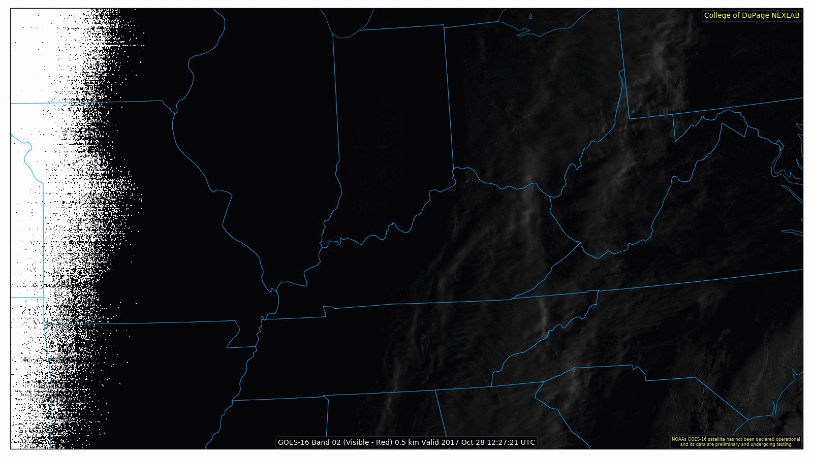
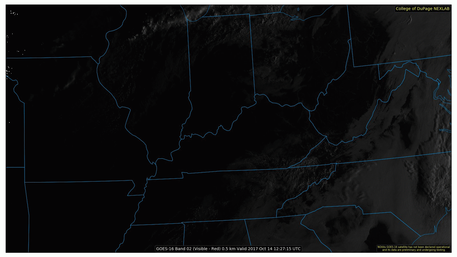
GOES 16 Morning Loop

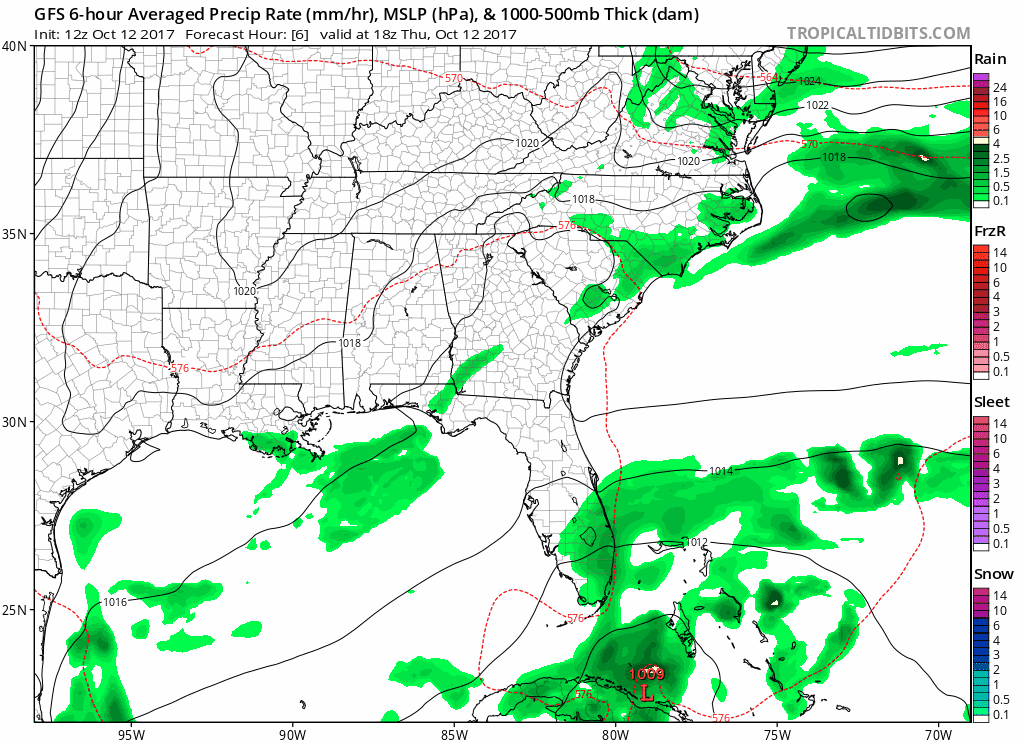
The rain from last night has pushed well east of us and now we are just plain cold. Temperatures are starting around the 40ºF this mid-morning and will only reach into the upper 40s this afternoon. A light northwest breeze will nonchalantly bring in cooler air throughout the day. Wind chills are expected to remain in the lower 40s, dropping below freezing into tomorrow morning. read more

Warmth Short-Lived, Rain Signals Big Cold This Weekend

Much Warmer Today and Friday, But Don’t Get Used To It

A surge of warm air is already underway late this morning as southerly flow returns to Middle Tennessee. The latest HRRR models this well, but notice the main “axis” of warmest temps are still off to our south and west. read more

Frost Advisory For Morning, Roller Coaster (Mainly Cooler) Temperatures Coming

Frost Advisory Until 9AM, Fall Pattern Continues Into Next Weekend

* TEMPERATURES…Lows will be in the mid to upper 30s across Middle
Tennessee.

* IMPACTS…Sensitive outdoor plants may be killed or damaged by
frost if not protected.

PRECAUTIONARY/PREPAREDNESS ACTIONS… read more

Great Today and Tomorrow, Rain Begins Late Sunday

A Few More Clouds Today Before Sunday Rain

An increase in moisture will occur today ahead of a long-awaited, potent cold front that is expected to arrive on Sunday. Highs in the upper 70s to low 80s are anticipated this afternoon thanks to an unimpeded south wind. read more

Nice Days Before Weekend Rain, A Look Into Long-Range Temperatures

Continuing the Great Fall Weather, Uncertainty About Weekend Rain

Middle to upper 70s for afternoon temperatures seem to be a good bet heading into the homestretch. A gradual increase in cloud cover will be noted Friday but especially Saturday ahead of the next weather maker. read more

Solid String of Sunny, Room Temperature Days Ahead

A Few Fair Weather Clouds Later Today, But No Complaints!

View from “The Gulch” Camera At 11:20AM – Click here for a LIVE view

No clouds in sight this morning over Downtown Nashville. A few high cirrus are on their way from Missouri for later this afternoon, though. read more

Warm and Muggy Today, A Precursor For Sunday Rain

Patchy Fog This AM, Muggy and Warm Afternoon

GOES 16 Sunrise Loop

Fog is visible from space this morning over Middle Tennessee, but it isn’t widespread. By 11AM, it should all be mixed out.

HRRR Model Dew Points Through Sunday 1AM

read more

Nice Friday Ahead, Warmer and A Few Storms This Weekend

NOTE: Barring a partly/mostly clear nighttime, fog could develop and be around for tomorrow’s morning commute.

GFS Model Loop through Sunday Morning

We will remain dry through Saturday as high pressure continues to hold in place through then. Flow will become southerly on Saturday, so expect temperatures about 10-12 degrees warmer than they are today (middle 80s). read more

Stormy Today, Great Looking Week and Weekend Ahead

Gloomy and Rain-Filled Tuesday

Regional Radar 11:30AM CDT

Rain has encompassed much of Middle Tennessee this morning and another heavier batch is moving in from the west for the lunch hour. Plus or minus a few more showers after this next rain swath, we will be largely done with measurable precipitation by late afternoon/evening. The HRRR is in good agreement with this scenario. read more

Hurricane Nate To Make Presence Felt In Middle Tennessee

Soggy Weekend and Start To the Work Week

Some fast moving showers have popped up over Middle Tennessee this morning, in addition to extra cloud cover. A gradual increase in rain coverage is expected today as moisture pumping in from the Gulf of Mexico and Hurricane Nate aid in shower development. Additionally, a frontal boundary will spark off a few storms after dark tonight. read more