Clouds Hanging Around Today, Waiting on Weekend Warm-Up

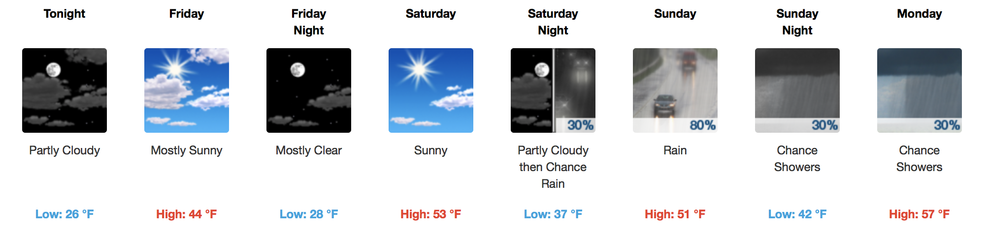
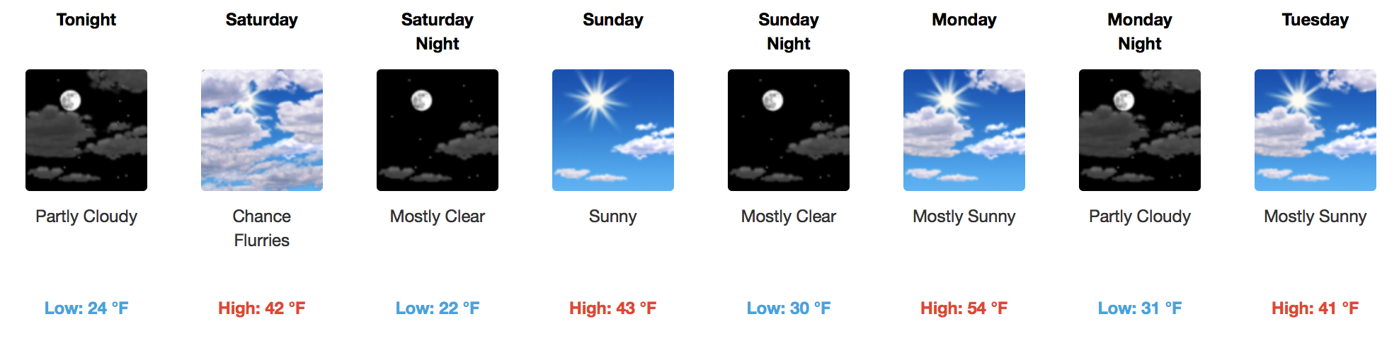
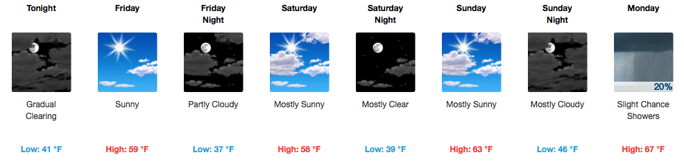
Cooler Through Friday, Warm Weekend

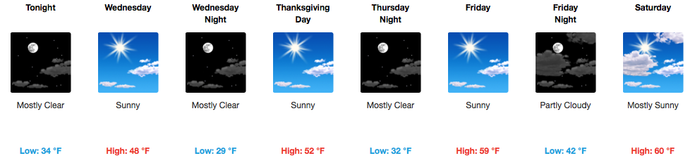
Clouds will have a difficult time breaking up today, but we may get a few peeks of sunshine in the late afternoon. Our area is behind a cold front, so colder temperatures are filtering in. 20s are expected overnight into tomorrow morning, and we’ll only rebound into the mid-40s Friday afternoon. read more

Raw, Cold Day! Sun Intermittently Before Weekend Rain

Dry Spell, Not Much Moisture To Work With

GFS Model Loop Through Sunday

Temperatures will fall after a high in the 50s on Wednesday back into the 40s on Thursday and Friday afternoons. Winds will pick up on Wednesday afternoon with the passage of a dry cold front, gusting to 25 mph. Expect variable cloudiness and a decent amount of sunshine. read more

Sunshine Returns Sunday, Cold Remains

Sunshine is Back, A Few Clippers This Week

Highs will reach into the 40s for Sunday and well into the middle 50s by Monday thanks to a southwest wind. Our next “weather maker” arrives Tuesday with a reinforcing shot of cold air and a few flurries possible. read more

Cloudy and Cold, Some More Sun Into the Weekend

Cold Continues, Not Much Moisture To Work With

Quiet and cold conditions are in control for today with snow and wintry precipitation well to our southeast. In fact, this forecast blog is being written from snow-stricken Mississippi, where areas down yonder have accumulated nearly 6″ of white, heavy powder. read more

Temperatures Plummet, Rain Ending. Sunny to Chance of Snow By Saturday.

Rain Exits By Lunchtime, Temperatures Already Falling

Radar Loop at 10:15AM

Rain is moving out and colder temperatures are rushing in! We hit 64ºF very early this morning, but ever since then, we’ve been slowly dropping into the 50s (now 54ºF at BNA). Expect this trend to continue for the rest of today as a deep, cold airmass dives southward over the next 24 hours. read more

Unseasonably Warm Leads To Unseasonably Cold Midweek

Beautiful Weekend Precedes Cooler Weather Next Week

Temperatures have already climbed into the lower 50s this morning and will continue to rise with additional sunshine. Today’s official high of 64ºF is several degrees above what was previously forecast, so take the opportunity to get outdoors…maybe to put up some decorations! read more

Rain Exits Today, Nice Weekend Ahead, Active Next Week

Cooler Air Works In

WPC Surface Analysis at 6AM

A northerly component to the light breeze will usher in cooler air behind the cold front.

24-Hour Temperature Trend

[av_textblock av_uid=’av-tufcg6′]
[cjtoolbox name=’Treg DONT DELETE’]
[/av_textblock] read more

Sunny and A Bit Windy Today, Showers Possible Thursday

Sunny, Gusty Winds Out of the South Today

Surface high pressure is moving east towards the Atlantic U.S. Coast this morning, allowing southerly flow to pump in warmer air. This afternoon, temperatures will rise into the middle 60s with winds gusting as high as 20 mph. read more

Cold Front Today, No Rain Until Next Week

Dry Cold Front On the Way

WPC Surface Analysis

No rain with this one! The atmosphere is quite dry this morning over Middle Tennessee. Expect partly cloudy skies into the early afternoon, then clouds quickly clearing by evening. Temperatures will fall into the middle-lower 50s by 6pm, from a high of 63ºF around 3pm. read more

Quiet Weather Pattern, Just Up and Down Temperatures Through Thanksgiving

Warmer Today, Much Colder Again Tomorrow. Roller Coaster Temps!

It is already 45ºF at the airport this morning, a good deal warmer than this time yesterday morning. Sunshine and a light south wind will bump our temperatures up nicely into the lower 60s this afternoon. read more