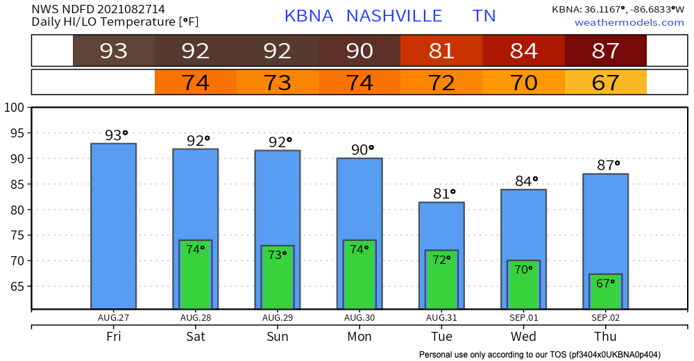
Woo you made it to Friday! Now let’s talk weather.
Friday for the most part is looking sunny. Temps in the low-mid 90’s coupled with dewpoints in the low 70’s will make it feel pretty hot and humid. Deodorant is our friend.

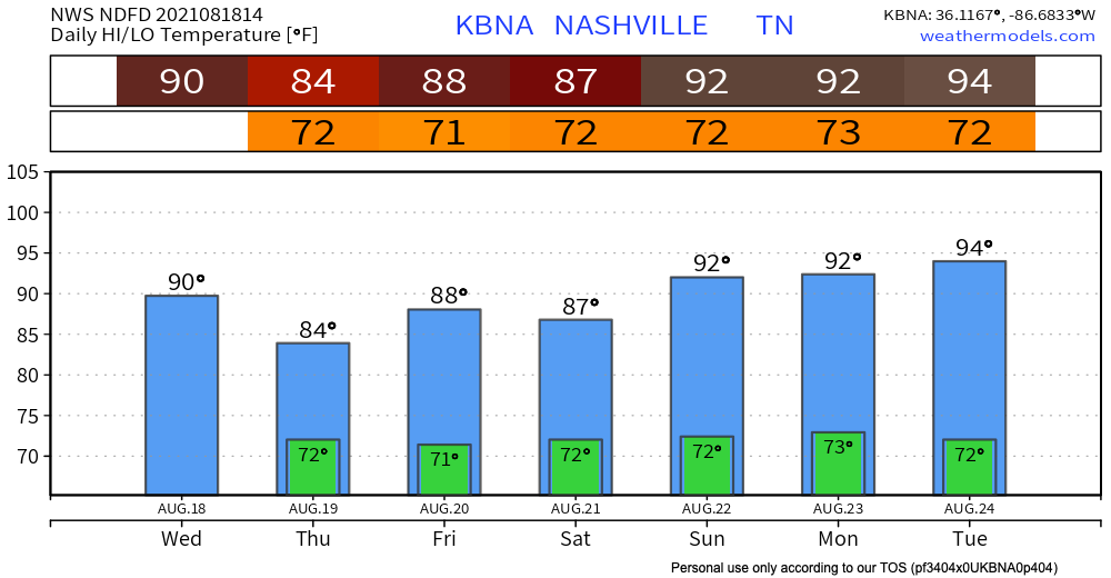
Woo you made it to Friday! Now let’s talk weather.
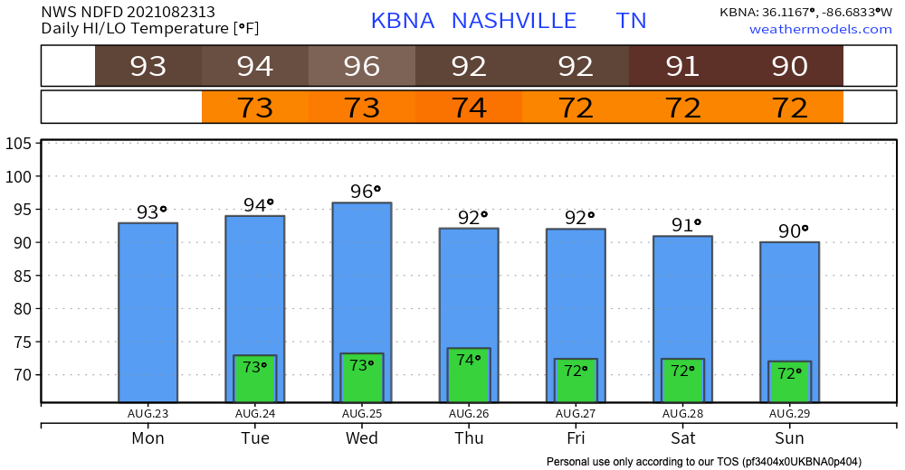
Friday for the most part is looking sunny. Temps in the low-mid 90’s coupled with dewpoints in the low 70’s will make it feel pretty hot and humid. Deodorant is our friend.
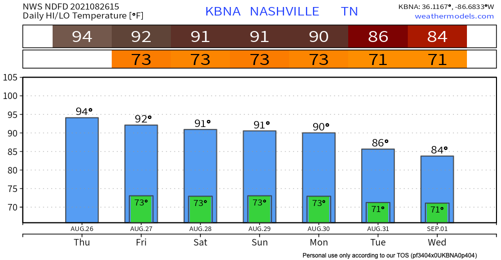
If you read yesterday’s blog then today will sound familiar. High’s in the low-mid 90’s and dewps in the low 70’s making it feel like 100 degF. Afternoon showers and thunderstorms roll in mid afternoon. No severe weather is expected out of these storm pockets. Always be prepared for lightning and possible high wind gusts.
Isolated storms pop into our area starting around 1pm. After 7pm the show seems to be over and any rain stays to our east, see HRRR below. Only threat in this bunch of storms is lightning.
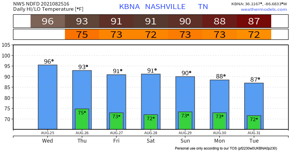
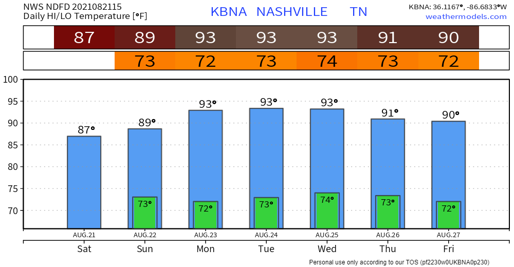
High temps in the mid-90s combined with dew points in the low 70s will make it feel like 101 this afternoon.
High pressure should keep skies clear and dry for the better part of this week. No rain in sight today.
It’s hot. Highs in the mid 90s, dewps up in the low 70s. Result: triple digit heat indices again… maybe higher than yesterday. Below is the heat index outlook for the next couple days. One word: Sweaty.
Today, a high pressure system overhead keeps us rain-free.

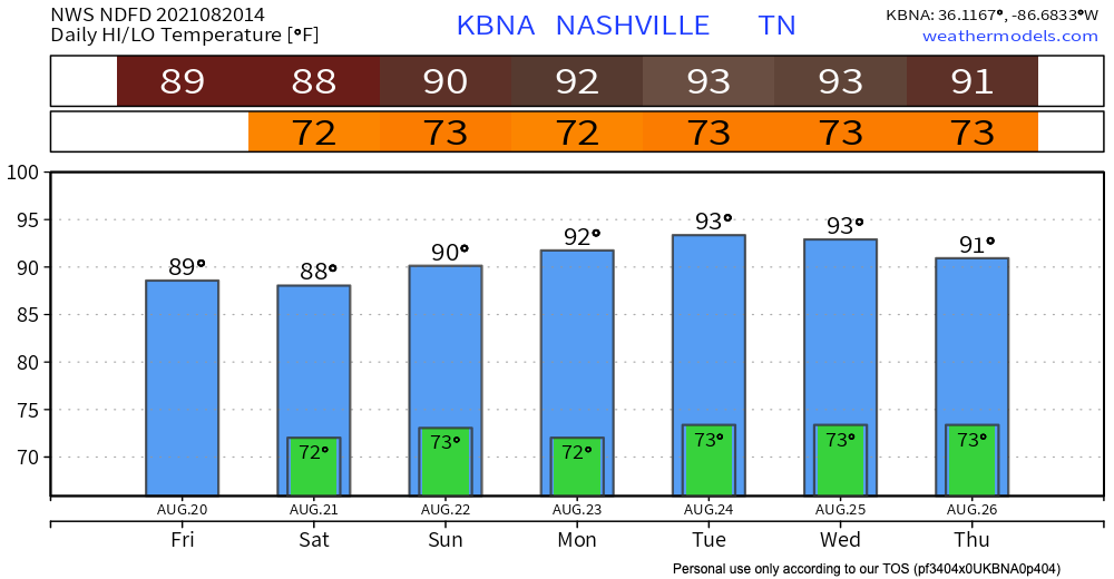
It will definitely feel like summer today, with mid 90s temps and dewpoints in the 70s. Here’s what the heat index looks like on the NWS Blend of Models. Pro tip: on the model, red means hot, white means really hot. Heat indices look to get right up near 100°.

The heavy rain is finally over for us and our western neighbors.
Today the HRRR shows some showers to our south in the late morning. If anything does pop up in your neighborhood, it will be brief and of little consequence.
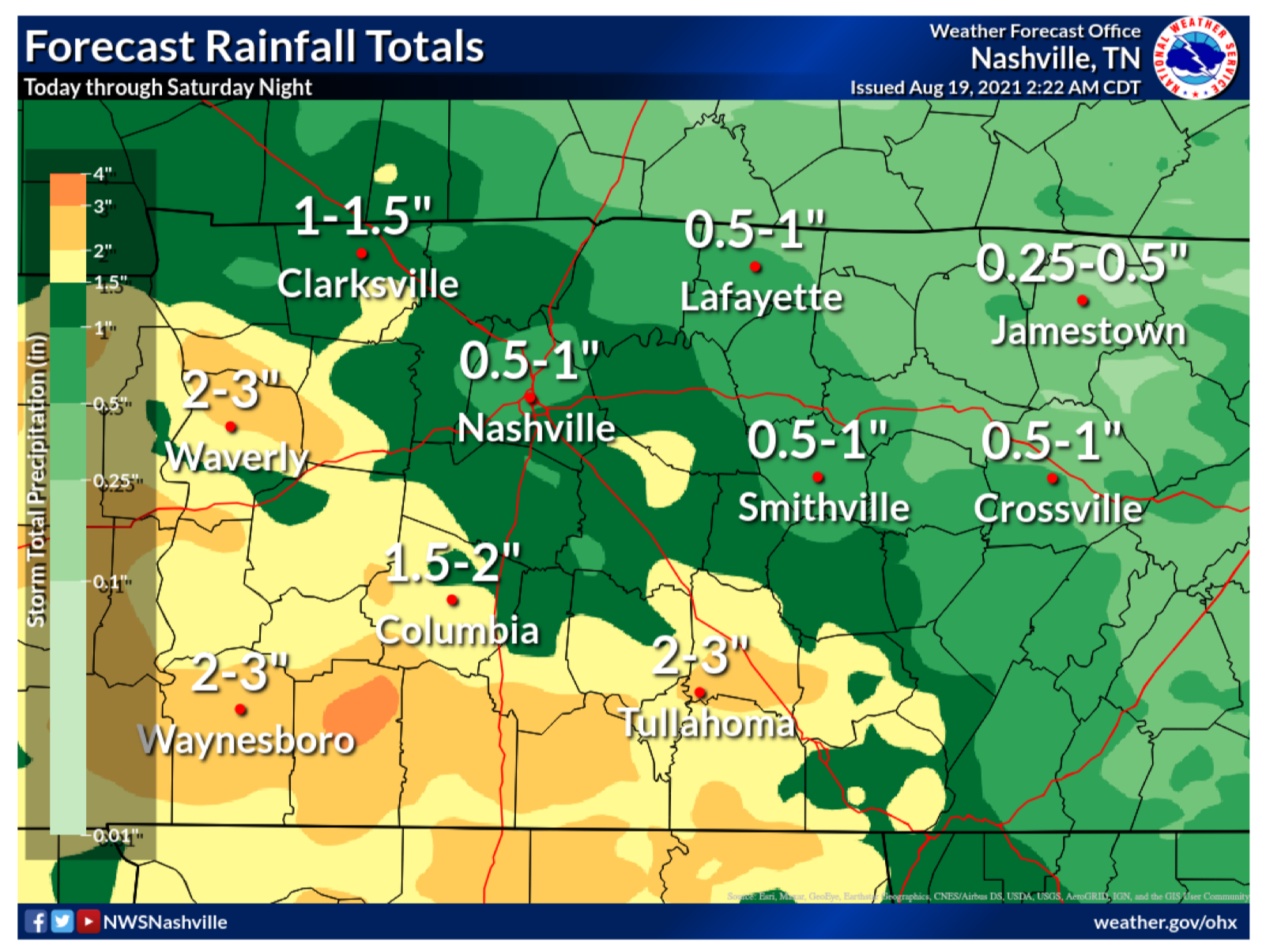
Editor’s Note: Flash Floods. We’ve been through them. They’re a painful reminder of how quickly weather can take away what has taken years to make…homes, businesses and beautiful landscapes. Today, our friends just to our west are dealing with catastrophic flooding with well over 11 inches of rain, maybe much more, falling just this morning. The beautiful Piney River is roaring at 31.8 ft at the time of this writing, a staggering 7.8 ft above MAJOR flood stage. If you have friends in Humphreys, Hickman, Dickson or Houston Counties, please check on them by phone/text if you’re able. They’re going to need much to rebuild what water has taken away today.
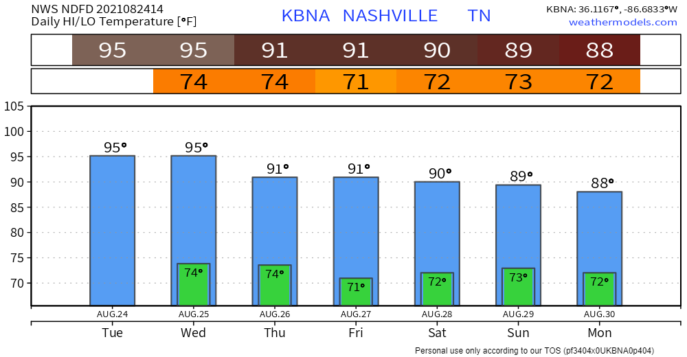
Scattered storms from last night have lingered around and are still in our area this morning. HRRR has these storms hanging around most of the day. No severe weather is expected with these. Main concern is lightning and gusty winds.
Storms don’t reach our area again until 1-2pm. These won’t be as widespread as yesterday. Only threats with this batch is lightning and wind gusts. No severe weather is expected. Scattered storms continue into early Friday morning, see HRRR below.
The Storm Prediction Center believes there’s a 5% chance you will see damaging straight-line wind within 25 miles of you today and tonight. While the threat is low, it is not zero. Two of our communities have seen the affects of microbursts recently, Oak Hill and Nolensville. Will we see another one today? We don’t know. But, the chance is there and worth noting, especially if your plans include being outdoors.
You must be logged in to post a comment.