
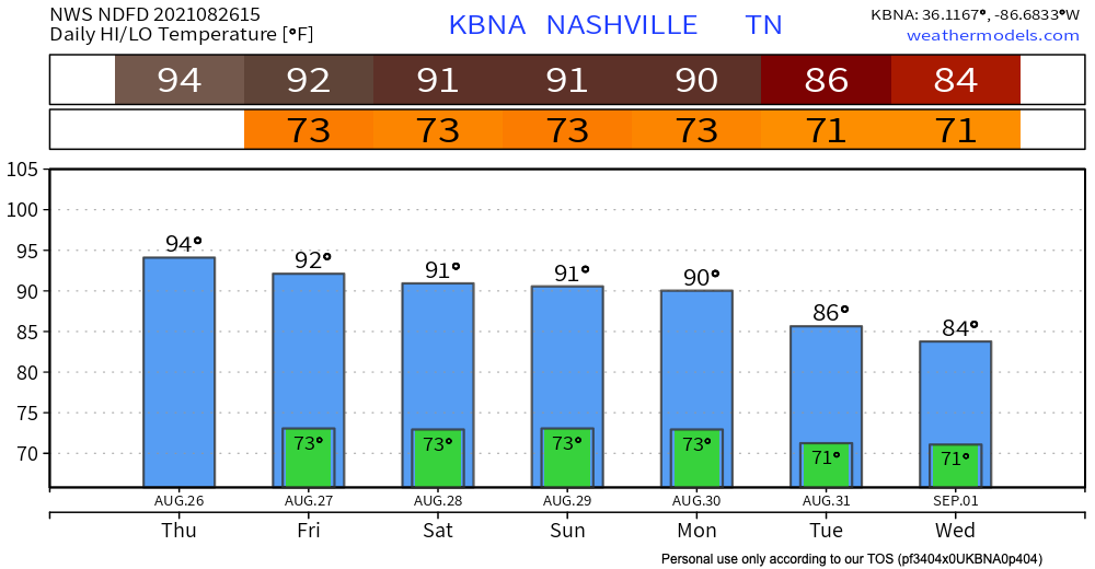
If you read yesterday’s blog then today will sound familiar. High’s in the low-mid 90’s and dewps in the low 70’s making it feel like 100 degF. Afternoon showers and thunderstorms roll in mid afternoon. No severe weather is expected out of these storm pockets. Always be prepared for lightning and possible high wind gusts.
HRRR model has Friday afternoon looking a little cooler but with similar afternoon storms. The euro shows Saturday and Sunday looking the same as Friday. All these weekend afternoon storms are more sporadic and roll in around mid afternoon and disperse by 10pm. No major threats.
Rain Next Week and Why
Expect rain to follow us into next week. Tropical Depression 9 advisory 1 was just released. TD 9 is expected to hit landfall at Louisiana Sunday morning and then basically travel up the Mississippi river into TN. Tuesday is going to be a wet one for us as this system will have reached us by that morning.

Stay tuned for updates more on how this will affect our area and ETAs.
Categories: Forecast Blogs (Legacy)
You must be logged in to post a comment.