Sleet, Freezing Rain, or Just Rain Tonight/Overnight?

There is no “one size fits all” forecast for Middle Tennessee tonight.

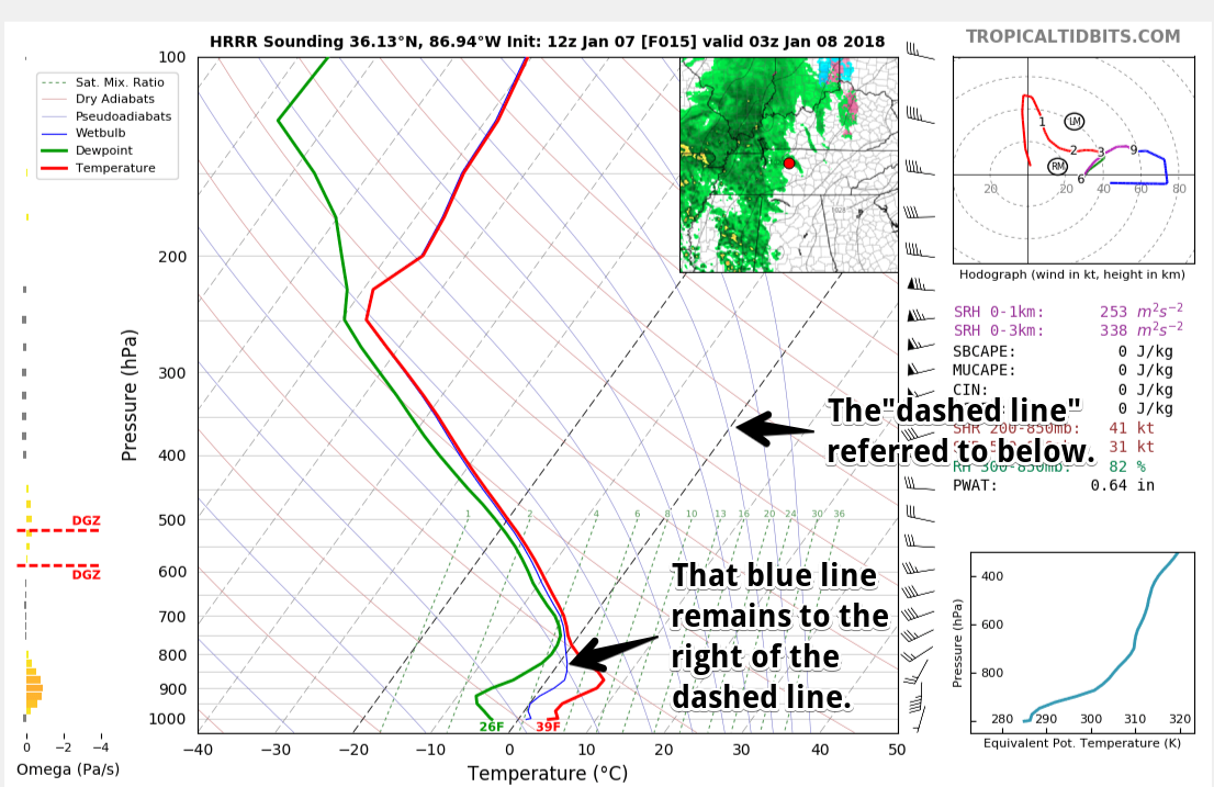
1.  For Davidson and Williamson Counties, the NWS-Nashville forecast from 9 PM to midnight includes a chance we will get all rain, a chance it’ll be a sleet and rain mix, or a chance of all sleet; however, the most likely result will be rain. Freezing rain is not mentioned because temps are expected in the upper 30°s. There is no mention of snow. read more

Brisk Day/Night, Then Wintry Mix and Warmer Temps

Below 32ºF Today, Above 32ºF Tomorrow…Wintry Precip. Possible

Cloud cover will be intermittent today, with cold temperatures being the main story. Most places around Davidson/Williamson Counties will struggle to reach the upper 20s!

One last, brisk night is in store with forecasted lows in the teens, followed by a “warm up” Sunday and beyond. There’s just one speed bump in the way… read more

Rain..Freezing Rain..Sleet Sunday Night? Probably Just Rain, But Stay Tuned!

It’s Cold!

Temps will not reach above freezing until Sunday.

https://giphy.com/gifs/cold-freezing-101-dalmatians-NrwULs858gcms

Frozen Precip Chances Sunday Night

We’re going to warm above freezing right around the time precipitation arrives. read more

Chilly Chilly Temps Continue. Somewhat “Warmer” Next Week

It’s Cold!

Frigid temps continue today and tomorrow. Temps will not reach to above freezing until Sunday. Stay bundled up over the next 48 hours folks.

https://giphy.com/gifs/cold-freezing-101-dalmatians-NrwULs858gcms read more

Still Cold, Slight “Warm-Up” Coming

Frigid Temps Return For Now

Yesterday, we had the pleasure of seeing some temps above freezing for a little while. Unfortunately, temps have fallen back below freezing and look to stay there through Saturday.

https://giphy.com/gifs/snl-3oEjHKj26YqQmAFgqY read more

“Heat Wave” Today Followed By More Brrrr

Temps Are The Story Today

Ok. Let’s get above freezing today. What do you say?

Our low of 16° this morning should warm to 34° at BNA today, breaking our streak of temps below freezing…but only for a few hours. Remember, our temp has been below 32° since Saturday evening. But, I don’t think I have to tell you that. read more

More Brutal Cold In Near-Term, Warming Trend Next Week?

Wind Chill Advisory Expires at Noon

GOES 16 Loop from this morning

If you were out the door early, WOW was it cold. Some Middle Tennessee locations set local low temperature records, like Crossville at 1ºF. Sunshine should help our area rebound into the middle 20s today, and winds will be dying down. Thus, the Wind Chill Advisory ends at noon. read more

2° Overnight (not a typo); Wind Chill Advisory in Effect

The overnight low is 2°.

2° is expected shortly before dawn. Before then, 10° at 9 PM, 7° at midnight, 6° at 3 AM.

Note that’s the official forecast temp; locations around Davidson and Williamson Counties are often a few degrees colder. read more

Wind Chill Advisory. Stupid Cold.

Temps in Middle Tennessee overnight ranged from 4º in Dickson to 14º in Gallatin. In a few places a few flurries broke out, but nothing of consequence.

As I write this morning, officially at BNA it’s 7º, and the wind chill is -7º. Minus seven. Many backyards in Nashville and Will Co are a few degrees colder. read more

Ring in the New Year with Two Wind Chill Advisories

Two Wind Chill Advisories are in effect.

The first is effective begins at 10 PM and ends at 9 AM Monday morning. A second Wind Chill Advisory goes into effect Monday night at midnight, running until noon Tuesday.No snow, just cold the rest of the week. Below freezing at least through Wednesday, maybe longer. Winds turn south Wednesday, so we may make the mid-30º. If we do, it will break a below-freezing streak that started Saturday night. If not, the streak should end Saturday when we should poke above freezing (but only briefly) in the afternoon. 7 consecutive days completely below freezing would be two days shy of the record of 9 set in 1876 and 1899. read more