Snow, Sleet, or Rain Wednesday Night into Thursday? When Will All This Ice Melt?

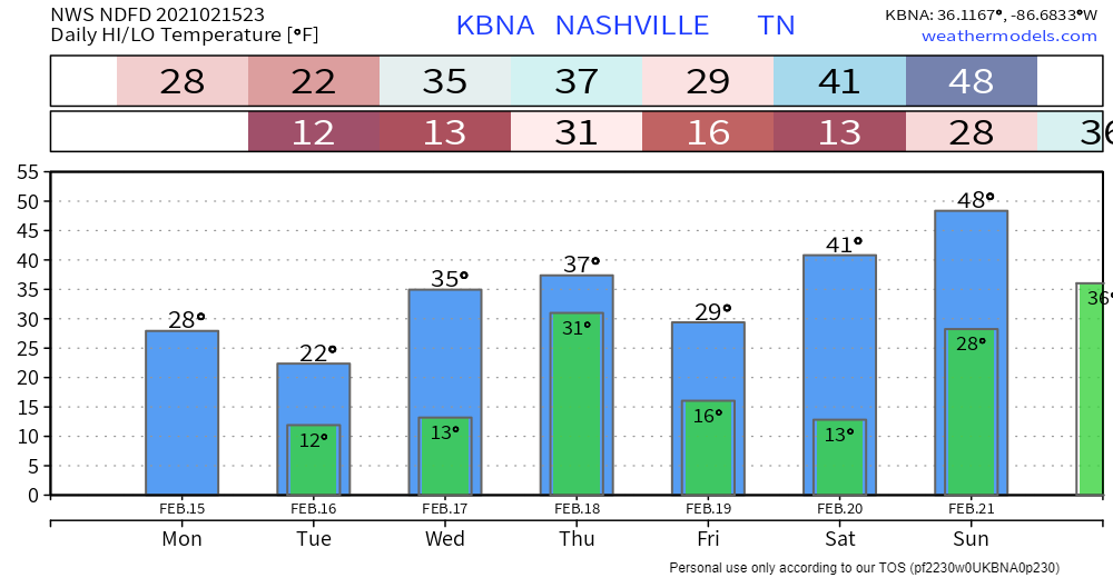
First a personal note. I put on a guy on blast on Twitter this afternoon. I shouldn’t have. I got frustrated because I thought his criticism was unfair, and for a minute I thought I was in court. Those who disagree with me or don’t like the way we do things nevertheless deserve my respect. Dragging anyone’s tweet out in front of our audience out of anger and revenge in order to shame them to try and win an argument is not cool. What I did was, and is, wrong. Twitter feuds drive a wedge between us, no minds change, we all just end up angry. I apologized to him (to his credit, he was the bigger man and reached out to me first). The truth is my pride in what we built made me a jerk. I should always be kind. I’ve been given grace, and I did not return it. David. read more

Winter Storm Warning - Charge Your Mobile Devices!

Significant Ice Accumulation AND Snow

A Winter Storm Warning is in effect for Davidson and Williamson Counties until 6 AM CST Tuesday morning.

This afternoon:

Sleet and freezing rain will continue through the afternoon, with the snow line inching our way as well. Snow is currently in west TN as of noon. read more

The Trend Toward More Ice, Less Snow.

Roads, steps, decks, and sidewalks coated with black ice this morning and this afternoon are dealing with a heavy coat of sleet tonight. Travel is dangerous. Do not try it. 4WD may provide traction, but it cannot assist your stop. read more

Winter Weather Advisory Until Noon for Slick Roads. Winter Storm Warning Begins Tonight for Ice and Snow into Monday

Travel is hazardous this morning. Our replies are filling up with “black ice” and “skating rink” stories. And that was just due to overnight freezing fog and freezing drizzle.

Happy Valentine’s Day everybody! read more

Winter Storm Watch. Ice, Then Snow Incoming Sunday & Monday.

“This is an evolving forecast that will likely change over the next 24-36 hours.” –NWS-Nashville.

Saturday night – Sunday morning, there may still be lingering slick spots on bridges and overpasses. Drizzle on windshields means black ice on roads. read more

“A significant winter storm Sun-Mon is becoming likely…” -@NWSNashville

Until 10 AM this morning (Saturday) a Winter Weather Advisory warns of freezing fog, freezing drizzle, and a few patches of light freezing rain laying down “ice accumulations of a light glaze.” read more

Watching Several Winter Weather Events Over the Next 7 Days

Beware of Freezing Fog/Drizzle This Morning

Bridges, overpasses, and elevated surfaces may be slick.

There is a lot of elevation variation throughout Williamson and Davidson counties, so it’s hard to say if your street specifically will have black ice. The safe thing is to assume that your street has slick spots. Then maybe you will be pleasantly surprised. read more

Black Ice Concerns Tonight & Overnight, with 3 more Wintry-Precip-Possible Systems on our Horizon

Image

Rain ended after lunch. Instead of dry weather and a stiff wind, we got a steady drizzle for several hours.

Drizzle wet the streets.

Temps are dropping and should reach freezing everywhere in Davidson and Williamson Counties tonight. Black ice will form in spots, regardless of elevation. Many places will drop to 30°, some may get colder. read more

Some Ice Today, Active Winter Weather Pattern To Continue

Let’s Talk About The Possible Ice Event Tonight/Thursday

Overnight, the National Weather Service issued a Winter Weather Advisory for both counties for the possibility of freezing rain. This will go into effect at 6pm tonight through 6 pm Thursday.