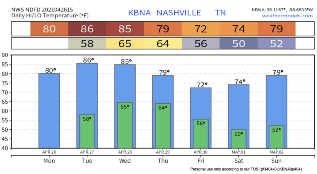
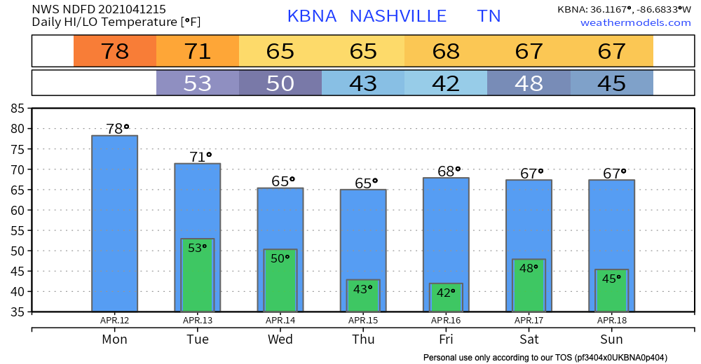
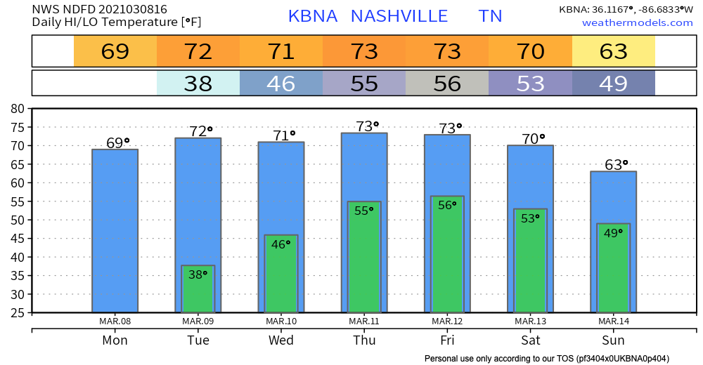
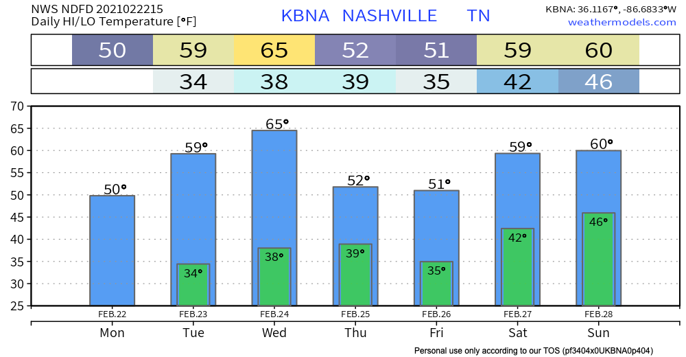
Thursday Night Rainout?

Kinda Hot.

Check those temperatures out!

nervous drake and josh GIF

Editor’s Note: gross.
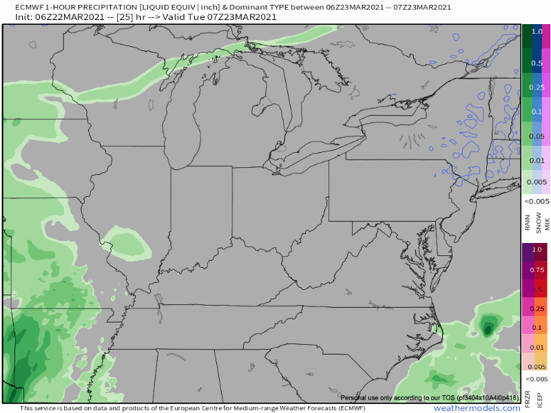
Next Rain Event

The Euro model shows a few showers around Wednesday afternoon, but that looks light and inconsequential.

A steadier, heavier rain is expected Thursday afternoon and/or evening. Exact timing remains unresolved, but this looks most likely to be a Thursday night thing.

Rainfall estimates look to total close to an inch. Thursday night stuff may be rained out. Cancel no plans for now. Rain could delay into the overnight hours Thursday night.

Clearing Friday. We dry up for the weekend and continue warming into the upper 70s by Sunday!

A Couple of Stray Showers Today, Remaining Dry Through Tuesday

Maybe You’ll See A Stray Shower, Maybe You Won’t

Skies will remain rather cloudy today but in terms of rain, however, very on and off pattern for the majority of the afternoon into the night.

You may see a stray shower in your backyard, you may not. We’re mainly eyeing a couple of passing sprinkles.

Temperatures will hang around the low to mid 60s with overnight lows in the mid 40s.

Sunday

We’ll see another day kind of like today but the chance for an afternoon shower cannot be ruled out.

Temperatures a bit warmer in the upper 60s.

Drying Out Monday and Tuesday

Sunshine returns Monday and Tuesday with temperatures in the lower-to-mid 70s. We’ll see dry conditions last through the early week before another cold front moves through Tuesday night bringing another small chance for some showers to the area.

This cold front will bring high temperatures Wednesday to be rather cooler below average. Highs on Wednesday will linger in the upper 50s.

This may be some frozen precipitation as temperatures will drop overnight near freezing.

Ron Burgundy What GIF

We’ll continue to warm back up through the end of the work week into the weekend.

Until then, Happy Saturday. And as always, check back for updates to the forecast, and be sure to follow @NashSevereWx on Twitter!

Few Light Showers, Otherwise Quiet Week Ahead.

It’s peak severe weather season right now and we are super quiet. Medium and long range model data suggests (but doesn’t promise) we’ll stay quiet until end of April/early May.

Today:

sun GIF

Clouds roll in tonight. Expect a few rain showers around Tuesday. They will be light and scattered. Not all of us will see rain. Those who do, no big deal.

The NAM3km model brings in off and on, no-rainout, showers mid morning through late afternoon Tuesday.

HRRR model, same:

Clouds remain through Wednesday with scattered, off and on, light showers through Wednesday around lunch. No rainouts.

A cold front will drop into the area Wednesday night, dropping high temps Thursday and Friday.

Weekend Outlook

On-and-off showers are possible Saturday, but not a big deal. There’s no clear signal in the weather models, though. More on this in the later days.

Next Rain Event Late Wednesday - Thursday.

Happy Easter!

Sunshine and a warmup through the mid-week.

Our next chance of showers and thunderstorms arrives Wednesday night and continues Thursday.

The approaching storm system presents some severe risk for Arkansas and West Tennessee. Severe is unlikely for us. The system appears to weaken a bit and become just a rain event with low-powered thunderstorms by the time it gets here. ETA most likely very late Wednesday into Thursday morning. Timing remains iffy, though, because hi-res models are not yet in range.

Below the Euro illustrates the rain sweeping in from the west.

WPC has us down for about 1″ total. That won’t be enough for flooding.

A cold front is expected to move through Thursday night bringing “cooler” temperatures with it. (I put “cooler” in quotations because temperatures will only be dropping a few degrees… you probably won’t even notice a difference.)

Another system moves through late work week into the weekend. Models are all over the place. This prevents us from drawing conclusions.

Clearing Skies Today, Scattered Showers and Thunderstorms This Weekend, More Rain Next Week.

Quiet Friday

Check out today’s sunrise over the hills surrounding Grassland in Williamson county.

Image

After last night’s severe weather, we dry out for most of today followed by decreasing clouds throughout the morning. We’ll be topping out near the upper 60s for our high temperature and the lower 50s for our low overnight tonight.

Enjoy today’s weather while it lasts! Our next round of showers and thunderstorms lingers tomorrow morning and night.

Stormy Saturday

SPC Categorical Outlook:

A warm front is expected to move north over the area late tonight into early tomorrow morning bringing a round of scattered showers and stronger thunderstorms. We’ll see most of the activity kick up closer to 6 AM tomorrow and carrying through to early afternoon. The main threats Saturday morning are looking to be heavy downpours, frequent lightning, and damaging hail.

3km NAM for Saturday Morning/Afternoon

We then get a break in activity in the afternoon until a cold front pushes southeast late Saturday night/early Sunday morning, bringing a more organized line of showers and thunderstorms.

Main threats associated with this line are damaging winds, large hail, local flooding, and if any of these get the ability to rotate, the possibility of an isolated tornado cannot be ruled out.

3km NAM Overnight Sunday – Sunday Morning

Probabilities for Saturday’s event do not look as high as what we saw yesterday.

Make sure to stay weather aware during this event tomorrow. Have a way to receive weather warnings and always make sure to indicate your safe spot if storms do become severe.

Looking Towards Next Week

Another break from thunderstorm activity is indicated for Monday and Tuesday!

Celebrate So Excited GIF by Hey Violet

Around mid-week we’ll see our next chance for showers and storms arrive as another frontal boundary pushes through the region. Temperatures cool slightly next Thursday with projected highs only in the 50s.

Rain Tuesday, Rain & Storms Thursday.

Rain is pretty likely Tuesday. Notice how it scatters and breaks up as it gets into Middle Tennessee on the Euro model (but we still get rained on):

The HRRR model doesn’t think it’ll break up. It thinks a heavier band of rain will cross through after lunch.

After that, off and on showers, with even a few downpours, into the evening. Totals on average 0.14″ total. Can’t totally rule out lightning in the afternoon or early evening, but this is mostly a rain event.

Winds will be gusty, up to 30-35 MPH.

Some light showers may fly by Wednesday but most of the day should be uneventful.

Expect rain Thursday. Maybe even strong storms.

A very healthy negatively tilting upper trough swings in from Texas on Thursday and intensifies a surface low that tracks through the MO boot heel. Even if the GFS verifies over the Euro, we could see at least some strong storms Thursday afternoon and evening.

NWS Forecaster’s Discussion 03/22/2021

Although we are a few days out from this, we can still expect strong thunderstorms. The biggest concern with this system Thursday so far will be straight line winds. As of today, the official convective outlook remains to our south but borders the southern edge of west Tennessee. There, stronger severe storm ingredients should be in place.

The timing is uncertain Thursday but it appears the day will wash out. The Euro shows heavy showers and strong thunderstorms as well as gusty winds.

We could squeeze an inch or more out Thursday. That’ll add to totals for Tuesday through Thursday night:

Weekend Outlook

A third system may be in store for us this weekend, but models are all over the place.

Sun Sticks Around Through Midweek When Rain Chances Return

A Quiet Start to the Week

Enjoy the sunshine while it lasts…

Long Weekend Sun GIF by Hollyoaks

High pressure remains in store for us through most of the work week and spring-like temperatures will continue for Nashville sitting at or above 70 degrees for most of the week!

Rain Chance Friday through Monday

The high pressure system sitting over us this week will eventually shift eastward into the Atlantic allowing a frontal boundary to ease into Middle Tennessee by Friday into Saturday.

Here’s what we’re looking like for Thursday afternoon into early Friday morning from the EURO. You can clearly define this boundary moving in from the northwest. We’ll se if it stays near the Kentucky border, or if it comes closer to us.

Some spotty showers expected late Thursday night into Friday afternoon. Timing of showers will become more clear as we get closer.

The heaviest rain looks to move through Saturday morning as this boundary drops across Middle Tennessee and continually slides south of us, but that will likely change in future model runs.

Wet weather looks to continue into early next week as a more pronounced system looks to come through.

Although that is past our 7-day outlook, we will monitor this within the upcoming days.

But for now…

Get out and enjoy the sunshine and warm air while it lasts! Clouds swing in Thursday night and we won’t see much sun for a few days.

Dog Sunbathing GIF by MOODMAN

As always, check back for updates to the forecast, and be sure to follow @NashSevereWx on Twitter!

Dry Times Ahead, Rain Iffy Tuesday Night

Nearly 4-5 inches of rainfall fell from last Friday to this morning in Nashville. Bit less in Will Co.

All rain today will be well south of us:

Rivers and creeks will take time to drain. Levels will slowly go down.

Another system will pass to our south Tuesday night into Wednesday morning. We may see light rain from it. The Euro model thinks so:

The HRRR model thinks we’ll stay dry:

The 0.12″ we expect over the next 7 days will come Tuesday night – Wednesday morning, but if the HRRR is correct we won’t see anything.

Dry weather ahead. High pressure builds in by Wednesday with another weak frontal boundary late Thursday, and even stronger high pressure into the weekend. This will keep precipitation chances very low towards the end of this week.

Temperatures stick around the upper 50s Friday through Sunday!

Mr Bean Beach GIF by Working Title

As always, check back for updates to the forecast, and be sure to follow @NashSevereWx on Twitter!

Storms on the Horizon Today through Monday Morning, Some Could be Strong or Severe.

Storms on the Horizon this Afternoon

Heavy localized rainfall and thunderstorms remain for the majority of the afternoon into tonight. The producer for this lineup is caused by a developing warm front moving northward over the area.

Mostly spotty showers and passing light rain will prevail from now until the late afternoon. The heaviest of rain does not appear to move over Nashville until around 8 PM tonight.

These heavier showers are developing along a frontal boundary, so it will come and go quickly overnight. Rainfall estimates through tonight are looking to be close to a half an inch total.

We get a break from the rain after the showers and thunderstorms lift north this evening until more showers and thunderstorms move in from the west tomorrow afternoon.

Trailing this warm front is a cold front that will drop into the mid-state but Sunday. Rain showers continue throughout tomorrow, but we’re expecting heavier rainfall tomorrow night into Monday morning.

Main threats: Damaging winds and possible hail.

SPC Wind Outlook for Sunday shows a 5% chance of damaging wind.

Sunday/Sunday night will be the biggest threat for flooding potential since the bulk of the rainfall is expected.

A Flood Watch is in effect for Davidson and Williamson County from 6 AM Sunday to 6 AM Monday.

Late Sunday afternoon into the evening is when we’ll see a line of heavier showers move over the area.

6hr Euro Rainfall Estimate

The main concerns are strong, gust winds, heavy rainfall, small hail and a possible isolated tornado.

Rainfall Estimates

This weekend is a soaker with Nashville looking to reach nearly 3 inches of rain.

Luckily, we dry up Monday and Tuesday morning with another chance of showers late Tuesday night into Wednesday.

Until then, Happy Saturday!

Transitioning from Snowy Szn to Rainy & Stormy Szn

Here Comes the Sun

The surface front that brought some showers early this morning is making its final eastward exit out of the Plateau.

Clearing skies today will stick around with us for a good portion of the work week with mild temperatures in the 50s and 60s.

Our warmest day this week: Wednesday.

GIF by Owain Wyn Evans

Slight Chance of Rain on Wednesday Night

But it probably won’t happen. A weak surface front will drop into the area Wednesday night but no one really thinks it’ll squeeze out showers.

Weekend Soaker

It’s looking to be a pretty wet weekend. The bulk of precipitation makes its way in on Friday as a warm front moves over the region, bringing widespread showers to the area for a majority of Friday and Saturday.

Timing is unclear right now. Best guess right now is rain most of the day Friday.

Both the Euro and GFS models agree on rain on Friday. The GFS stops the rain Saturday, but the Euro keeps us raining through Saturday.

Heavier rainfall is expected Sunday into Monday as another warm front sets itself up over the area.

Editor’s Note: We’re approaching the one year 3/3/20 tornado anniversary. Models show that week we will transition to more of a stormy pattern than a wintry pattern. Meaning, we are more likely to have thunderstorms in March than snow, so the change from snow szn to storm szn is underway. Take a moment to think about your tornado preparedness.

Within the next 7 days, rainfall totals for Nashville are looking to be just shy of 2.5 inches. Most of that should fall Friday through next Monday.

We’ll have more on this as the time gets closer.