Dry for Now, Active Weather for the Next Week

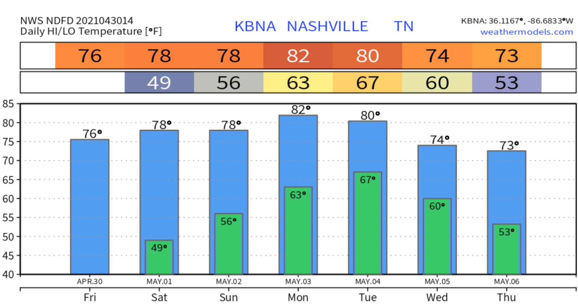
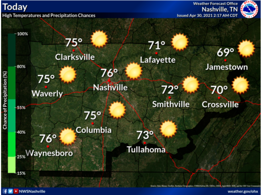
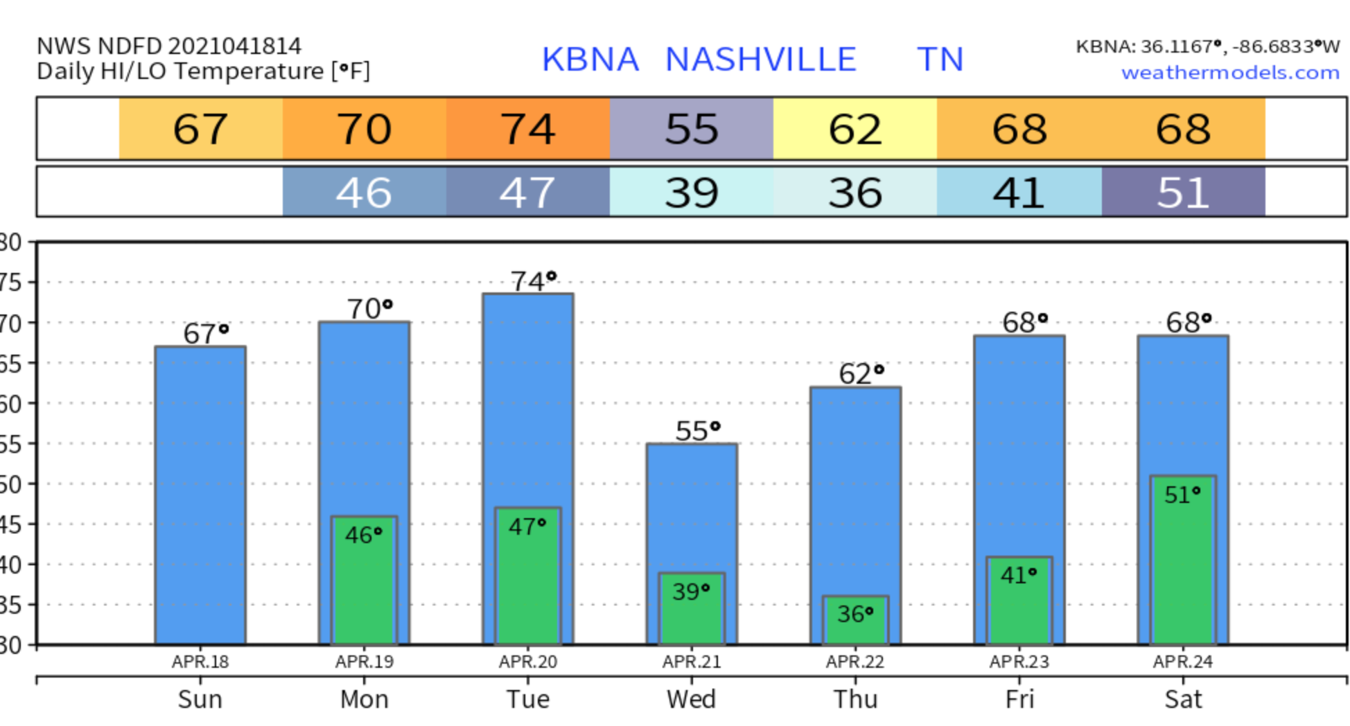
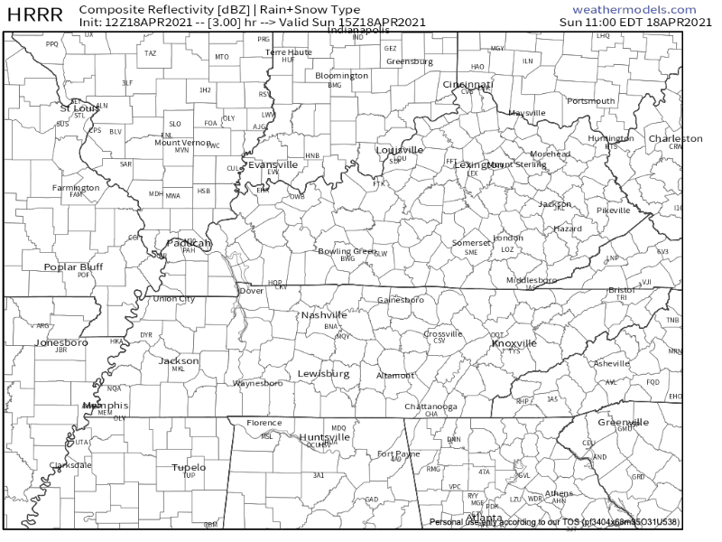
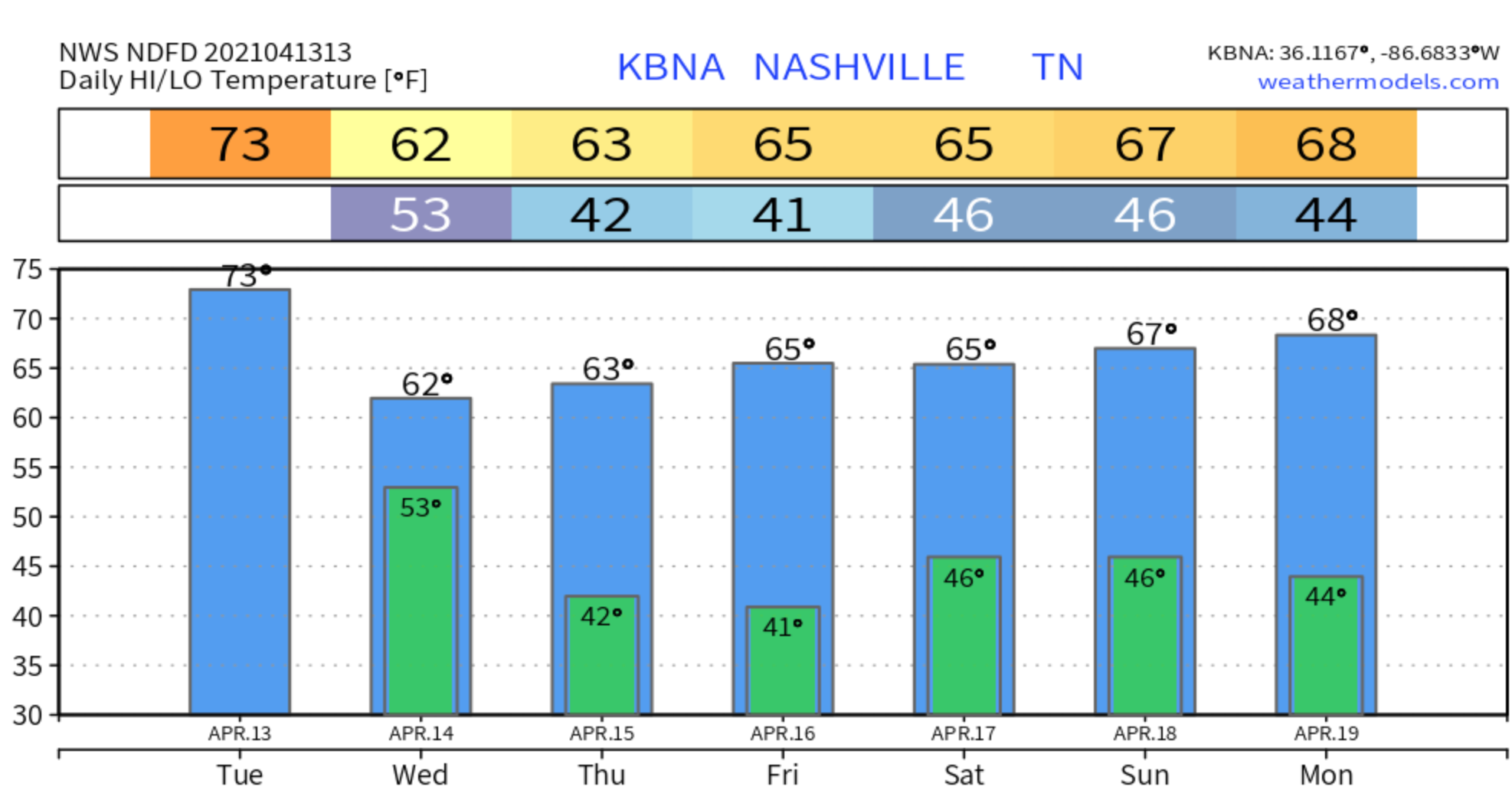
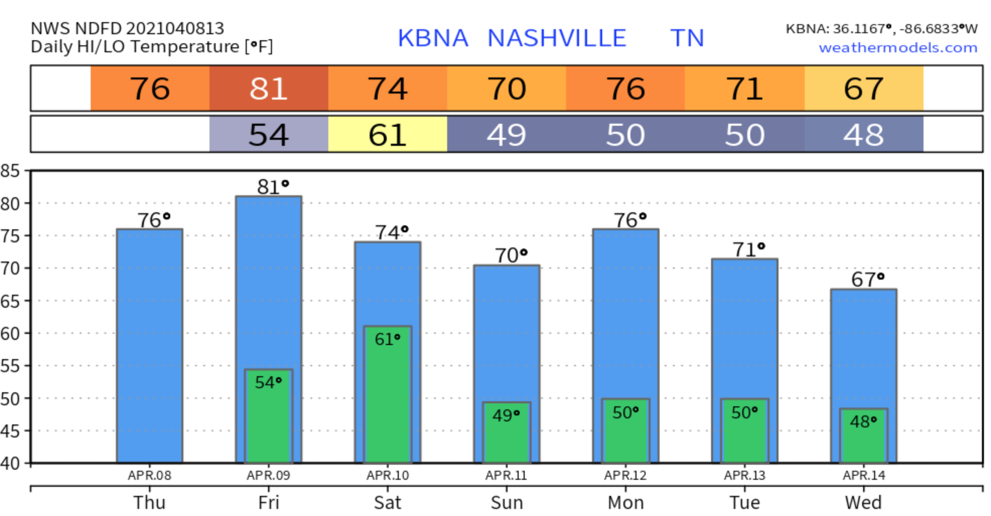
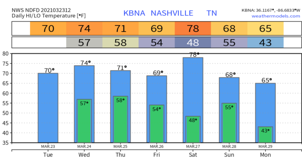
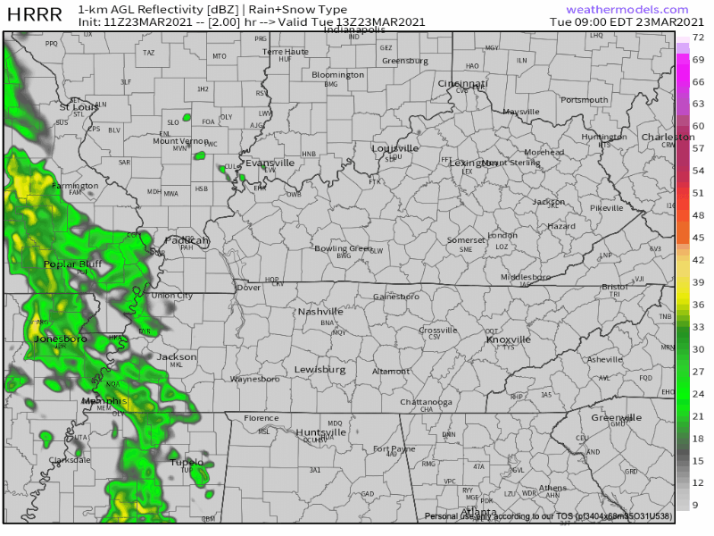
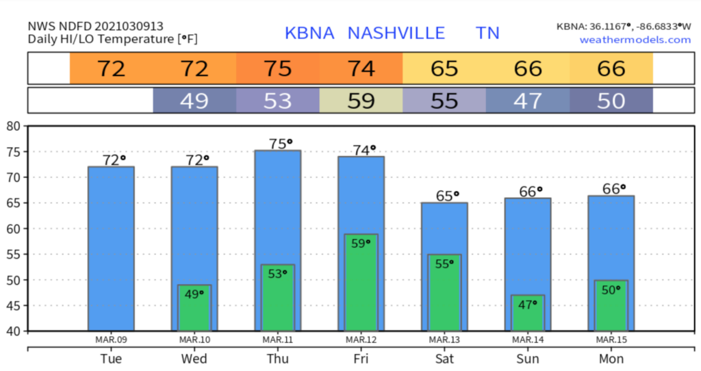
A nice and dry Friday in store to end the work week as high pressure builds in.

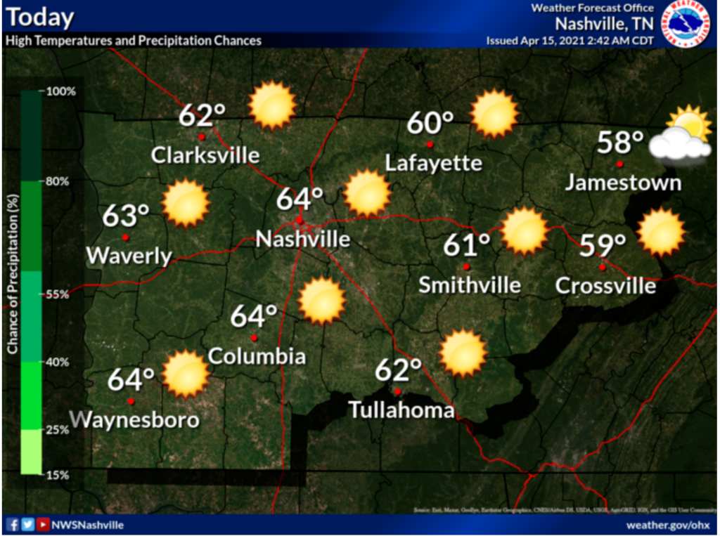
The cold front that passed through yesterday will make our temperatures a bit cooler today.

Same story in the forecast for Saturday. Sunny and dry conditions throughout the day, but temps will warm back up closer to the 80’s.

Active weather will return Sunday brining us decent amounts of rainfall and possibly some thunderstorms.

Primary timing for rain is looking to be after 2pm and continue the rest of the day and into the overnight hours.

Timing for any thunderstorms we may see is expected to be in the later evening hours after 8pm.

Into Next Week…

These showers and storms will continue into next week.

Monday looks to be an all day rain event with thunderstorms in the mix pretty much all day as well. Winds will be fairly high at 10-15 mph gusting 20 mph.

Tuesday showers and thunderstorms are expected once again and mainly all day.

More rain for Wednesday, but chances finally begin to decrease into Wednesday night.

Forecasted rainfall totals have a pretty significant amount of rain expected to be accumulated over the next several days. (Sunday-Wednesday)

Thursday is the day we may finally see some clearing and the sun make an appearance since rain chances will finally be low enough for that.

Have a great weekend!

Rain Returns Saturday, But Warmer Weather Coming.

Sunny skies will continue until Friday when our next system arrives. Rain should hold off until Friday evening/overnight into Saturday, but don’t be surprised if a few sprinkles or showers pass through during the day Friday.

Rain continues on Saturday with a few afternoon thunderstorms possible.

Any storms we may see will be non-severe.

This will probably be an all day rain event, so if you have outdoor plans, an indoor alternative would be a good to have.

All of Saturday’s rain will have moved out by Sunday to leave us with a beautiful, warm, sunny day.

Relaxing Germany GIF by Dritan Alsela Coffee

Those nice, dry conditions will continue as we start a new week on Monday. We’ll also be back in the 80’s by then.

Rain chances increase again on Wednesday.

Dry Now. Slight chance for Showers today. Tuesday Brings Cooler Temps.

Happy Sunday! We have a beautiful day in store to finish out our weekend.

Although, we could possibly see some showers and thunderstorms develop as we head into the later afternoon hours, after 5pm.

The HRRR has a few showers in the mix for our evening/overnight hours.

Showers will be fairly light and any thunderstorms are not expected to be severe.

Dry to Start Off the Work Week

Monday and Tuesday are looking to be pretty similar with sunny skies and warming temps.

A low pressure system will move through Tuesday night brining a cold front that will cause development for some showers.

By late Wednesday morning these showers will have come and gone and leave us with partly sunny skies.

Although, that front is going to cool us way down below average for a high of only 55 on Wednesday.

Thursday morning we could very likely see some patchy frost across the region due to this much cooler temps, but as the day progresses we will warm up into the mid 60’s along with lots of sunshine.

By Friday, we will get back closer to the 70’s like we’ve been use to. Rain chances will increase once again Friday night and increase into Saturday.

Nice and Dry. Showers Saturday Morning

Nice and dry day on tap. Our temps are a bit cooler than usual due to the cold front that moved through yesterday.

Ridging influences will keep us dry once again on Friday, but with less sunshine in the mix as rain moves back in Friday night. Temps still fairly cooler.

Friday night’s rain is expected to begin during the overnight hours after 1pm. This will continue into Saturday morning and continue until we get to about the 1pm mark Saturday afternoon.

Showers will be isolated and are not expected to bring any significant rainfall totals.

Once that rain clears out by Saturday afternoon you’ll be able to enjoy the rest of your weekend with dry conditions as we head into Sunday as well.

joey tribbiani dance GIF

We’re going to continue to stay dry for the foreseeable future (Monday-Wednesday) as we start a new work week.

Temps will creep back up into the 70’s Monday and Tuesday, but cool back down by Wednesday.

A Little Light Rain

A few light showers are possible in our area today, mainly before 3pm. A few more may sprinkle in tonight.

A weak cold front will move through the region today and tomorrow brining more scattered showers Wednesday. ETA mid-day, around lunchtime. Looks really light:

Just rain, no storms.

Drying Up Thursday & Friday

Temps will be a bit cooler than usual thanks to a weak cool front, but we’ll have plenty of sunshine to keep warm.

Sunny Day Sun GIF

Rain Chances Return for the Weekend

Light rain is possible again Saturday and Sunday afternoons. Doubt it’ll rain anything out.

Medium range models remain quiet through April. Great news: usually this is peak severe weather season.

Showers/Storms Friday and Saturday, Clearing Out Sunday and Monday.

Morning rain has moved east. Clouds remain as another round of storms is expected to develop, mostly east of us. HRRR model below thinks it will be mostly a Plateau issue.

We should be finished with any showers by 2pm.

More Showers and Storms Friday and Saturday

Friday morning should start off clear, but the chance for showers and storms will increase as we head into the afternoon and evening hours.

With the amount of fuel needed to produce a thunderstorm looking to be fairly high Friday, we could possibly see some isolated severe storms that may produce hail. HRRR model below from 4:00 pm Friday through 7:00 am Saturday.

Showers and storms are in the forecast basically all day for Saturday.

This will bring us a decent amount of rain (about a half inch to an inch) along with the possibly of a few severe storms. We’ll know about the timing a little better as we get closer.

On a better note, we’ll be ending the weekend dry on Sunday with a beautiful, spring-like day in the forecast.

You Look Cute Happy Sunday GIF by Silicon Valley

Our next chance of rain returns Tuesday night into Wednesday.

Flash Flood Watch, Thunderstorms Incoming Late Tonight - Early Wednesday Morning. Then We Get Cold.

Rivers levels are plateauing, and will recede. But tonight along comes another line of rain with a few thunderstorms. Our water management system has anticipated the incoming rain and is working to keep river levels steady.

Today will be clear and sunny with temps warming up nicely, but that will change tonight.

After about 9 PM tonight we will likely start seeing some heavy rain and even some thunderstorms enter Middle Tennessee from the west. The heaviest rain should arrive to us after midnight and continue for at least a few hours.

A few thunderstorms might be severe. SPC has us under a 5% probability of damaging straight line winds. There is no concern for tornado or hail in the current outlook. The strongest storms are most likely some time between 1 AM and 4 AM. You may hear lightning. The strong storms won’t last that entire time, if they happen at all. Probably just for 15 minutes or so, embedded inside the heavy rain. These storms won’t be nearly as bad as what we saw last week or this weekend.

Most of the heavy rain should be over by sunrise Wednesday. Lighter waves of rain will come off and on through during the day, ending late afternoon or evening Wednesday.

Rain totals should be 1″ to 1.5″.

A Flash Flood Watch is in effect for this event. We may see localized flash flooding between midnight tonight and 6 AM Wednesday as the heaviest rain moves through. Models show as much as 1.2″ falling in that 6 hour window. That is close to enough to cause localized flash flooding, but at the moment the risk doesn’t seem that high. Grounds are saturated, though, so this will be watched closely.

We will cover this event on Twitter (and, if necessary, YouTube Live) tonight. Check back for updates to this forecast.

Much Colder After The Rain

Very cold air arrives from the north Wednesday. You’ll want a jacket. If you are still doing flood recovery, bundle up. We’ll get close to freezing early Thursday morning. Down to 28° Friday morning. But a gradual warm up is on the way for the weekend.

Severe Weather Concerns Thursday: Damaging Winds, Hail, Tornado, Flooding all Possible.

Rain is approaching from the west this morning. The HRRR model (below) thinks it’ll break up before it gets to us.

As we publish this, the rain line is two counties away, moving closer, and has not (yet) broken up. We’ll follow this through the morning on Twitter.

Windy today. Sustained winds blowing from the south/southeast at 10-15 mph. Gusting up to 30 mph.

Rain may go off and on later this afternoon and tonight, but mostly “off.” Quiet most of the day Wednesday, then things pick up.

Severe Weather Possible Thursday

After we see a few showers and possibly a few storms late Wednesday night, things may turn concerning Thursday.

For now, the primary timing for severe weather is Thursday afternoon.

For this Day 3 Outlook, Davidson County is in a “Slight Risk.” Most of Will Co is under an “Enhanced Risk.” A risk the is the chance something will happen. The threats are the thing that may happen. So the risk is greater the further southeast you go. But the threats are the same.

Threats include damaging winds, scattered severe storms, hail, and maybe a tornado. For now, out primary threat is damaging winds of 60+ mph. Our atmosphere will be water loaded — plan for rainouts Thursday night — with 2-3+ inches of rain that could potentially cause flash flooding.

Because this is a Day 3 Outlook, things could change between now and Thursday. The new and improved (this week) GFS model tracks a low right over us Thursday, which would reduce our tornado concerns.

But the Euro model (below) keeps the low northwest of us. That would be concerning and increase tornado concerns.

The track of that low will be one key ingredient to the hazards (threats and risk levels) we will face. Models needs to come into agreement to increase forecast confidence. There appears to be a preference for the Euro solution which is not ideal for us. SPC thinks supercells could form and arrive in Middle Tennessee by late afternoon Thursday.

SPC “hatched” (the shaded area) our threats. This suggests the wind damage, hail size, and/or tornado strength could be significant.

WPC has us with a 10% to 20% chance (that’s the risk) of a flash flooding event Thursday (that’s the threat).

Keep checking for updates until then and always be weather aware.

Drying Up Friday but Weekend Doesn’t Look Great

Friday looks to bring us mostly sunny skies and will keep those warm temps in the 70’s around, along with no chance of rain.

season 1 friends GIF

Rain is possible Saturday night into Sunday. Does not look like a severe system for us. But, again, model resolution is poor so draw few conclusions.

Few Rain Showers Today, Clearing Up for a Nice Weekend.

After a long day yesterday of severe weather threats, we will settle down today with just showers in the forecast.

Timing is mainly after 12 noon, with the chance continuing through the night.

Any showers we have are expected to bring light accumulation.

The wind is going to pick up today as well and be around 10-20 mph gusting 30. Coming behind a cold front, these will cause our temperatures to decrease throughout the afternoon rather than increase.

Clearing Up to End the Work Week

Friday will start off cloudy, but eventually become sunnier leaving us with a nice and dry day.

Friday afternoon will be windy like today around 15 mph gusting 25 mph. With temperatures already being in the low 50’s, those winds will make it feel cooler. So make sure to grab a jacket as you head out to work, school, etc.

After a nice warm period, our lows Friday night will get back near freezing temperatures.

Sunny and Dry For the Weekend

Temperatures will warm back up again Saturday and Sunday into the mid to high 60’s. We could even see temps in the 70’s on Sunday.

Although, cold air advection that’s passing through will leave us with freezing/near freezing lows Saturday morning and Sunday morning.

But other than that, we will stay sunny and dry!

The Weekend GIF by GIPHY Studios Originals

The next chance of rain we will see will be on Tuesday of next week and is expected to continue through Friday morning. Details to come as the forecast and models develop.

Quiet - Bit Rainy - Storms Next Week?

Nothing happening until Thursday, when rain sets up north of us.

Will it get here? Maybe not. Thursday showers will mainly stay north of I-40. They may not even make it into Davidson County.

But Friday and Friday night that stationary rainmaking boundary should sag south and send a few off and on, scattered, and unconcerning showers into to our area. A few isolated thunderstorms are possible, but just thunder and lightning, nothing severe.

The Weekend, pretty much the same. That rainmaking boundary will stay mostly north of us, with a few scattered showers dropping by off and on. Does not look like a washout, but a few areas may see enough rain to say “we should have brought an umbrella.”

Here we see weekend rainfall estimates. Notice the washout-quantity rains stay in Kentucky.

Storms Next Week?

If you’ve been reading us for even a hot minute you know: forecast resolution and “accuracy” at this range is poor.

A signal to a rainy/stormy period is seen Sunday night into early next week:

A much more significant and stronger weather system is expected to move into mid state region Sunday night into Monday especially if ones leans toward latest GFS solution. This system could potentially push at least an area of showers across mid state region. GFS solution also advertising yet another potentially strong system approaching mid state region as Tuesday progresses. Will wait for additional model runs and forecast analysis and interpretation before mentioning more widespread convection with potential of thunderstorm activity.

NWS-Nashville Forecast Discussion

They’re talking about a squall line moving west to east across Middle Tennessee. Here is the SPC write up about it:

On Monday and Tuesday, model solutions diverge. Although a cold front is expected to move across the Ohio/Tennessee Valleys and Gulf Coast states, substantial uncertainty exists concerning the upper-level level pattern. Strong thunderstorms will be possible along and near the front but uncertainty is high. This uncertainty continues into Tuesday due to very large differences among model solutions.

Storm Prediction Center, 3/9/21.

The data is inconclusive, as usual. It’s March, strong systems are commonly seen in medium range models. Few materialize locally. Note also this signal is from the GFS model, it’s a decent model, but the Euro is better and it’s not exactly on board with what the GFS is selling.