I’m dreaming . . . of a flocked, Christmas. Just like the ones at Home Depot.

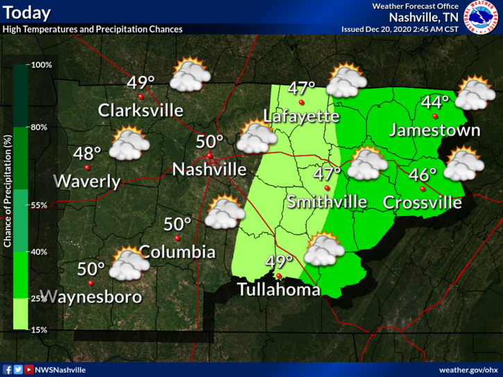
Overnight rain has moved out and we are left socked in with clouds. Good news is that we do start the warming trend today. Should top out around 50 today.

And it’s only going to get warmer from here… read more

Sunny and Cold Before Rain Saturday Night, Warming Up Next Week

Chilly start to the morning with heavy frost and freezing fog in some areas.

We will surpass yesterday’s high of 40 for what that’s worth.

At least we’ll get plenty of sunshine

Another chilly night ahead. Near freezing with areas away from the city dipping back into the 20s. read more

Rainy Saturday.

Many locations across Davidson/Williamson Counties dipped into the upper 20s this morning.

Trivia alert! In 1917 we set our record low, in Nashville and 10° in Franklin.

No record lows in sight.

Clouds may clear this afternoon before it gets dark. It’ll be close. Look for mid/upper 40°s. read more

Sprinkles Unlikely Yet Possible Sunday Night/Monday Morning, Chilly Mornings, Then a Warmup

Most of the fog we had this morning has lifted. We even dealt with freezing fog…

Freezing fogs are not unusual. Light winds, clear skies, and dewpoints close to air temps provide perfect conditions for fog. Add subfreezing temps and a layer of ice can form. Probably too many clouds Monday morning for another round, but fogs and freezing fogs will be possible again Tuesday and Wednesday mornings.

Rest of Sunday

Partly cloudy skies in the early afternoon will give way to mostly cloudy skies in the evening.

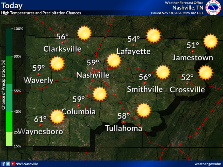
Temperatures will be near seasonal averages with a high of 54. read more

Rain Tonight Transitioning to Splat/Melt Snowflakes Monday, Wind Chills and Temps Drop Below Freezing Monday.

  • Snowflakes mixing with rain possible while we sleep overnight. No accumulation.
  • More snowflakes possible again Monday mid-morning into the afternoon. Accumulation unlikely.
  • Wind chills will drop Monday into the 20°s.
  • Temps should drop below freezing Monday night around dark. Snow should have departed by then, but black ice may form on wet roads late Monday night/early Tuesday morning.
  • Check back in the morning and through the day for updated information.

Rain will continue off and on tonight and overnight.

Forecast rain totals increased slightly from this morning. 1.00″ on average, but local rain gauges will vary. More rain is likely southeast (Nolensville, Antioch, College Grove, Franklin). Less rain is likely northwest (Bellevue, Bordeaux, Joelton, Fairview). read more

Rain Tonight-Overnight, Snow Splat/Melt Monday (maybe a flocking?) with Bitter Cold Wind Chills.

Our quiet November is about to change.

Sunday: All Liquid Precip

Daylight hours Sunday should be dry. Rain expected around sunset or shortly thereafter.

Euro Model shows a 6PM start time.

This is a soaker. NWS-Nashville lists 0.75″ but that’s an average. Data suggests more rain southeast (Nolensville, Antioch, College Grove, Franklin) and less rain northwest (Bellevue, Bordeaux, Joelton, Fairview), but that line could shift a bit here or there and give everyone 1.0″ or 0.5″ or less. Some may see more than 1″. We’d rather see less rain to limit the potential for black ice Monday night into Tuesday morning. Here’s the HRRR model total rainfall: read more

Gradual Warming Trend Into The Weekend, Next Rain Event: Sunday Night/Monday Morning

Few degrees warmer than Tuesday with a high approaching 60 and bright sunshine.

Wash Away!

Notice the “Blue H” over Kentucky.

If you’re a dry weather fan, that “H” is your friend. It prevents air from rising, which is how showers and thunderstorms form. read more

Rain Saturday Night/Sunday Morning, Dry Afterwards

Perfect Saturday

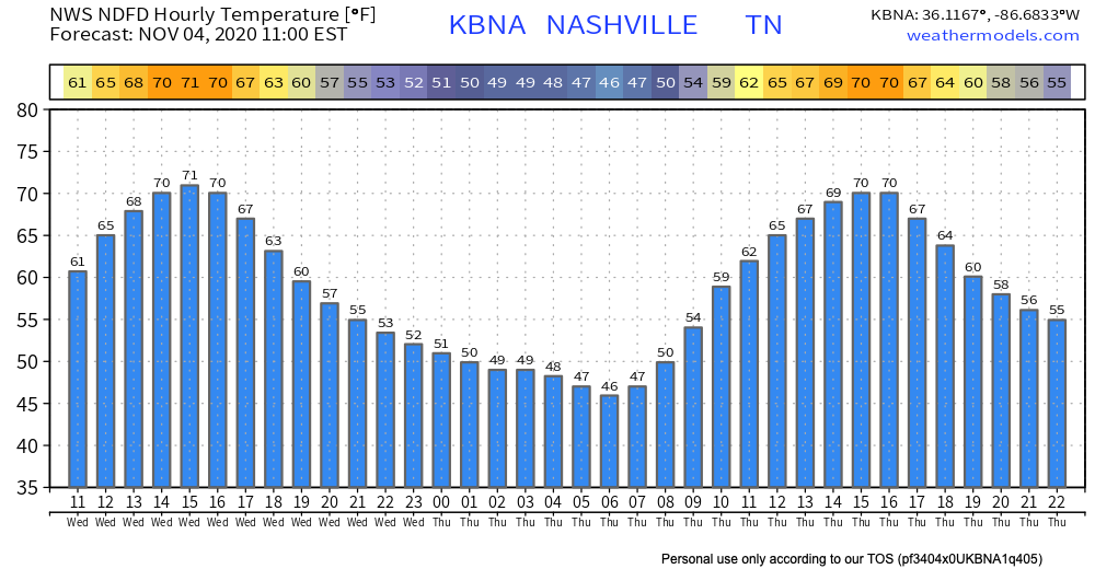
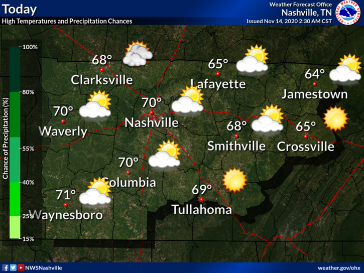
No rain during the day. Mostly sunny and 70!

Couldn’t ask for a better November day!

Details on the Rain

A wind advisory has been issued for the overnight hours.

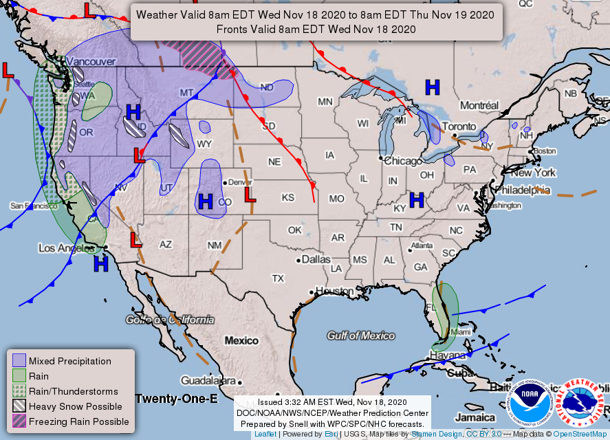
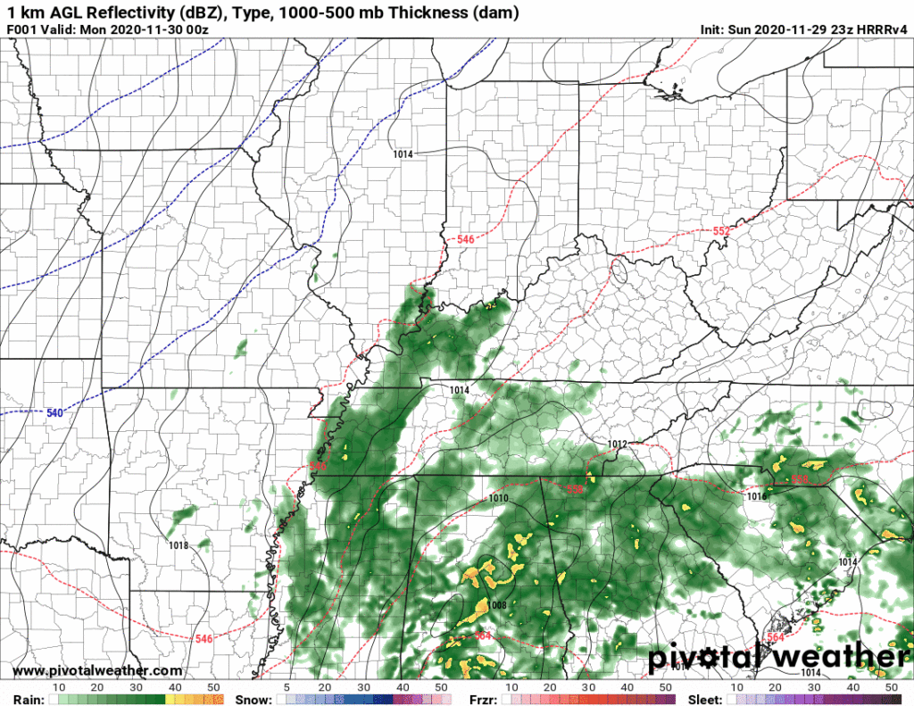
A cold front will swing through overnight. Showers and possibly a thunderstorm will accompany it.

ETA? HRRR Model predicts a broken line of showers between 2AM-7AM, although a stray shower before then is possible. read more

Sunny, Warm, then Mid-Week Rain.

Patchy morning fog gave way to sunshine.

Look closely and you’ll see the swirl of Tropical Storm Eta near Cuba!

We hit the record high yesterday of 80!

We’ll probably come a few degrees short of it today. Forecasted high is 81 while the record is 83 (2005). Perfect for a noon kickoff. Don’t think the visiting Bears will mind. read more

Warming Up and Staying Dry

https://twitter.com/matthewlawsontn/status/1323961298447704072?s=20

Exactly!

High of 71 in November is perfection. It has been a nice day!

We will cool off tonight to the mid 40s. Check out the hourly temperature forecast:

“Big Blue H’s” make meteorologists lives very easy. read more