Sunshine & More Sunshine, Keeping an Eye on Showers Next Week via Remnants of Irma

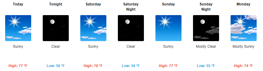
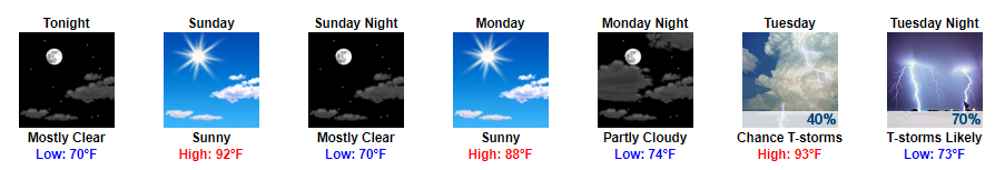
Nice & Quiet Conditions Continue Through the Weekend

First things first, we broke a long-standing record this morning for the record low temperature on September 8th.

Oh My God Wow GIF - Find & Share on GIPHY

For the rest of today and into this weekend, highs will be in the 70s and unnoticeable humidity will continue. Sunny skies will prevail each day with cool overnight temps.

https://giphy.com/gifs/hunts-urban-source-bn9G6jYl51xyo

Friday Night Lights

5 PM – 75° | 7 PM – 72° | 9 PM – 66°

Winds will be fairly light in the 5-10 mph range throughout the evening out of the northeast.

Titans Game Sunday

9 AM – 62° | Kickoff – 72° | 3 PM – 75°

Winds will start off light in the AM before getting a bit gusty around 1 PM. Expect for winds to be in the 5-15 mph range with gusts as high as 20 mph. Other than that, sunny skies and pretty awesome temps for the season opener!

Tennessee Titans Football GIF by NFL - Find & Share on GIPHY

Starting Monday Night, Things Become Uncertain Due to the Remnants of Irma

By Monday evening, all eyes will turn to the remnants of Irma.

It is still several days out, so there are still lots of uncertainty surrounding where Irma will track. At this point, we will probably receive some rainfall no matter what, but how much and how gusty our winds get are the more difficult questions to answer.

Latest run of the GFS brings the beginning of the remnants of Irma into Middle Tennessee by Monday evening.

GFS Loop Monday Afternoon Through Wednesday Afternoon

Euro shows a somewhat similar, but a bit slower, path bringing showers to Middle Tennessee late Monday and continuing into Tuesday. Irma still could potentially be a tropical depression if/when it arrives, which would mean sustained winds in the 20-25 mph range with gusts upwards of 35-40 mph.

The latest NHC track thinks the center of Irma will arrive Wednesday morning.

With all of this in mind, there is still great uncertainty. We will continue to keep an eye on things and let you know of the most up-to-date information as it becomes available.


First Hint of Fall Weather, Cooler Temps and Sunny Skies

Sunshine and Below Average Temps

Let’s start with the NWS Nashville’s AM discussion, there really isn’t a better way to put how the next few days will be:

With yesterday`s showers and scattered thunderstorms just a distant memory, there really isn`t a whole lot to talk about in this morning`s forecast package. We continue to monitor the behemoth Irma and her monster winds in the Atlantic and what she could bring to Middle TN, but the bulk of this morning`s discussion is going to revolve around unseasonably cool temperatures and a mostly dry forecast.

A really fantastic stretch of weather is expected over the next several days. Highs will top off in the mid to upper 70s through the week with virtually unnoticeable humidity.

GIF by Steve Harvey TV - Find & Share on GIPHY

It’s going to feel great y’all.

The more noteworthy thing for this week will be our overnight temps; it’s going to be pretty chilly out there. Lows will fall into the mid to low 50s each night. You may even need a light jacket if you are up early in the morning.

Safe For Work Dog GIF - Find & Share on GIPHY

We may even break some records over the next few nights. Tomorrow’s record low is 49° which occurred in 1988. Friday’s record low is 51° which occurred all the way back in 1898. Both of these records may be tied or even broken.

This Weekend the Awesome Weather Continues

Our pleasant conditions will continue into the weekend. For those with plans to attend the Titans season opener, highs will be in the upper 70s with plenty of sunshine. Sounds like perfect conditions for some football to me.

Into next week, things begin to become a bit more questionable. Our overall weather pattern will have a lot to do with where Irma eventually tracks. Looks like we could see some showers with the outer bands during the beginning to the middle of next week. However, it is still far enough out that there is too much uncertainty to say for sure. We will keep an eye on things for the rest of the week.

Watching You Meet The Parents GIF - Find & Share on GIPHY


Flash Flood Watch Until 7 PM Tonight, More Showers for Today

Wind Advisory Until 1 PM Today, Flash Flood Watch Until 7 PM Tonight

We have several advisories and watches in place currently. The first advisory in place is a wind advisory. Expect for winds to stay a bit gusty at times through the morning thanks to remnants of Harvey.

Wind Advisory Until 1 PM

In addition to this advisory, we are expecting more rain today; so our flash flood watch continues for both Davidson and Williamson Counties.

Rain is expected to continue throughout a good portion of the day. Luckily, no severe weather is expected.

HRRR Loop Through 2 AM

The only concern is how the additional rainfall will mix with our already well-saturated grounds from yesterday.

Our local NWS is expecting for us to see anywhere from 1/2″ to 3/4″ of additional rainfall when all is said and done.

We also have a flood advisory out for Whites Creek in Davidson County.

Bottom line for today and tomorrow is to expect more rain. Showers should begin to clear by the afternoon hours tomorrow with breaks in rainfall here and there until then.

Live on the Green Forecast – Tonight and Tomorrow & Sunday!

The final weekend of LOTG is upon us. Things kick off at 5 PM tonight and 1 PM tomorrow.

Tonight: Expect showers, luckily none will be severe. Tonight’s show was canceled and reset for Sunday.
Tomorrow: May have a few lingering showers to start, but showers should clear as the afternoon/evening continues.

Sunny Skies Sunday/Monday, First Taste of Fall by the Middle of Next Week?

Decent ending to our Labor Day weekend as things dry out Sunday and Monday. Temps will spike back into the 80s with favorable dew points in the upper 50s/low 60s.

By Tuesday, a cold front will dip through Middle Tennessee bringing some showers with it.

GFS Loop Tuesday Morning Through Wednesday Morning

Behind this cold front, highs will be in the low 70s with overnight temps dipping into the upper 50s. Looks like fall is trying to make its first semi-appearance here.

Cat Fall GIF - Find & Share on GIPHY


Flash Flood Watch 7 AM Thursday to 7 PM Friday


Remnants of Harvey Will Bring Showers Our Way for the Rest of the Week

Harvey’s rain is arriving.

Most of the rain of the “first wave” is expected late Wednesday night into the early Thursday morning hours. The HRRR model illustrates:

Tonight’s rain should be relatively light, but persistent.

Heavier rain is expected overnight as a “first wave” lasting into the AM commute.

We could see a few thunderstorms in the mix today/tonight, but no severe weather is expected.

Thursday at 7 AM, our Flash Flood Watch begins. It expires 7 PM Friday.

Both Davidson & Williamson Counties are included in the Flash Flood Watch:

After Thursday morning rain, most models show a break in the rain, where we are rain free most of the day. I’m skeptical we will be totally dry during daylight hours Thursday, and so is NWS-Nashville, which thinks rain is “likely” during the day.

We then await the “second wave” of rain.

Second Wave Thursday Night/Friday Morning Could Bring Heavy Rainfall and Thunderstorms

Sometime Thursday night, the center of what’s left of Harvey (look for the red “L” below) will streak through Middle Tennessee.

NAM3 Model Thursday 5 PM through Friday 9 AM

This is when the heaviest rain will happen. We don’t know exactly when Thursday night it will start. Some models hold it off until late Thursday night. Plan for rain Thursday night, but expect the heaviest rain to arrive late Thursday night and continue into Friday morning.

Not only will heavy rainfall bring chances of localized flash flooding, but we also could see a few strong to severe thunderstorms with isolated tornadoes being possible. The current probability of a tornado within 25 miles of you is 5%. Tropical system tornadoes are usually isolated, weak, and brief.

SPC Day 2 Outlook: Marginal Risk (10% Probability of severe weather within 25 miles of your location)

In addition to this marginal risk of severe weather comes flooding potential.

WPC Day 2 Excessive Rainfall – Slight Risk for Thursday 

WPC Day 3 Excessive Rainfall – Marginal Risk for Friday

As the center of Harvey arrives Thursday night, winds 10 to 15 mph range with gusts upwards of 25+ mph will be common.

Rain Winding Down Friday Night into Saturday

As Harvey pulls north into Kentucky Friday, light rain will wrap around its south side and last most of the day. Expect rain to end sometime Friday night or Saturday morning. We could still see a few stray showers through Saturday, but by then the heaviest rains will have moved off to our north.

After that, things look pretty good.

Takeaways

Most of the rain will fall tonight, Thursday night, and Friday, ending sometime late Friday night or early Saturday. The NWS is expecting storm total rainfall to be around 3.5″ or so.

These comments from NWS-Nashville involve all of Middle Tennessee:

The first wave of rainfall today and tonight will moisten soils considerably, but it is the second wave of heavier rains Thursday and Friday that will stand the greatest chance of producing flood problems for the Mid-State. Creeks and rivers may rise and get to action/flood stage Friday through Sunday, depending on timing of heaviest rainfall and if Harvey slows slightly to drop additional rainfall. In addition, as soils become increasingly saturated over the next several days, local flash flooding could develop, especially in poorly drained low lying areas.

Localized flash flooding is possible. We will continue to update our Twitter @NashSevereWx with the latest information over the course of the next several days.

Live on the Green Forecast – Thursday Through Saturday

The final weekend of LOTG is upon us. Things kick off at 5:15 PM on Thursday, 5 PM on Friday, and 1 PM on Saturday.

Thursday 5:15PM
80% chance of rain — We are hoping for a late ETA of the main/second wave of rain.
Friday 5:00PM
rain should be ending.
Saturday 1:00PM
maybe a lingering shower.

Pack rain gear and go enjoy some music. However, as always, if a thunderstorm is heading your way, remember “when thunder roars, go indoors!”


Dissipating Showers Tonight, Second Half of the Week Looks Wet


Showers Dissipating Tonight, Tomorrow will be Cloudy with Some Showers Possible

Majority of the rainfall has moved out over the course of this afternoon. We do have a few lingering showers around the area, but nothing that an umbrella won’t fix. For those with plans to head out to the Nashville Sounds game tonight, rain should clear by then. We may see a stray shower but nothing to worry about.

Tuesday appears to be another one of those dreary days with highs staying below normal thanks to cloud coverage. Expecting for more showers tomorrow, but probably not as much as we saw today.

Wednesday Through the Weekend Continues to Look Wet

For the remainder of the week, scattered showers will be possible thanks to ample moisture being present in our atmosphere. Highs will be in the mid 80s with dew point temps coasting around the mid to upper 60s.

Another key part of our forecast Wednesday on will be where the remnants of Harvey track. Wednesday/Thursday we will probably see some scattered showers regardless of Harvey, but Harvey could add moisture if it moved our way quick enough.

Friday on really appears to be when Harvey will come into play even more. As our local NWS put this morning, we still have low confidence where the remnants of Harvey will go.

Unfortunately, model solutions for the track and timing have not been consistent. For this reason, our confidence in the weekend forecast is low.

Additionally, our local NWS added this tidbit about what the remnants of Harvey would do if it came our way.

If and when this tropical moisture impacts us, it will enhance rainfall coverage and amounts, but we will not see anything like the impacts being seen over TX.

We will continue to keep an eye on things and let you know the latest information as it becomes available.

Live on the Green Forecast – Thursday Through the Weekend

The last Thursday and weekend of Live on the Green is here. Things kick off at 5:15 PM on Thursday, 5 PM on Friday, and 1 PM on Saturday. A lot of the forecast for this event is still up in the air thanks to Harvey as mentioned previously. It does appear that the latter half of this week will be pretty wet though.

If you have plans to go out to LOTG on either night or day, I wouldn’t let the rain discourage you, but you will probably need an umbrella through most of it.

GFS Loop Thursday Afternoon Through Saturday Evening

This is just one model, but it shows the general lingering wet period expected for the second half of this week.

They’re may be times that we stay dry over this period, and probably will be, but between Thursday night, Friday night, and Saturday’s events I think we will end up dodging showers for a lot of it.


Fantastic Conditions Through the Weekend, Shower Chances Return Next Week


Sunny Skies & Low Humidity Now Through the Weekend

Things really can’t get any better than this for Middle Tennessee as we near the end of August. Highs in the mid 80s, dew point temps in the mid to upper 50s, and no rain chances over the next few days.

No matter if your plans are to head downtown for the Titans game on Sunday, or just a day on the lake, today and this weekend continue to look amazing.

Bruno Mars GIF - Find & Share on GIPHY

Friday Night Lights

Another flawless Friday evening is expected with temps cooling off pretty quickly through the night. Temps will be in the low 80s for any pre-game festivities with temps gliding into the 70s by 7 PM.

Additionally, wind speeds may be a bit gusty through this afternoon into the early evening hours with winds in the 5-10 mph range.

Red = Temperature | Green = Dew Point Temp | Purple = Wind Speed & Direction

Dew Points Increase into Next Week, Enter Scattered Shower Chances

By Sunday, dew point temps will begin to slowly creep back into the low 60s. Monday through mid-week dew point temps will be back in the low to mid 60s. Bring on the sticky air once again.

With these increasing dew point temps also brings increased moisture and therefore shower chances.

GFS Loop Monday Morning Through Thursday Morning

Scattered showers and possibly a few thunderstorms will be possible each afternoon with showers exiting in the evening.

Schitts Creek Ok GIF by CBC - Find & Share on GIPHY

Mid to End of Next Week Remains Uncertain

For remainder of next week, all eyes will be on the probable remnants of Hurricane Harvey. Harvey is expected to make landfall and stay in Texas through the beginning of next week.

Models still remain to be inconsistent with where the system will travel towards the middle of next week. This is what our local NWS said this morning:

Other than an increasing trend in pops late week, the track and impact of Harvey`s remnants are too uncertain to indicate any specific impacts for the Mid State at this time.

Let It Go Idk GIF - Find & Share on GIPHY

We will continue to keep an eye on things and keep you all updated with the latest information as it becomes available.


Sunshine For All and Much Cooler Temps


Sunshine and Cooler Temps for the Rest of the Week

Say goodbye to those highs in the 90s and say hello to cooler and drier temps over the next several days.  Following yesterday’s cold front, expect for highs to only reach the low to mid 80s now through the weekend.

Zach Galifianakis Yes GIF - Find & Share on GIPHY

As for our dew point temps, today will remain a tad bit muggy. However, dew point temps will constantly drop throughout the day, leaving us with dew point temps in the upper 50s by tomorrow.

Prepare for more comfortable days ahead.

Comedy Bang Bang Fools GIF by IFC - Find & Share on GIPHY

Live on the Green – The Weeks, Portugal. The Man, and Spoon (6:15-11:00PM)

This may be one of the nicest evenings we’ve seen for LOTG this year so far. Temps will dip into the 70s by start time with temps falling down into the upper 60s by the end.

No rain is in the forecast either so prepare for a pleasant evening!

Saturday Looks Great, Sunday Maybe Not as Great

Saturday looks to be a continuation of the rest of the week with highs in the mid 80s and dew point temps in the upper 50s.

Slow Motion Yes GIF by MOODMAN - Find & Share on GIPHY

Dew point temps will begin to creep back into the mid 60s range on Sunday while bringing a small chance of showers along with it.

I’m not completely sold on these showers yet, but Saturday does still appear to be the better of the two days this weekend for any plans you may have.

Unsettled Weather Pattern Next Week

For next week, all eyes are on the remnants of Harvey currently churning away in the Gulf of Mexico. This storm is expected to redevelop, possibly into a Tropical Storm, before bringing ample amounts of rainfall to Texas.

What does this have to do with us? Well, models are showing that this system may drift our way afterwards which would mean showers for our entire area.


Cold Front Tomorrow, Cooler Temps By Wednesday & Some Cool Pics From Today!


The Eclipse Has Come and Gone; Mostly Sunny Skies Remain

Seems like we’ve been waiting for this eclipse for quite some time now, but it already come and gone. Here are just some of the amazing pictures we have received this afternoon.

https://twitter.com/omeganon/status/899705806974849024

https://twitter.com/tempestchasing/status/899702535627386881

Keep sending us your pics of the event on Twitter @NashSevereWx !

For the remainder of the day, scattered clouds will be present. Temps will spike back up this afternoon before cooling into the 70s to 80s overnight.

Showers and Thunderstorms Arrive Tuesday & Wednesday

All eyes are on a cold front that will make its way through Middle Tennessee tomorrow. This front will bring much cooler temps and dew point temps.

Ahead of this front, expect to see some showers with a few strong/severe thunderstorms being possible Tuesday afternoon.

GFS Loop Early Tuesday Through Late Wednesday Night  

On the severe front, damaging winds and localized flooding are the main concerns.

Rain chances will continue into Wednesday; however, we will at least begin to feel some relief from the heat. Highs on Wednesday will be in the low 80s with overnight temps dropping into the low 60s.

Is This For Real Good Burger GIF - Find & Share on GIPHY

Yes, those high temp values are real.

Incredible End to the Work Week

Thursday, Friday, and even into this weekend looks fantastic. Highs will continue to be in the low to mid 80s through the weekend. Dew point temps will even be in the upper 50s on Thursday and Friday.

Needless to say, this weekend won’t feel that summerlike, it’ll just be plain awesome.

Happy Tom Cruise GIF - Find & Share on GIPHY


Full Eclipse Forecast for Today, Cold Front Tomorrow, Cooler Temps By Wednesday

[tminus t=”21-08-2017 11:58:00″ align=”left” omitweeks=”true” id=”Solar-Eclipse”/]


Today’s the Big Day!

And just like that August 21, 2017 is finally here.

To answer the question “will a cloud be overhead during totality at my location”, the answer is we do not know. We cannot say whether a cloud will be at a certain location at a certain time. However, this is what we do know about the cloud factor for today.

We do know that clouds will be in the sky during the day and afternoon. Here are what just a few models are showing.

HRRR Model at 1 PM

NAM3 Model at 1 PM

GFS Model at 1 PM

Most models continue to be optimistic on the cloud coverage front.

As for our local NWS, here is their cloud coverage breakdown before and after totality

Clouds will be present, but we just hope that they will not be directly overhead at totality.

Here’s an additional note, enjoy today. While the partial solar eclipse will take place over several hours, complete totality will only last for two minutes.

One last interesting point about the solar eclipse will be our temperatures. Temps are expected to drop about 5-7°F around the time of the maximum eclipse. This dip in temperatures won’t last long as temps will spike back up by the heat of the afternoon.

Red – Temperature | Gold – Heat Index | Green – Dew Point Temp

Showers and Thunderstorms Arrive Tuesday & Wednesday

After the eclipse, all eyes are on a cold front that will make its way through Middle Tennessee. This front will bring much cooler temps and dew point temps.

Ahead of this front, expect to see some showers with a few strong/severe thunderstorms being possible Tuesday afternoon.

GFS Loop Early Tuesday Through Late Wednesday Night  

On the severe front, damaging winds and localized flooding are the main concerns.

Rain chances will continue into Wednesday; however, we will at least begin to feel some relief from the heat. Highs on Wednesday will be in the low 80s with overnight temps dropping into the low 60s.

Is This For Real Good Burger GIF - Find & Share on GIPHY

Yes, those high temp values are real.

Incredible End to the Work Week

Thursday, Friday, and even into this weekend looks fantastic. Highs will continue to be in the low to mid 80s through the weekend. Dew point temps will even be in the upper 50s on Thursday and Friday.

Needless to say, this weekend won’t feel that summerlike, it’ll just be plain awesome.

Happy Tom Cruise GIF - Find & Share on GIPHY


Sunny Skies Through Monday’s Solar Eclipse


Sunshine and Summertime Weekend

A pretty fantastic weekend is in store for Middle Tennessee with highs in the low 90s. Dew point temps will remain in the low 70s.

Sounds like a great weekend to be outside or to take a jump in the pool if you ask me!

Boy Band Party GIF by ABC Network - Find & Share on GIPHY

Monday’s Eclipse Viewing Forecast Remains Promising

Models continue to show favorable conditions for Monday’s Solar Eclipse. This morning, our local NWS broke down an hour by hour forecast for temps and cloud coverage during the big event.

I want to re-emphasize that while we are optimistic about the totality viewing, there may be a few clouds in the sky at that time.

Remember, Downtown Nashville’s totality begins at 1:27PM and continues until 1:29PM. For more information about the upcoming solar eclipse, visit the two websites below.

http://www.weather.gov/source/crh/eclipse.html?sid=ohx

https://eclipse2017.nasa.gov/sites/default/files/interactive_map/index.html

Showers Begin to Return Tuesday and Beyond

Moving into the rest of next week, we begin to see a few more decent shots of rain. Tuesday and Wednesday both appear to be pretty wet days with thunderstorms being possible Tuesday night.

GFS Model Loop 7 AM Tuesday Through 7 AM Thursday

Beyond Wednesday, things appear to dry out the remainder of the week.