Severe weather isn’t easy for our atmosphere to create. For severe weather to occur, there are ingredients that must be present at the “right” place at the “right” time and at the “right” amount. If these ingredients don’t line up in place, time or amount, we’re left with less than. But, who’s disappointed?
Author: Andrew
Tornado Watch Until 7:00 am For Davidson County; More Severe Weather Possible Later Today
Flash Flood Potential and Low-End Tornado Threat
Flash Flood Watch In Effect Beginning at 7:00 pm Tonight

The latest rainfall estimates from NWS Nashville put us in the 3-4 inch range with locally higher amounts possible through Tuesday night.

While heavy rainfall is possible at any point during the Flash Flood Watch period, NWS Nashville highlights two periods where rainfall could be heaviest.
Nice Few Days Ahead, Low Rain Chances Returning Early Next Week
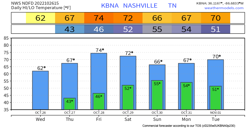
No weather concerns to talk about through late weekend. Outdoor activities are a go!
Front Brings Showers Sunday Into Next Week
A front will sag southward toward the Kentucky border on Sunday. The front will take advantage of some moisture and produce some isolated to scattered showers. Low-ish resolution Euro model illustrates:
Storms Possible This Evening, Rain Chances This Weekend Into Next Week
Two Tornadoes in Davidson County on Tuesday
Two tornadoes touched down in northern Davidson County on Tuesday morning, according to a damage survey by NWS-Nashville. The first along a W to E path just north of I-24/Joelton. The other along Lickton Pike/Old Springfield Pike/Hwy 41 just N of Goodlettsville. Both were EF-0. They both occurred within the tornado warning that had been issued and were from the same storm. The first tornado touched down, lifted, then touched down again as it moved east.
Brief Shot At Storms Thursday, Weekend Rain Chances
Yesterday’s Severe Weather
Numerous National Weather Service damage surveys will get going over the next few days to determine what damage was caused by tornadoes and what damage was caused by straight-line winds. The damage can look similar, especially with weak rotation as we saw yesterday. But, trained eyes will sort it out.
Compassionate Grit
One year ago, many of us were beginning to understand the magnitude of what had happened. We had watched the horrific scene of a strong tornado moving through our city live on our screens hours before, but this wasn’t your average tornado video off YouTube. It was our city, our home, our friends, our neighbors.
It’s Gonna Rain
While ever-shrinking piles of plowed snow hang around to remind us of the big snow that was, we look ahead to a multi-inch rain that could bring flooding.

It wasn’t too long ago we were looking at snow accumulation maps that resembled this, but rain in these amounts is a different ballgame. Much more water will fall from the sky and will likely run right off into local ponds, streams, creeks and rivers due to the saturated ground.
Snow Moving Out; Clean Your Ride Before You Drive
If You Read Nothing Else
Please clean your ride before you drive. How long does it take?
In those 8 minutes, you prevent doing this to the unsuspecting person behind you:
Be cool, and clean the ice off.
It Snowed!
After messing with us a few times last night with some brief sleet, the atmosphere finally had mercy and unleashed a snow event. Many received 3-4 inches of new snow on top of the crusty ice, leaving several inches of sleadable powder with snow continuing today. It’s been a hot minute since we’ve seen those snow rates we had last night and reminded many of us of years like Jan. 2016 or even Jan 2003. Although our totals this time were a little less, it came down quickly and was fun to watch.
Watching for Unlikely PM Storms Today, Mixed Precip Chances/Cold Early Next Week

Sunshine Incoming
As of 1:00 pm, a cold front is moving east through west TN. The widespread clouds we’ve seen so far today are also moving east, leaving us with what could be a partly sunny afternoon.
In some scenarios, this would destabilize the air above our heads enough to create damage-making severe weather. However, today, the general mood of computer models and forecasters is somewhat chill.