Today
After the soaking we’ve had over the past few days, we have a chance to dry out beginning today. Plenty of sunshine and a high temp of 47°. Not very warm, but the sun will help. Temps continue to climb over the next few days.

After the soaking we’ve had over the past few days, we have a chance to dry out beginning today. Plenty of sunshine and a high temp of 47°. Not very warm, but the sun will help. Temps continue to climb over the next few days.
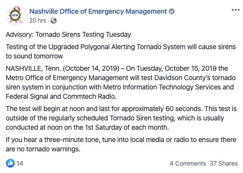
Today’s weather is glorious. But, first, a word from our sirens.
Many of you heard Metro’s tornado sirens blow at noon today. You were like, “it’s not Saturday.” That would be correct. The Office of Emergency Management tested the sirens today as a part of the system upgrade. The gist of this upgrade is that the only sirens that will activate are ones located inside the tornado warning. Good times!

Lots of sun. NWS is expecting a high of 86° this afternoon, but with the dewpoint at only 56°, it’s going to feel about as nice as 86° can feel.
Yes, Pam, it is.
Still cloud-free, we’ll drop down to around 63° overnight. Still very comfortable.
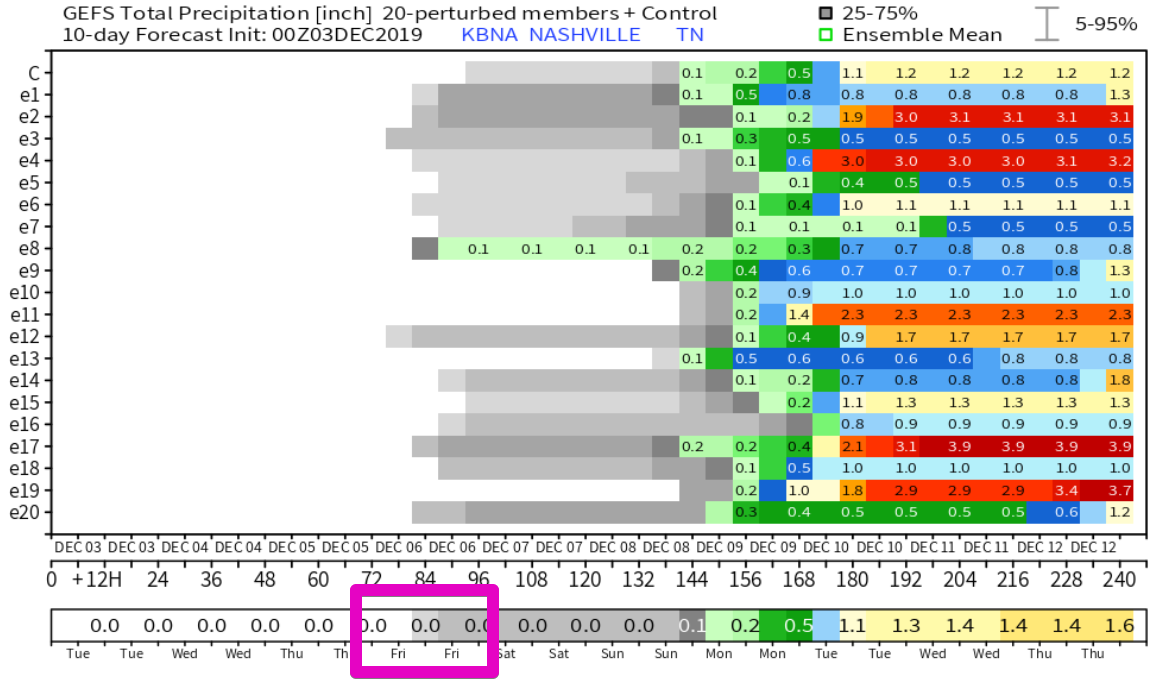
No rain is expected through the weekend and even into next work week.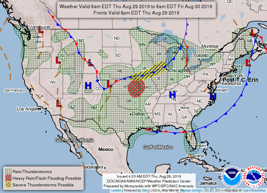
A decent high pressure system (blue “H”) is camping out above us, putting a lid on storm development. Looking at the 7 day qpf (rain) forecast map, it’s pretty obvious where the high pressure system is forecast to hang on.
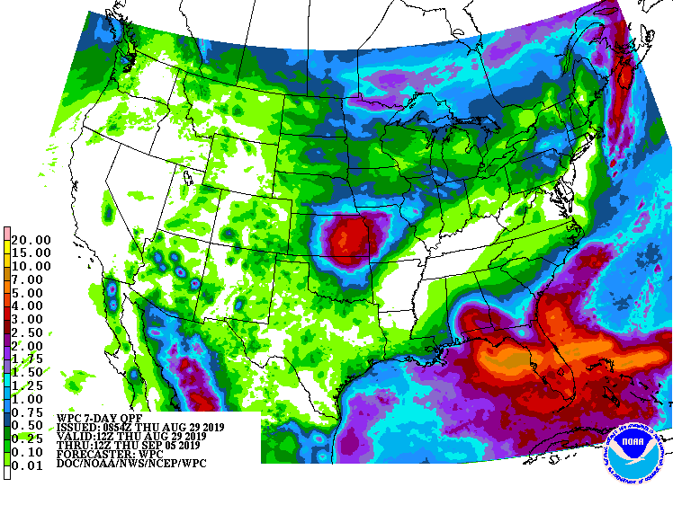
If you’re looking at the map thinking “that looks like next to no rain for us and a lot for Florida.” You’d be right. We’ll have to see if slight rain chances creep into our area by the middle of next week, but for now, the forecast is dry.
By now you’ve probably heard of Hurricane Dorian. Without getting into the weeds, just be aware that the current forecast from the National Hurricane Center has it reaching Category 4 strength and impacting the Florida east coast over the weekend. If you know folks down that way, make sure they have this info. This advisory as of 11:00 am AST. 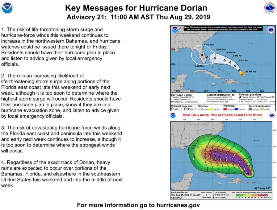
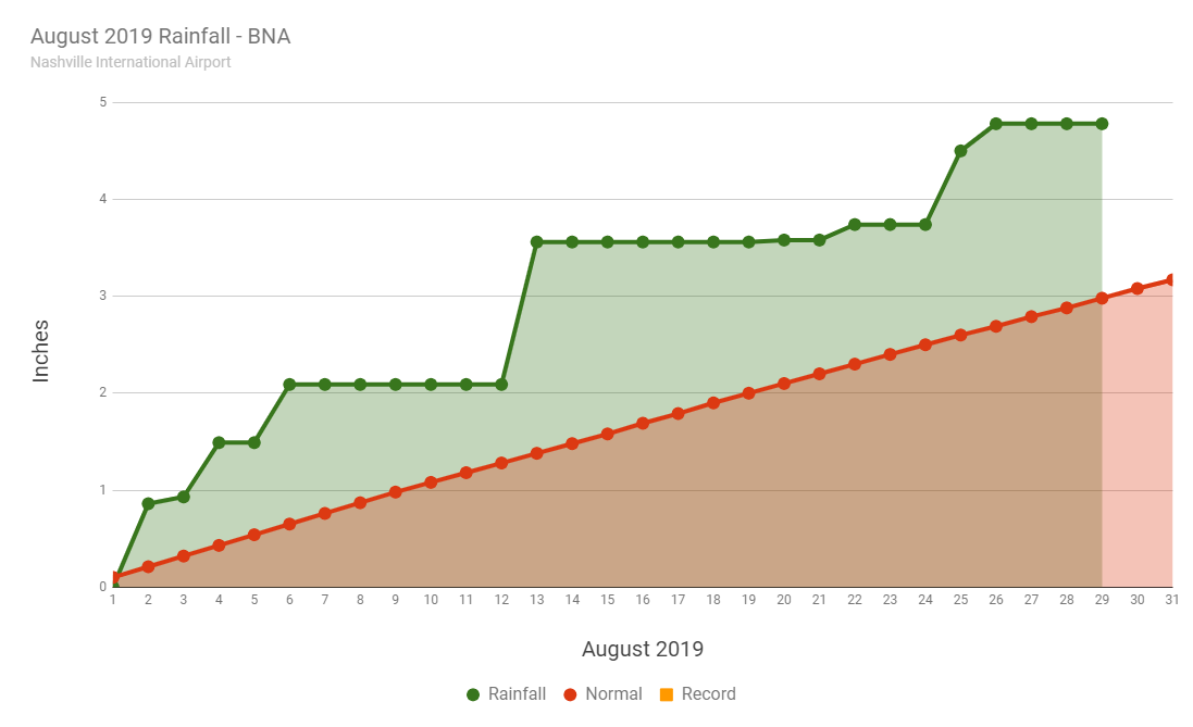
Assuming we don’t get any more rainfall during August, we’ll end the month above normal at BNA.
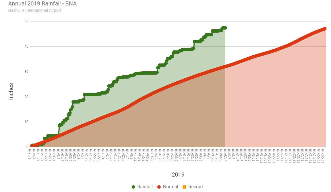
For 2019, we’re still way above normal on precip at BNA. In fact, if we didn’t get another drop of precip between now and the end of the year, we’d still end up just above normal. Buuut, let’s not wish that on ourselves.
As always, we’ll be over on Twitter @NashSevereWx. Have a great day!

@NashSevereWx Hail in the Brentwood/ Nipper’s corner area! pic.twitter.com/KJbaxbD0ix
— Bianca Skartland (@BiancaSkartland) June 27, 2019
https://platform.twitter.com/widgets.js
We could see some similar storms today, although not guaranteed. Some ingredients are in place (nerd speak: deep instability and strong lapse rates) for storms to get a little angry. Also, there are a lot of outflow boundaries laying around from last night’s storms that could enhance lift in areas where they lurk. Outflow boundaries are the winds at ground level that ripple out of dying storms as they collapse. They can be the focus of additional storms.
The HRRR model thinks it will look something like this. Loop is from 1:00 pm – 9:00 pm.
If you have outdoor plans this afternoon and evening, watch for dark clouds. Be suspicious of them. We’ll be watching radar.
The Storm Prediction Center believes there’s a 5% chance these storms will have winds of 58+ mph within 25 miles of you. Lightning is the big thing to watch out for. Yesterday, a lightning strike hit right in the center of Smith Park in Brentwood from a distant storm. Those on the trails probably won’t soon forget what that was like.
High temps should get to about 90° today.
Tonight, storms should start to wind down by 10:00 pm. We’ll drop to a sticky 69°, especially sticky for those who receive rain today.
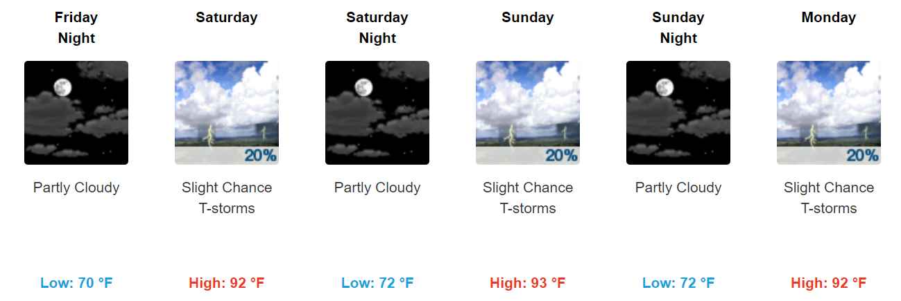
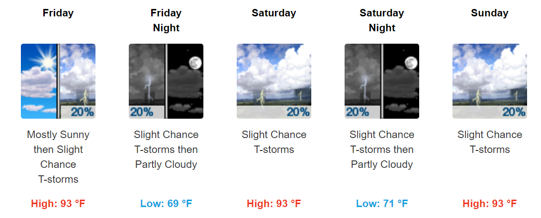
The energy that is helping today’s thunderstorm development will push back to the west as we get into the weekend. The expectation is that the rain/storm chances will go down beginning Friday….but won’t be zero. We’re left with a 20% of storms Friday and a high of 91°. Heat indices will start to climb into the mid-90s, however, as the dew point creeps upward.
Small storm chances will remain with us each day through the weekend and into next week. We expect storm chances to increase by the middle of next week as energy pushes in, but we’ll see how that pans out as we get closer. Take frequent breaks and drink lots of water! It’s going to be hot!

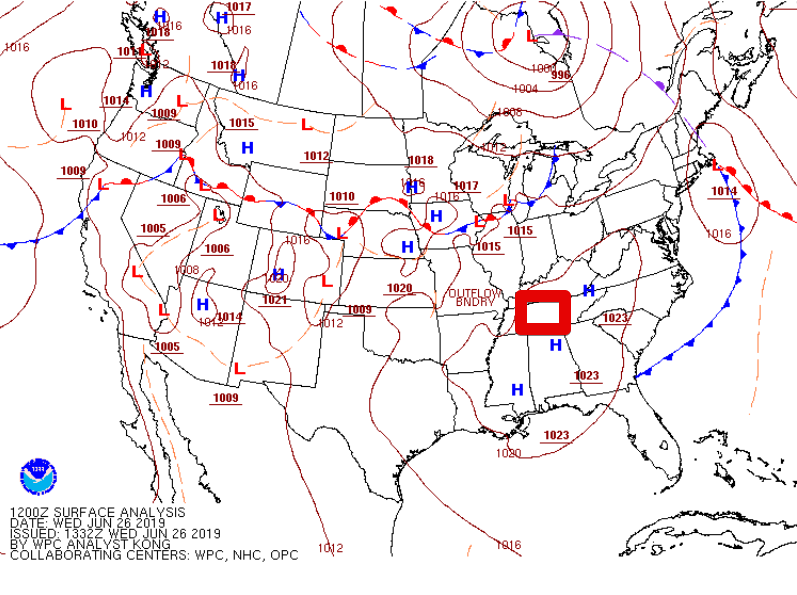
Notice the H’s near us on the map. High pressure is in control today. This typically puts a lid on the atmosphere’s willingness to storm. While it’s possible the western half of the state could see a brief storm, the odds are against any one place receiving rain. Temperatures will be slightly above average with a forecast high of 91°. There won’t be much of a breeze to provide relief, so take frequent water breaks!
*If* anything bubbles up on radar over us, which is unlikely, it will quickly fall apart leaving us with a muggy evening and temps settling down to around 70° by daybreak Thursday.
Rain/storm chances go up slightly on Thursday as the ridge of high pressure slips off to our E ever so slightly. Rain chances will be around 20%, so not everyone will see these typical summer-time pop up storms. Temps go up, too. 93° is the forecast high. HRRR illustrates the possible storms. Loop from 1:00 pm – 7:00 pm.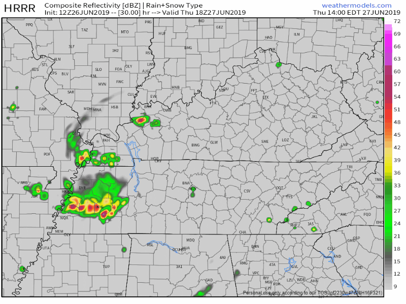
Afternoon and evening storm chances remain in the forecast through the weekend. It will be toasty with highs in the low to mid-90s. If you’re lucky enough to get a thundershower to cool you down, the sun will then come back out and steam the neighborhood up. Summer is definitely here in Mid-TN!
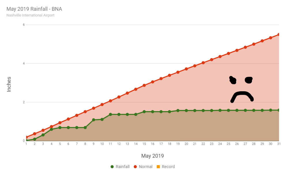
May was D.R.Y. It’s usually our wettest month of the year. It turned out to be our driest month year-to-date by far. The graph below tells the story pretty well. We received about 29% of our normal rainfall.
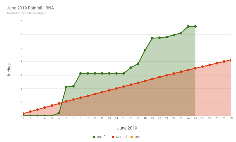
We’ve snapped out of our dry episode for June, it seems. We’re currently 3+ inches above normal for the month.
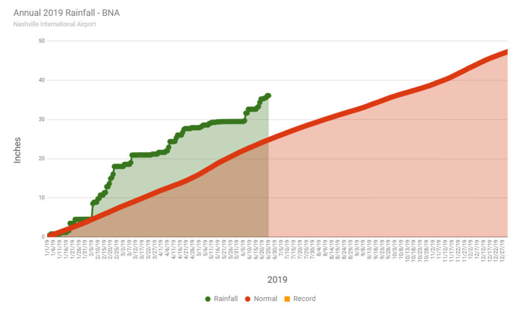
For 2019, we’re still in a big surplus due to the huge rains we had early in the year. Remember when we had over 13 inches of rain in February alone? For the year, we’re about 11 inches above normal.

Last week, I spent several days at various places on the Pacific coast. The weather was fantastic. Today in Nashville is awfully close to what you find out west this time of year. If you took the day off, are at camp this week, or even mowing the grass, good move. This is about as good as it gets in mid-June.
Expect an afternoon high of 77°, but the dew point is only 48° (as of noon). Put out the hammock and enjoy…safely.
Tonight, we should dip down to 53°. The record low we’d be aiming for is 48° back in 1968. Not record breaking tonight, but certainly nice.
Our temps start to go up, but the sun stays put. We should hit 81°. Dew points should stay in the upper 40s again. Another nice day!
If you have outdoor plans Friday evening, go for it. Lows will dip down to around 63°. No rain.
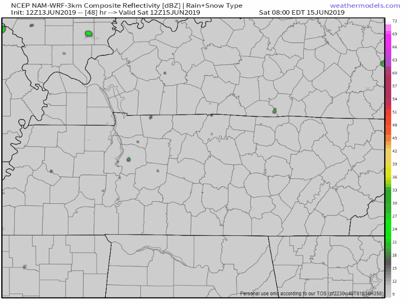
We crank the heat up a little higher on Saturday, up to 88°. Moisture will be on the increase also, not in the form of rain, but in the form of humidity. Dew points jump into the low 60s, which will be noticeable. We think rain will stay away for Saturday as the next system approaches. The 3km NAM model thinks the rain situation will look like this (7am – 7pm Saturday).
On Sunday, a front will approach from the north and will stall out. It’s hard to get fronts to really push through our part of the country this time of year. What we’re left with is a decent amount of moisture, decent instability (especially during the afternoon) and daily rain/storm chances. Because this system stalls, rain/storm chances will likely hang around for quite some time. Severe weather doesn’t look to be a concern right now. If you’re down at Roo, follow all instructions if lightning becomes a thing. If there’s any day when it could, Sunday is it.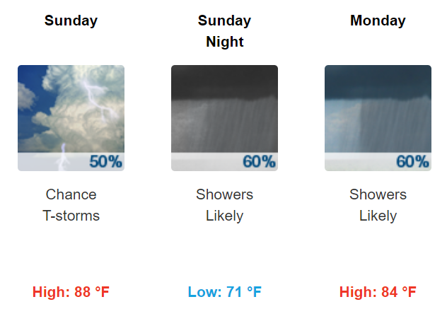
As we’ve been saying for several days, severe storms require certain ingredients. Most of them were in place, but we were lacking enough cold air aloft to get good updrafts going.
Weather balloon data is back! Shows lapse rates too low for severe weather here. Temps aren’t cold enough aloft to cause clouds to rise/lift fast enough to get robust vertical motion needed to create a storm capable of producing a rapidly rotating updraft (aka tornado).
We are expecting showers and thunderstorms today as a strong storm system moves through the Upper Plains and Great Lakes region. The system will drag a cold front across our area today bringing storms, some of which could be severe.
The Storm Prediction Center upgraded us overnight to an “Enhanced” risk of severe weather, which is a 3 out of 5 on the risk scale. This translates to these probabilities of seeing “x” within 25 miles of you today.
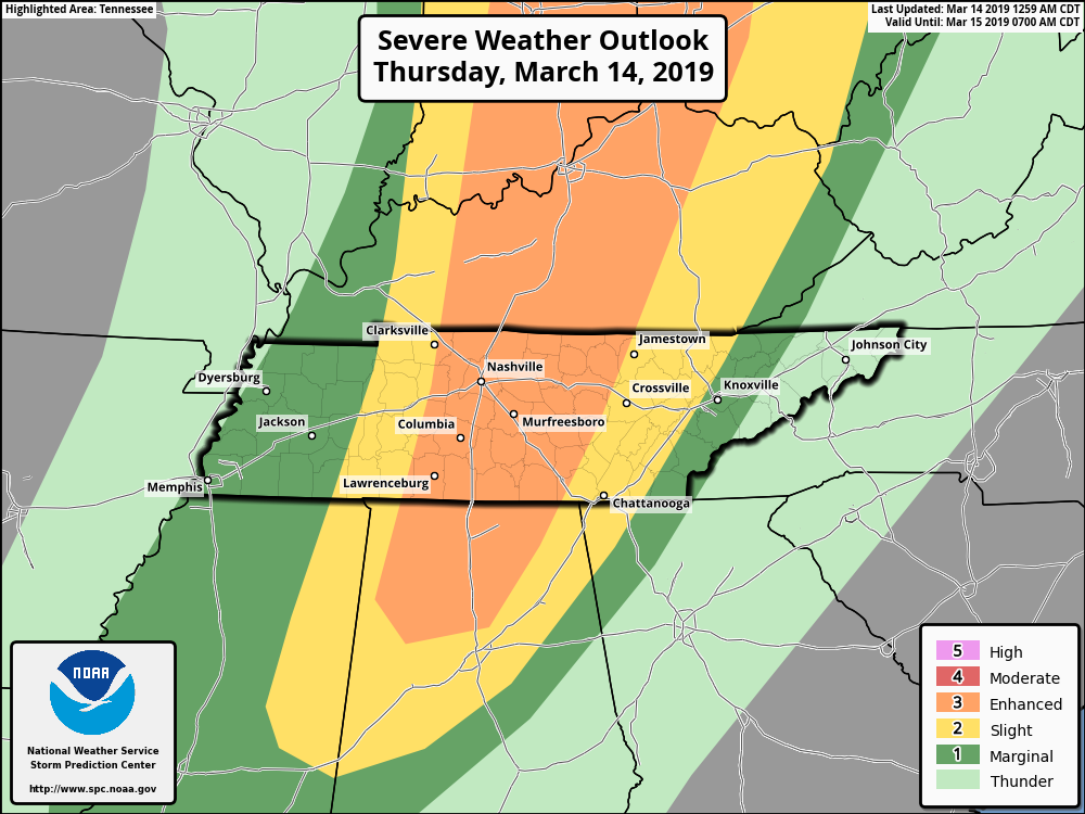
Today will be another warm day with morning lows around 61°, but highs warming to around 73°. Southerly winds could gust even higher than today as a strong system approaches from the west. As far as storms go, let’s start general and work toward specifics.
SPC’s risk translates to a 15% chance of seeing severe weather within 25 miles of you. To break it down further, here are the chances for each severe weather type, again, occurring within 25 miles of you.
Or to say that another way,
The HRRR model below illustrates two potential rounds of storms, with varying severe potential.
The first round arrived at the Tennessee River after midnight, but fizzled as it approached Nashville during the wee hours. If the HRRR solution is “mostly right” (no model is exactly right), round one won’t be a problem for us. If the line keeps trucking east, it could be a bumpy night. We don’t think this will happen, but we’ll watch it closely.
Round two arrives around 4 pm, give or take a few hours. This line does look to push all the way through our area and is the main severe weather concern for Today and the reason the above severe probabilities were issued by the Storm Prediction Center. HRRR model is below and runs through 5:00 pm this evening.
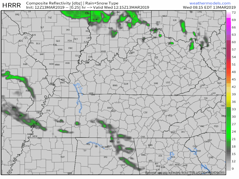
NAM3 model agrees with a 4 PM ETA, plus or minus a few hours.
The line doesn’t look all that robust on these models though. Begging the question:
Are the Ingredients There For Severe Weather?
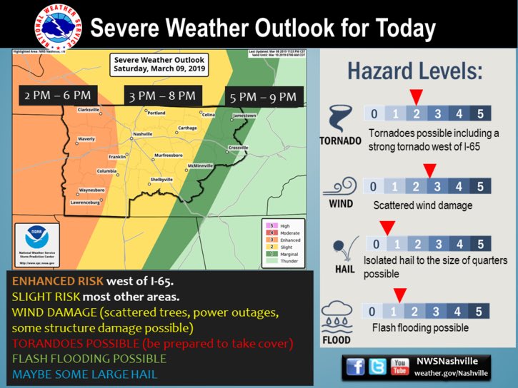
The Storm Prediction Center has assigned a “2 out of 5” risk category for most of us on Saturday. Areas W of 65 has been in an Enhanced or “3 out of 5” risk category.
As a low pressure system progresses through the Plains and upper Midwest, it will drag a cold front through Middle Tennessee tomorrow. With this system will come some storm ingredients.
Highs Saturday will be noticeably warmer than today. We’re forecast to top out at 67°. So, that’ll be nice.
For severe weather around here, we need a few ingredients. Namely, instability (CAPE), wind shear, lift, moisture. We will have plenty of moisture and plenty of lift (from the cold front).
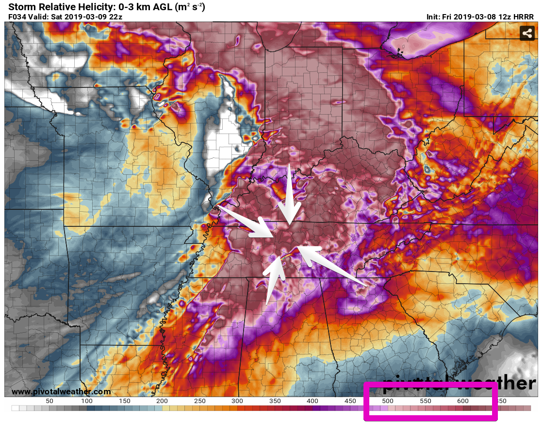
Let’s focus on wind shear and instability.
The wind shear is crazy high. Like, really high. For severe weather, in the right environment, numbers in the neighborhood of 250 are sufficient to create rotating, strong/severe thunderstorms (note not all rotating storms make tornadoes, but they can make tornadoes). The HRRR model thinks tomorrow we’ll see shear numbers of 600, 700, or even 800. These numbers are obviously sufficient for severe weather, and maybe even too high.
Instability – measured by CAPE – is a different story. The same HRRR model run shows sufficient CAPE to make storms west of us, but it falls off significantly as the system approaches I-65….but the CAPE is not zero. Model animation runs from 10:00 am to 6:00 pm Saturday.
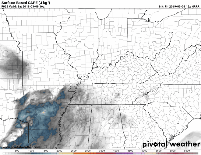
CAPE/instability will be high enough that we’ll have our eyes peeled to the west for sure. And if that CAPE hangs on a little longer, it’ll team up with other ingredients and create very strong/severe storms.
You must be logged in to post a comment.