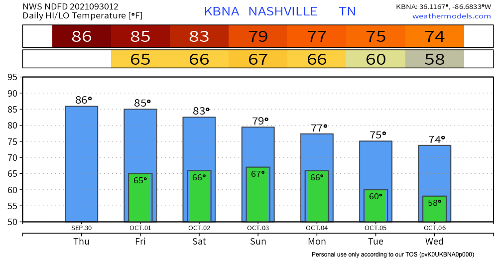
Very warm few days ahead for October. Well above average highs in the mid 80s (on the order of ten or so degrees warmer than usual). Muggy dewps stick around for the week.
Hold on to your hats… expecting wind speeds between 10 and 20 mph throughout the day (gusts up to 30 mph possible!). A few clouds in the sky, but otherwise a sunny, warm day. Nothing to ruin any outdoor plans.read more
I hate to be the bearer of bad news, but it still isn’t sweater weather yet. Temps today in the mid to high 80s, and dewpoints hanging on at the high 60s. A bit sticky but definitely could be worse. Temps today are falling right below the record high for today. read more
If I were to be giving this forecast of mid 80’s and no rain in the middle of July, we would all probably be pretty okay with it. Instead we are in October, and I think it is safe to say most of us are all tired of the mid 80’s and ready for PSL weather. read more
Temps and humidity are sticking to the trend today – temps in the high 70s and dewpoints in the high 60s (so sticky, but not unbearable).
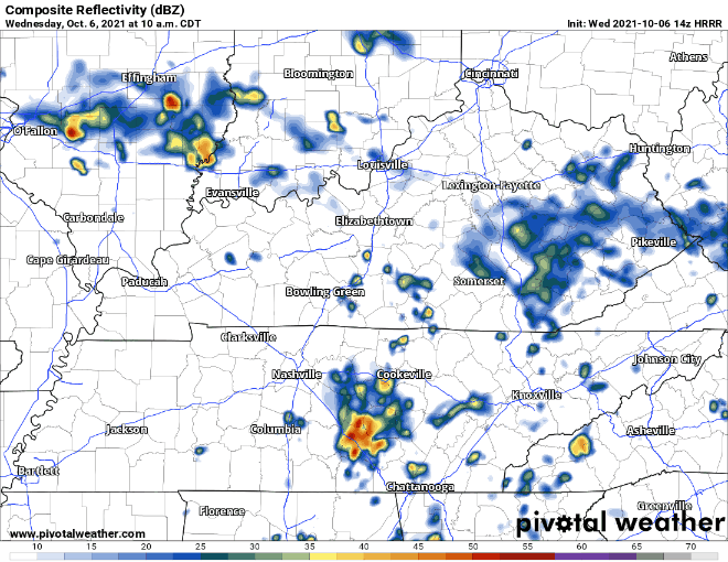
The NWS said that some afternoon pop ups are possible, but HRRR shows most of the fun weather happening to our east. In their words, “Don’t think it’ll be widespread, but we’ll probably see some pavement wetters prior to sunset this evening.”read more
After a few rainy days, we enjoyed a mainly rain-free day except for some mist this morning. The rainfall is stacking up.
After yesterday's rainfall, Nashville's year-to-date rainfall stands at 52.17". We are currently 12.59" above normal in 2021. Normal rainfall for an entire year is 50.51", so we could go dry for the remainder of 2021 and still finish with above normal rainfall for the year.
Guess what… we’re warming back up. Expect no less when it’s Fall in TN. One of these days we won’t have to rely on rain to bring us more Fall-like temps.read more
Showers and storms look pretty widespread today. They look to hang around through the overnight hours. HRRR not showing a lot of breaks from the rain today.
No gaps in rain = rainout potential. Outdoor plans don’t seem like they will fair well. Nothing severe is expected with these storms, but don’t rule out lightning and the occasional strong gust of wind.read more
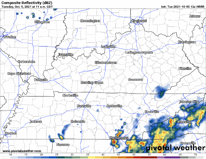
Much quieter today after a wet weekend. There is a possibility of isolated showers in our area. Any rain should be light in nature, not rainout-quality. HRRR thinks most of the action will take place to our southeast.read more
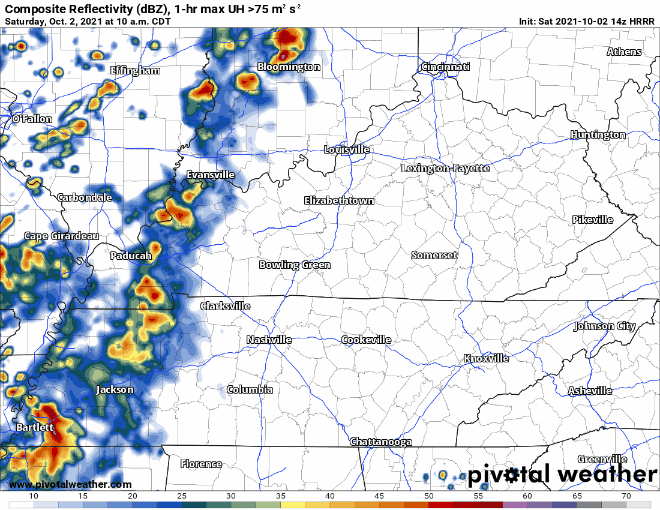
Rain from this morning will continue off and on today through the afternoon. Off/On rain and storms should end around 7 PM. See HRRR below:
There is a lot of moisture in the atmosphere, so some of these showers and storms may lead to heavy downpours. WPC thinks there is a low chance (5 – 10%) for flash flooding to occur in Davidson & Williamson counties. read more
Temperature highs will be in the low 80’s and lows will be in the high 60’s. Chances for scattered showers are possible today (HRRR shown below).
The model is showing that some showers pop up around 5 and are off and on through the evening. Rain today and tonight should not be heavy, but we can’t rule out a rumble of thunder.
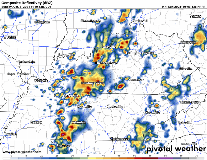
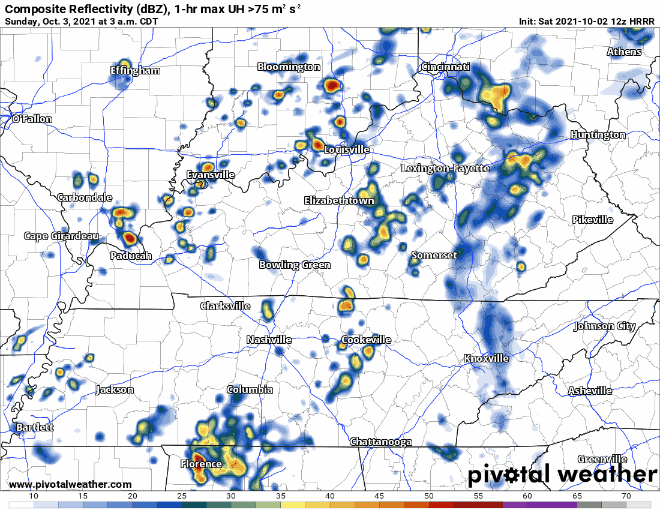
Sunday = Rain
Rain is expected in the early morning on Sunday. Rain continues off and on through lunchtime or maybe mid-afternoon (3-4 pm). The evening will be mostly overcast with still a chance for light occasional showers later into the night as things move out.
Some of the Sunday rain could be on the stronger side. The only concerns would be strong wind gusts and heavy downpours.
Rest of the Week
A closed low will circle around our area… see the morning AFD for an explanation.
A shortwave
will dive south out of Minnesota/Wisconsin toward Arkansas Sunday
night and quickly become a closed low by Monday evening. The
closed low will spend the rest of the work week meandering around
the Southeast and eventually the Ohio River Valley. This will put
us in a cloudy, cooler, and wetter pattern than what we have seen
over the past week. The highest PoPs areawide after Sunday will be
Tuesday afternoon as the upper low lifts back north and westread more