Ice missiles fly off the tops of cars and truck and onto the windshields of cars and trucks behind them. These are this weekend’s biggest hazard. Sometimes the ice doesn’t missile backwards causing property damage or an accident. Sometimes it slides forward and covers your windshield while you are driving. Clear the top of you car and truck before going out.
Month: February 2021
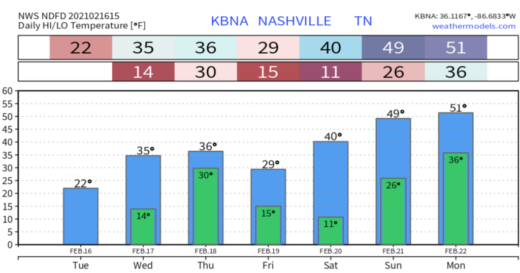
Sunshine Returns, Warming Trend Starting This Weekend
Let’s Start With Something Important…
Clean off your car.
It’ll only take a few minutes to do:
And keep windshields from looking like this:
Sunshine Returns
The GOES-East satellite still shows some snow cover this morning.
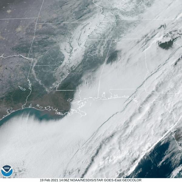
The National Weather Service estimates 3 to 4 inches of snow fell between Wednesday and Thursday.
Snow Moving Out; Clean Your Ride Before You Drive
If You Read Nothing Else
Please clean your ride before you drive. How long does it take?
In those 8 minutes, you prevent doing this to the unsuspecting person behind you:
Be cool, and clean the ice off.
It Snowed!
After messing with us a few times last night with some brief sleet, the atmosphere finally had mercy and unleashed a snow event. Many received 3-4 inches of new snow on top of the crusty ice, leaving several inches of sleadable powder with snow continuing today. It’s been a hot minute since we’ve seen those snow rates we had last night and reminded many of us of years like Jan. 2016 or even Jan 2003. Although our totals this time were a little less, it came down quickly and was fun to watch.
Winter Storm Warning Wednesday–Thursday: Timing, Impacts, Other Details
More Snow Beginning This Afternoon
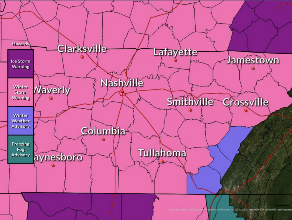
Road conditions are still extremely hazardous across Middle Tennessee.
Enjoy the sun this morning but don’t expect anything to melt. High temperatures will be hard pressed to make it above freezing. Anything that falls today and tomorrow will sit on top of this stubborn layer of ice.
This Week’s Second Winter Storm Watch: Timing, Ranges, Amounts, Uncertainties.
The 18z HRRR model run thinks snow will pass north of us Wednesday morning. By sundown Wednesday night, we begin several hours of snow ending around 1 AM Thursday morning. Then a pause until sunrise, when a sleet/snow event begins then transitions quickly back to snow and continues at least through noon Thursday. Then the model cuts off.
Very Cold Today, More Borderline Sleet/Snow/Rain Arriving Wednesday & Hanging Around Thursday.
It is bitter cold out there with the highs only reaching 22 degrees today. Wind chills no more than 10. The only snow removal will be manual.
Another Round of Snow, Sleet, and/or Rain Wednesday and Thursday
Models disagree where the snow – sleet – rain line will be. Early this morning NWS-Nashville summarized it like this:
Snow, Sleet, or Rain Wednesday Night into Thursday? When Will All This Ice Melt?
First a personal note. I put on a guy on blast on Twitter this afternoon. I shouldn’t have. I got frustrated because I thought his criticism was unfair, and for a minute I thought I was in court. Those who disagree with me or don’t like the way we do things nevertheless deserve my respect. Dragging anyone’s tweet out in front of our audience out of anger and revenge in order to shame them to try and win an argument is not cool. What I did was, and is, wrong. Twitter feuds drive a wedge between us, no minds change, we all just end up angry. I apologized to him (to his credit, he was the bigger man and reached out to me first). The truth is my pride in what we built made me a jerk. I should always be kind. I’ve been given grace, and I did not return it. David.
Winter Storm Warning - Charge Your Mobile Devices!
Significant Ice Accumulation AND Snow
A Winter Storm Warning is in effect for Davidson and Williamson Counties until 6 AM CST Tuesday morning.
This afternoon:
Sleet and freezing rain will continue through the afternoon, with the snow line inching our way as well. Snow is currently in west TN as of noon.