
Shorts Sunday
Warm air is being pumped in by south winds, high 66°, no doubt you’ll see people rocking shorts and flip flops today.
Windy & Wet Monday
Winds sustained 15-20 MPH, with gusts to 30-35 MPH. This will blow over lightweight outdoor stuff.

Warm air is being pumped in by south winds, high 66°, no doubt you’ll see people rocking shorts and flip flops today.
Winds sustained 15-20 MPH, with gusts to 30-35 MPH. This will blow over lightweight outdoor stuff.
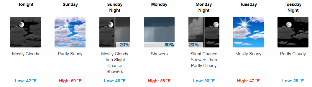
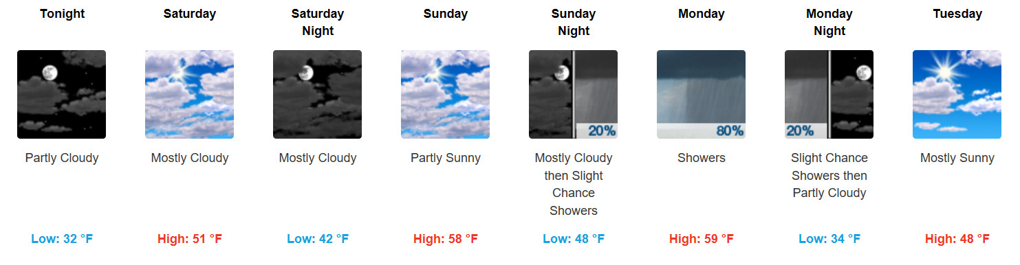
Happy weekend! This weekend looks fantastic for any outdoor plans you may have. Highs today will top off in the low-50s before reaching into the low-60s on Sunday. Enjoy the amazing weather!
https://giphy.com/gifs/veep-3o7qE32pRVNYJYKGBO
Happy Friday, everyone. Southerly flow is returning to the area and will continue pumping in warmer air. Afternoon temperatures will peak in the mid 40s, dipping into the low 30s tonight.
Saturday will be a warmer repeat of today, with some additional clouds filtering in from the south. Sunday is a carbon-copy of Saturday, with temperatures climbing into the lower 60s!
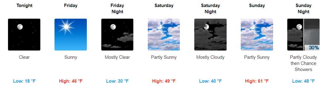
After the bitter cold temperatures we’ve had, the end is finally in sight. Today and tonight will still be on the chillier side with highs in the upper-30s and overnight lows in the teens.
Starting tomorrow, temps will climb into the 40s before reaching the low-60s (yes 60s!) on Sunday.
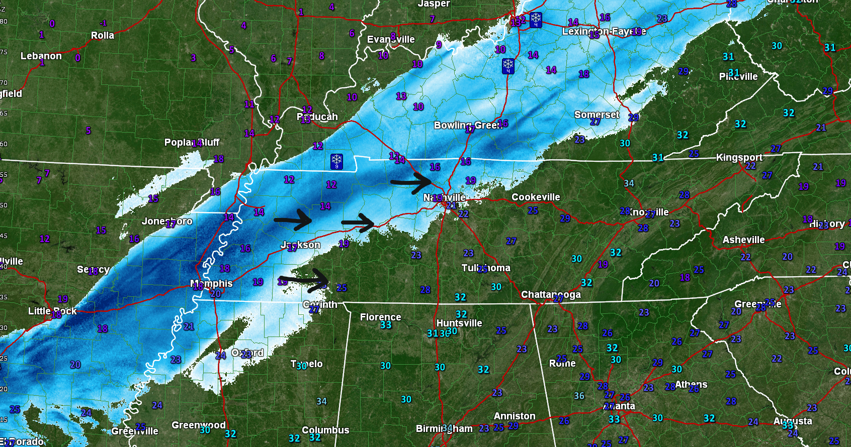
A batch of snow showers have developed across the area, but are slowly dissipating on our approach to noon. The how and why:
There are a few small bodies of water north and northeast of us where this process can happen, if the winds are right. This happened a few weeks ago here too. pic.twitter.com/NzCqYAWQt1
Thanks for all the snow total measurements sent today to #tspotter !
So far, four reports of 3" of snow in Davidson Co., a fifth report 2.7". Three reports of 3" in Williamson, one 3.5" in Brentwood. Several measured less snow, thank you!, nothing under 1".
Some may have woken up thinking “Where’s the snow?”
It’s coming. Recall last night this was going to be a slowly-falling snow over a 9 to 12 hour period. We’re not even halfway through that window right now.
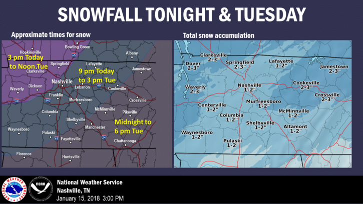
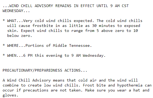
We are under a Winter Weather Advisory.
NWS Nashville has bumped up snowfall totals slightly for our area, taking into account any heavier pockets of snow that may develop overnight and tomorrow morning. We’ve already seen this system over-perform in portions of north Arkansas and southeast Missouri today, so higher amounts cannot be discounted.
As I write, radar indicates a weak clipper system producing flurries in Missouri and north Arkansas. As it creeps east into Middle Tennessee, it should encounter low moisture content. Therefore, at most only flurries are expected here. NWS-Nashville wrote: “There should be no impacts from this quick-hitting clipper.”
Below freezing again today. Tonight, clouds arrive. Flurries may break out. NWS-Nashville thinks flurries could develop into snow showers heavy enough to cause slick spots near the Kentucky border. We’ll watch that, but think it’ll be too far north to cause issues for us.
You must be logged in to post a comment.