Category: Forecast Blogs (Legacy)

Focusing on Severe Weather Potential for Tonight: Flooding, Damaging Winds, & an Isolated Tornado all Possible

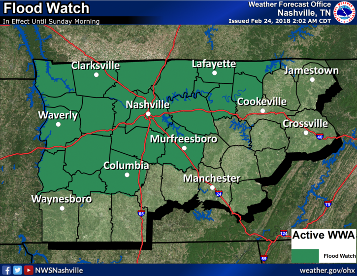
Flood Watch Continues Through Tomorrow Morning

NWS Nashville: A strong low pressure system will sweep through the mid state Saturday night, with additional heavy rainfall expected. Additional rainfall amounts of 1 to 2 inches are forecast during the next 24 hours. This will fall on ground that is largely saturated, and will drain into streams and rivers that are already running high from previous heavy rainfall. Therefore, localized flash flooding and river flooding are possible during and after this next heavy rain event. read more

Severe Weather Possible Saturday Night, Some Dry Days Next Week

Flood Watch In Effect through Saturday Night

NWS Nashville: A Flood Watch continues to be in effect for portions of Middle TN through Saturday night. While most will see a lull in the rain Friday, those in the watch will not. Additional rainfall is expected Saturday, as well. Both localized Flash Flooding and river flooding will be possible by Saturday night. Those who experienced flooding this past week and are in this Flood Watch need to pay special attention to rainfall accumulations as flooding is expected to return to those locations. read more

Flooding Concerns, Heavy Rain; Severe Weather Saturday Night?

Unsettled, Wet Weather Pattern Beginning Today

Rain showers are moving from southwest to northeast through the Mid-State this morning. A surface cold front is slowly meandering through north-central Tennessee, too. Temperatures will be several degrees cooler today, thanks to that and the addition of rainfall. A few thunderstorms are possible through the remainder of the day, but severe weather is not expected. read more

Rain, Rain, Rain For Now. A Break from the Rain Tomorrow

Plenty of Showers Now, Clearing by Tonight

Bands of showers continue to move across much of Middle Tennessee. If you have any plans today, grab the umbrella before you head out the door.

Current Radar as of 11 AM

While we may see periods of heavier downpours, which could lead to some ponding of water in low-lying areas, we are not expecting any flooding issues with these showers. read more

Light Rain, Dropping Temps Today. Soggy Forecast For the Beyond

Temperatures Drop Like a Rock, Mist/Light Rain Rest of Today

The Friday cold front has passed and we are quickly seeing its effects! Temperatures are already down into the middle 40s at 11:00AM, and we are expected to bottom out in the mid to upper 30s overnight tonight. A northwest wind will keep things gusty…20-25mph winds are possible, so keep those loose outdoor items tied down. read more