Latest On Weekend Winter Storm

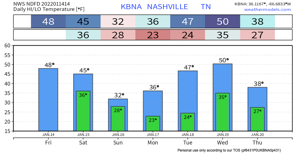
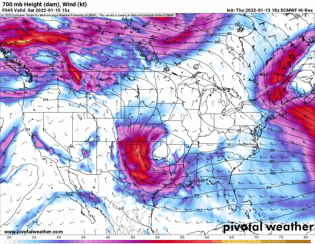
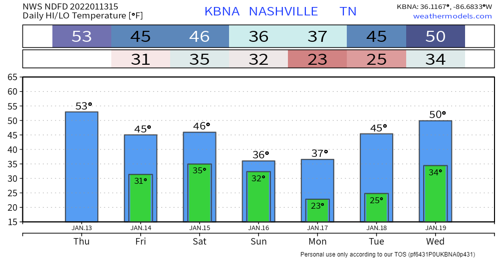
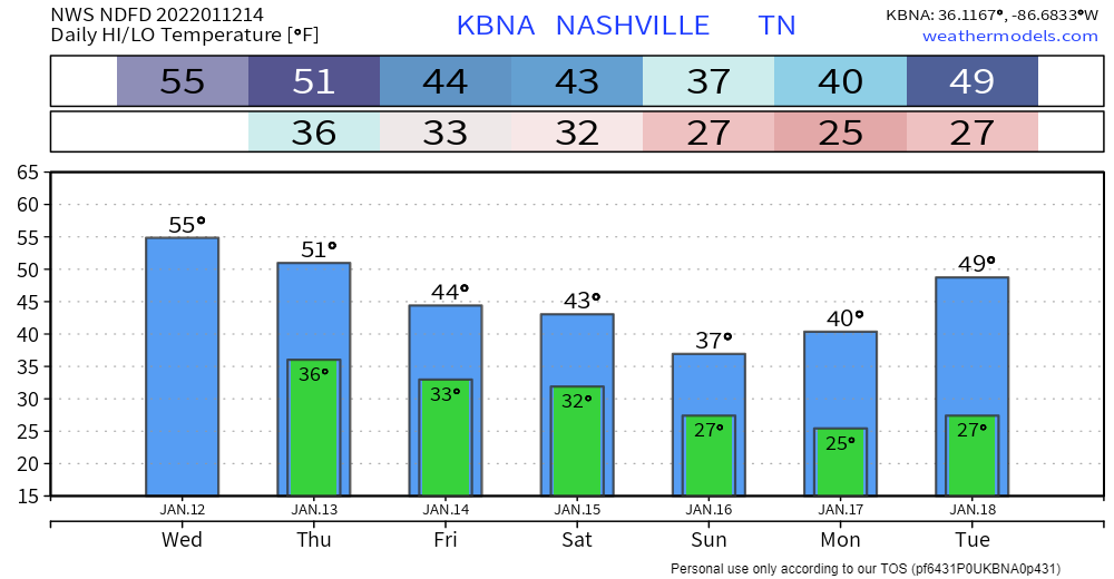
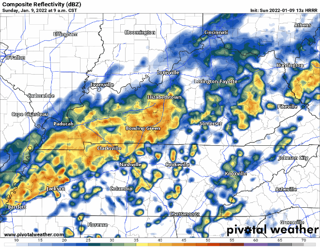
Computer models are lacking consistency. Cold stuff will definitely be falling from the sky but we don’t know exactly what, where or how much. But, we have a forecast. Here we go:

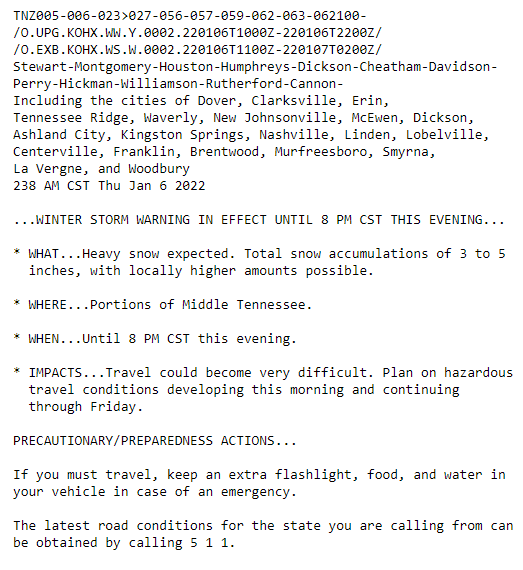
A winter storm watch was issued this morning starting Saturday at 6 pm through Sunday at 6pm. read more

an essay on the “probably a snowstorm” coming our way this weekend

on presnow days like this I spend a few hours looking at models and reading forecast discussions. i do one other thing, and that’s trying to keep my brain brew cold, which means i’ll spend 15 minutes beating up my somehow iced over fridge icemaker, picking up the ice pieces that fall on the floor from all the pounding. i don’t mind admitting to you that when i am beating up the machine i am sometimes definitely cursing at it. the forecast and the ice machine are a mess. read more

Winter Weather Possibilities Remain for This Weekend

Not much change to the forecast for today. More cloud coverage throughout the day plus some scattered sprinklers. Timing: this afternoon. Cooler and dry tomorrow with highs in the mid 40s. Look for wind chills to hang out below 40. read more

Sprinkles Tomorrow (for some); Winter Precip Possible This Weekend

A bit warmer today than yesterday… highs generally 5-10 degrees higher. Staying dry until at least tomorrow.

Overcast skies and maybe rain for some folks tomorrow. Likely just sprinkles; nothing to write home about. A slight cool off starting tomorrow ahead of a possible winter weather event this weekend. read more

Dry Until Possible Showers Thursday; Wintery Mix Saturday into Sunday?

Normal January temps are really sticking. Today and tomorrow will stay dry and cool with overnight lows dancing around the freezing mark.

Our area could see some showers Thursday. Euro model below shows some of us getting sprinkles in the afternoon time. GFS has any precipitation staying clear of our area. If this system lingers and ends up in our area later that night, a flurry may be in the mix. Chances aren’t high, so for now expect some sprinkles. read more

Sunny and Dry Most of the Week

Not much weather going on the next couple days except sunny skies and right around average temperatures. High temps stay in the mid 40’s eventually getting up to the low 50’s by Wednesday and Thursday. read more

Rain Today, Icing Overnight?

HEAVY RAIN

We’re starting off our Sunday with some rain. HRRR model:

We are not expecting anything severe, but you might see some heavier rain or hear some rumbles of thunder as this cold front moves in. The biggest threat? Localized flooding, but this is a low probability hazard. read more

Say Goodbye To Your Snowman, and Hello To Rain

PSA:

Temperatures will climb above 32 degrees at around 10 or 11 AM for the first time in a few days, allowing for some serious melting to begin, aided by the sun. It will take a while for all the ice and snow to melt. Melting occurs at different rates so there may still be slick spots, but today will be a dramatic improvement. read more

Very Cold Today, Rain and Melting Saturday

After yesterday’s record breaking snow, last nights extreme cold, and today’s below freezing temps, you can expect the snow to stick around today. Unless your car has ice skates instead of wheels, AVOID DRIVING IF POSSIBLE!! The roads are still very dangerous and icy. If you absolutely have to drive, make sure to go very slow and leave plenty of room between you and other cars. Don’t make sudden movements. Also be sure to bring extra warm clothes, food and water in case of emergency. read more

Snow is Here + Some COLD Air

Our counties are currently under a Winter Storm Warning (in effect until 8pm tonight). According to the NWS:

Can expect 3 to 5+ inches of accumulation… higher amounts could be seen locally. Let it be known that this is an all snow event. None of the freezing rain/sleet. Seeing pretty quick accumulation from flurries already. read more