

on presnow days like this I spend a few hours looking at models and reading forecast discussions. i do one other thing, and that’s trying to keep my brain brew cold, which means i’ll spend 15 minutes beating up my somehow iced over fridge icemaker, picking up the ice pieces that fall on the floor from all the pounding. i don’t mind admitting to you that when i am beating up the machine i am sometimes definitely cursing at it. the forecast and the ice machine are a mess.
picking up the mess means
- trying to reduce model differences and data contradictions into something coherent (do not worry, somewhere below is an effort to do just that),
- dealing with raw outlier model data seized upon by shock jockeys which means now we have to “respond” to fair questions by reasonable people asking is this legit ?, and
- ignoring uberspecific questions because the answers are only guesses.
can i please say i am glad you are reading this but at the end of the day i don’t really care if you do. i’m not getting a call from a car dealership or roofer or Bread & Food Seller Conglomerate wanting to know about snow blog clicks.
i’m just here to try and be helpful, and if i cannot be helpful, then i can be honest.
the truth here is that this forecast is sober you trying to find out when we gonna stop drinking and all finally go home, only your friends, even the responsible ones, have run up a seven hundred seventeen dollar bar tab. your friend who got into medical school but you never saw her study is for the first time in her life twerking in front of strange hot people, your paleontologist friend back for the week from his tenured university position in zurich who you call indiana has been vomiting booting and rallying since ten am, and the group doofus has just pulled a bathroom chandelier down from a party room and you are already planning his intervention in your head, his hand is bleeding but he says he’s fine, everyone has their head reeling and then you stand up at the bar and ask them to solve a quadratic equation. they all stop and try to answer you.
this snow forecast is what you get.
REALLY, THREE BIG SNOWFALLS IN AHALFAJANUARY?
it’s rare.
ok so yeah, there is one thing the big global models agree on: a storm system will begin west of us, then move south of us, then move east of us. below is the GFS and Euro model at 700 mb, check out the circle thingy, this is pretty good agreement
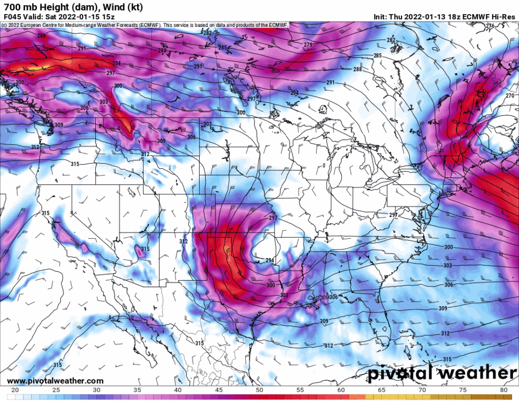
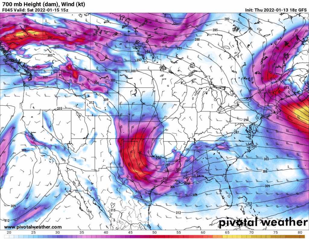
this is the track you want a 700 mb low to take if you want it to bring us snow.
the problem is we aren’t trying to figure out if it’s gonna snow on the northwest side of that storm — because it will — the problem is we are trying to figure out if it’ll snow in davidson or williamson county, and if so, when, and how much, and when will it melt. the problem with that is that the above models are globals, they run at too low a spatial and temporal resolution to figure all that out.
so to say that it’s going to be x inches here and y inches there is asking the models to say what they are not made to say. the good models — the higher resolution models — run about 48 hours into the future, and we’re only tonight just getting close to getting an opinion from those good models. it won’t be until friday that we start to get the higher res information in here to say something helpful and actionable. you may say why am i reading this right now, which is similar to the question i am asking myself: why am i writing this, that’s a question for therapy, for another time.
that said, we do have the nam model, which is often ridiculed and for good reason, but it’s kinda higher resolution (it’s not hrrr, which is beauty), so i’m going to put it down below so you can notice all the switching from rain to snow to sleet to nothing it does, seriously it’s an every flavored snow cone spilling on a freaking tye dyed shirt which are notoriously full of good times but not much for dispensing reliable opinions:
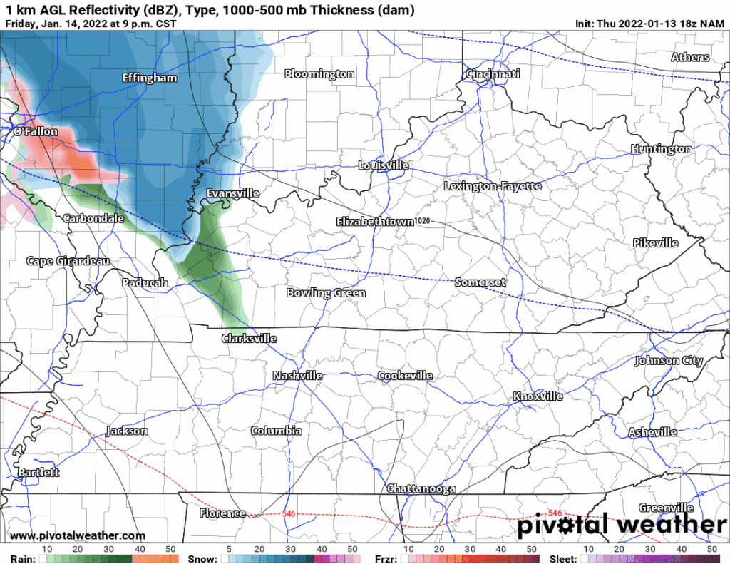
confused? exactly!
nws-nashville knows what they are doing, knows spreading outlier snow accumulation maps across the internet isn’t really helpful. sure we all want answers but not when the answers are probably lies. anyway this is what they came up with and i am thinking of tattooing it to my forehead
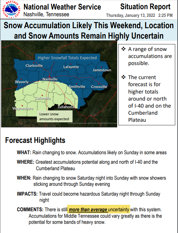
i suppose we could go through all the models but what really would be the point, notice all the consternation dripping out of the nws-nashville forecast disco this afternoon:
The models are still all over the place with no consistency to each other or even to themselves. The NAM low had been moving north to come in line better with the GFS and EURO but not the 12/18Z runs. Was hoping there would be some kind of meeting in the middle for the models…but no luck as of right now. The previous forecast had the heaviest snow over NW Tennessee and along the TN/KY state line. Current forecast now has the heaviest snow over the Plateau. Let/s go with there will be a band of heavier snow somewhere around I-40 and north. Where…your guess is as good as mine. The higher amounts look to be in the 4-6″ range…not some of the crazier high end extreme amounts floating around the internet right now.
if i had to guess at it, based on the data and the 700 mb charts above, look for a cold rain saturday, then saturday night the temp drops and rain changes to sleet then snow. north gets more snow than those south sunday morning, then the system pulls away probably before dark sunday. this could be a sleddable snow and travel harm could befall the city as early as saturday night, and continue through sunday, but i’m not sure some of the snow won’t melt sunday as temps hover around freezing. then we go big freeze sunday night into monday morning and try to melt some of it monday afternoon. but that’s just a guess right now.
so, then, just plan. if you have to travel this weekend, saturday is better than sunday. if planning worship services saturday night or sunday morning, that may be a problem. if you wanna sled, plan on sunday afternoon.
models are showing 18″, 13″, 4.9″, 2.5″, and zero snow, the model spread is comical, the foot and a half model output is only viewable through beer goggles — please, dear reader, please don’t read this as the “range is between nothing a foot and a half.” the message is the models haven’t got a clue.
“There is still more than average uncertainty” (NWS-Nashville) is the only sentence in this blog worthy of a capitalized letter.
tomorrow, better data arrives. not sure we’ll have more answers, but we probably will.
Quick References:
Weather changes constantly.
Follow @NashSevereWx on Twitter for any changes to this forecast.
Live coverage during tornado and severe thunderstorm warnings:
Look good.
Support the mission.
We are 100% community supported. No ads. No subscription fees. Keep it free for everyone.
Categories: Forecast Blogs (Legacy)
You must be logged in to post a comment.