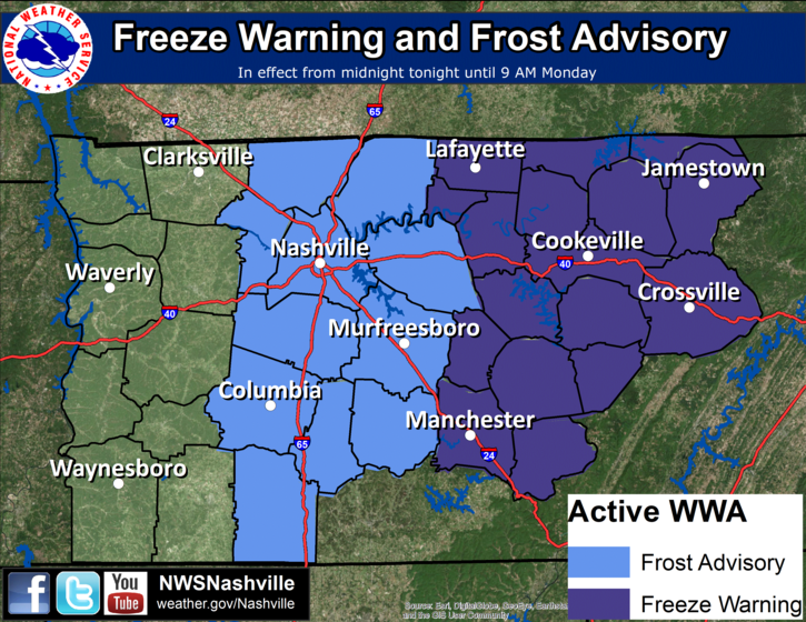
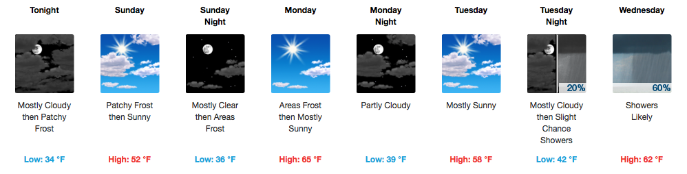
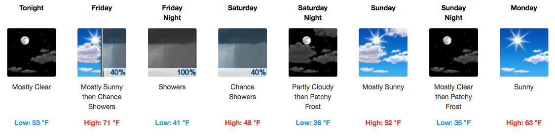
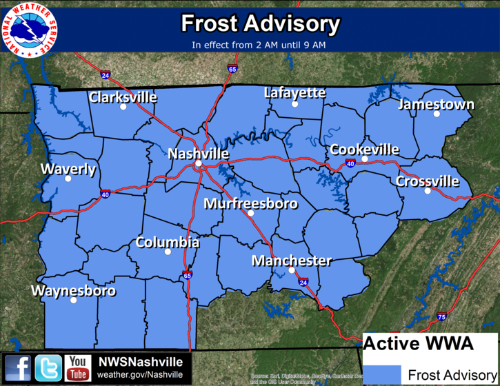
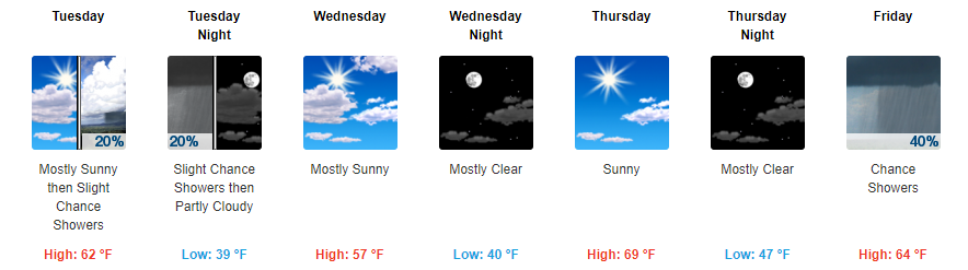
Officially the forecast low overnight is 35° in Nashville and 34° in Franklin. Those with less pavement around you should dip to or close to freezing. Our Frost Advisory is effective at Midnight and runs through 9 AM, technically the coldest temps are expected just before sunrise.
Category: Forecast Blogs (Legacy)
Frost Advisory Tonight
Wood expands and contracts in the summer and winter. With these overnight cold temps, boards in your house “pop” pretty loud, especially in the middle of the night when it’s coldest. It can be so loud you may think someone sinister is inside your house burgling your meat and cheese foodstocks. Do not worry, it’s not a “robber” as is the phrasing at my house, also it’s probably not this guy:
Partly Sunny, Cold, Fluctuating Temps Later This Week
Rain Is Over, Cold Is Not!
GOES 16 Morning Loop
The rain from last night has pushed well east of us and now we are just plain cold. Temperatures are starting around the 40ºF this mid-morning and will only reach into the upper 40s this afternoon. A light northwest breeze will nonchalantly bring in cooler air throughout the day. Wind chills are expected to remain in the lower 40s, dropping below freezing into tomorrow morning.
Showers Arriving, Much Cooler Temps Tomorrow
Warmth Short-Lived, Rain Signals Big Cold This Weekend
Gradual Rise in Temps & Sunshine to Finish the Work Week
Slight Warming Trend Thursday and Friday
Grab a jacket before heading out for any evening plans tonight as temps will fall into the 40s overnight.
Thursday and early Friday appear to be your two best days to get any last minute outdoor yard work done. Highs will top off in the upper 60s to low 70s with plenty of sunshine both days.
Frost Advisory For Morning, Roller Coaster (Mainly Cooler) Temperatures Coming
Hello Fall Temps! Dreary Today, Sunshine Tomorrow
Rain Tonight/Tomorrow No Big Deal; Dispelling Crap App Snow Forecasts Next Weekend
It’s going to rain tonight.
We may see a few light showers beginning around 7-8 PM, but the heavier rain will wait until overnight/early Monday morning.
ETAs may change, so check back here and/or on Twitter with @NashSevereWx for more info. The rain line won’t move east quickly.
Rain Tonight & Tomorrow, a PSA, a Peek at Trick-or-Treat Temps
Expect a breezy/windy Sunday afternoon. Gusts in the 20 MPH range are possible. It’ll be overcast, high 79°, with the return of late summertime humidity.
Rain will be here late tonight.
Last night we thought it would be here around 7 PM, but models overnight have pushed the ETA back. Expect rain to start well after dark, as a slow, light rain gradually increasing through the night.