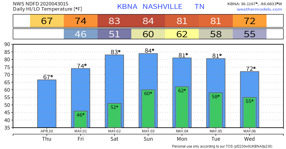
Sunshine!

Lots of sun today. Weโ€™ve hit 73ยฐ in my back yard and 75ยฐ at BNA. These clear skies and warm temps continue. Tomorrow, the 80โ€™s return.

Beyond Saturday

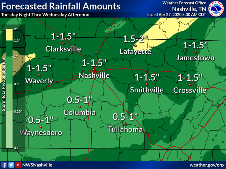
The blue skies and sun continue through Sunday morning. Clouds begin moving in around lunch and by sundown Sunday night begins our chance for rain and storms. read more

Clear Sailing for the Foreseeable Future.

Excellent next 4 days.

Rain today will be east of us.

It won’t rain here until late Sunday night into Monday.

Sweaty humidity Sunday and Monday.

Severe weather Monday? Nah. Probably just rain.

Look for off and on rain Monday through Wednesday. Very little each day. read more

Rain & Storms Today. Also Late Sunday.

Rain and storms are expected around lunch into early afternoon.

HRRR model thinks it’ll arrive between 1 PM and 2 PM.

Lightning is possible but unlikely. About 0.2″ or less expected:

These storms will feed off a narrow strip of storm fuel. But — severe weather is not expected. read more

Mid-Week Rain and Storms. Weekend Looking Decent

Remainder of the Afternoon

A mix of sun and clouds, and a temperature around 78ยฐ. No rain in the forecast until later tonight.

Our Mid-Week Storm System

Rain chances will be with us beginning tonight and will close sometime Thursday. To our west, we will be watching a pretty stout line of storms push our direction. We think this line of storms will be weakening as it approaches. read more

Excellent Weather Until Tuesday Night, Rain Midweek

Remainder of the Afternoon

Sunshine and 72ยฐ as of 4:00 pm. This has been a fantastic day.

Tuesday will be similar, a bit warmer, with highs around 77ยฐ.

The Next Storm System

Tuesday night, our next system will swing in bringing a chance for rain and thunderstorms. The window for rain opens Tuesday late afternoon and closes Thursday morning. read more

Light Afternoon Rain - We Done Freezing? - Heavier Rain Late Tue Into Wed - Remembering 10 Years Ago Next Weekend.

Yesterday’s Wilson/Smith Co. Tornado.

Just before 4:45 PM, the line that came through north Williamson County/south Davidson County tapped higher instability and slightly more favorable tornadomaking ingredients. read more

Off and On Rain and Storms

Today we’ll see waves or rain, and possibly some strong to severe storms. read more

Sun Today, Chance of Storms Tomorrow

Today will be around 72ยบ with plenty of mid-day sun.

Storms and Rain on Saturday and Sunday?

Low pressure moves from west to east Saturday. Showers may start as early as midnight tonight, and will get wider in coverage through the morning. Strongest winds will be around mid-day and stick around through Sunday. read more

Windy; Scattered Storms This Afternoon, Low-Probability Tornado Risk

A surface low is passing by, strengthening winds. Expect 40 MPH wind gusts this morning, afternoon, and early evening, then relaxing later tonight.

Something is up.

That something is rain and storms breaking out just after lunch, then scattering and moving east through the afternoon, ending just before midnight. Like this: read more

Three Rain Events, May Contain Storms, No Current Worries.

Rain & Wind Event Tonight/Thursday

A brief shower possible early tonight (Wednesday).

The real rain event begins around midnight. Here it is from midnight to 5 AM Thursday:

NWS-Nashville thinks more than a half inch of rain. Storms are possible with shear off the charts (again) but zero instability (again) so no tornado or hail concerns. read more