Wring Out the Water on New Year’s Eve

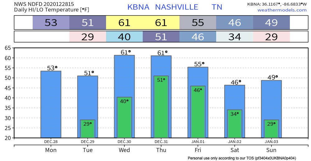
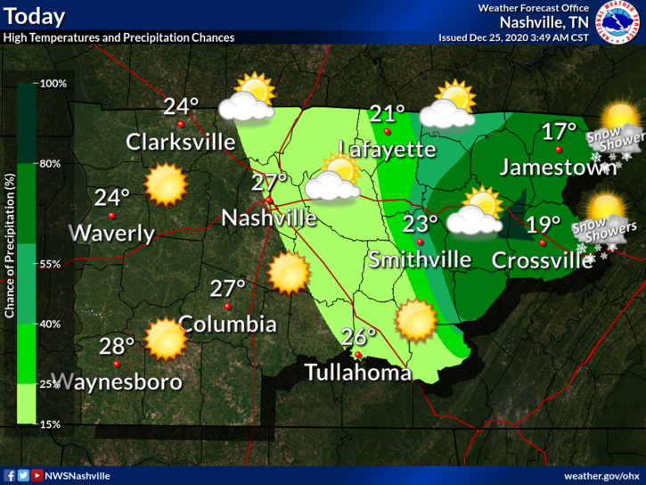
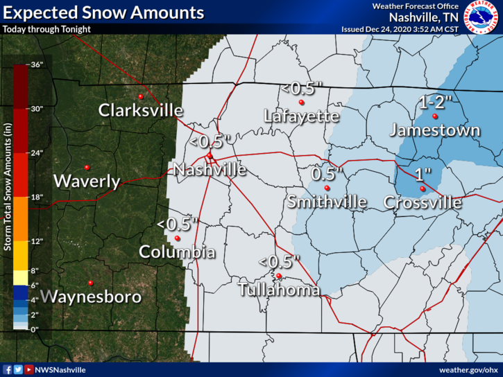
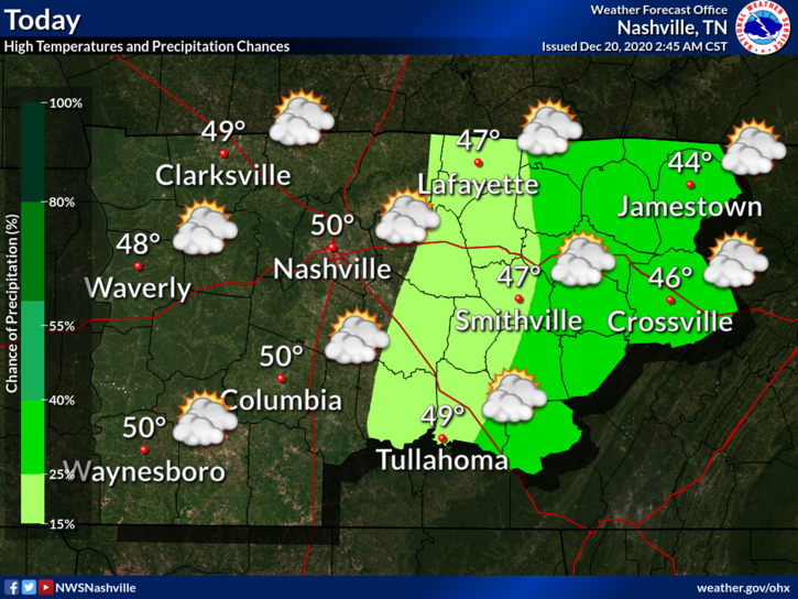
Clouds and sun next couple of days. Unseasonably warm for winter.

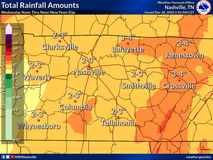
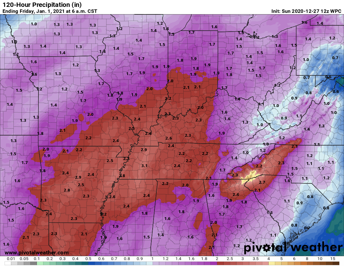
Heavy Rain Event Incoming for New Years Eve/Day

Heavy rain will spill out of a robust weather system that’ll pass to our west Wednesday and Thursday. Northwest of the low (the big red L below), snow. We’ll be southeast of the low, so rain. read more

Wet New Year’s Eve.

2020 began with heavy rain. 2020 will end with heavy rain.

First, a minor event tonight.

Light rain tonight, ETA a few hours before midnight. Not a heavy event (that’s Thursday). Tonight’s rain will be off and on, scattered, and should end around sunrise Monday. Was hardly worth mentioning but here it is. HRRR model below. read more

Warming Trend Through the Weekend, A Look at the System Coming Wednesday

It was definitely a chilly morning when some of you woke up:

We have sunny skies and temps warming up through the afternoon, highs around 48°.

The Great Flocking of 2020

Christmas Day 2019 we touched 70°.

Christmas Day 2020…

Yikes

Currently 20° with a wind chill of 7°. Remember to look after those furry friends, check in on the elderly/those without heat, and the pipes. read more

We Discuss the C.O.L.D. (Chance Of Light Dusting)

Flurries Possible This Afternoon

What’s on everybody’s mind, perhaps more than what’s under the Christmas tree.

Model soundings for this afternoon show a very shallow layer of moisture. There is enough lift in the atmosphere to squeeze out a few flakes for us. Our best chances of seeing the white stuff will be after about 3pm. read more

Happy Festivus Everybody! Updates on Wind, Rain, Snow, Flurries, Cold. Y’all. The Cold!

Oh, no, Sir. Festivus is all too real.

George Costanza

Wind

37 MPH was the top reported hourly BNA wind gust as of 6 PM. Gusts 40-45 MPH are possible until midnight. A Wind Advisory remains in effect until then. Winds will blow from the south. read more

Windy Today and Rainy Tonight, Possible Christmas Eve Dusting, Frigid Temps Christmas Eve and Christmas Day

Some rain and gusty winds are in store for us today into tonight as a cold front moves eastward across Tennessee.

Any outdoor holiday decorations that aren’t secured down could end up in the neighbor’s yard with wind gusts to 35 mph. read more

Rain Begins Late Wednesday, Will It End With A Little Snow Thursday Morning?

Nothing much to talk about today: clear skies, plenty of sunshine, and high temps near 55°.

Clouds will begin to move in overnight.

Rain Wednesday Night into Thursday

Wake up to around 38°. Afternoon highs in the lower 60°s .

Through the afternoon, a shower or two could roll into your neighborhood ahead of the main line. Golfers should expect wind gusts to 28 MPH. Protect feeble inflatable Santas. read more

Christmas Star Tonight (yes). Rain Wednesday Night - Thursday (yes). White Christmas (not really, no. kinda? maybe?).

The first official day of winter began this morning at 4:02 AM, meaning today marks the least amount of daylight of the year (and the longest amount of darkness of the year.)

Happy First Day of Winter! Now where's the snow? | Hello winter, Welcome  winter, Winter images

Winter temps will wait until Christmas Day. read more

I’m dreaming . . . of a flocked, Christmas. Just like the ones at Home Depot.

Overnight rain has moved out and we are left socked in with clouds. Good news is that we do start the warming trend today. Should top out around 50 today.

And it’s only going to get warmer from here… read more