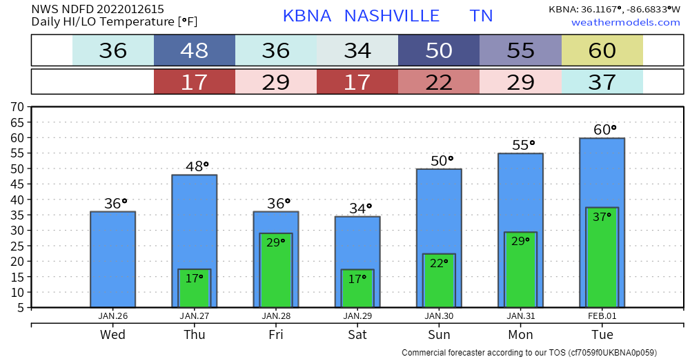
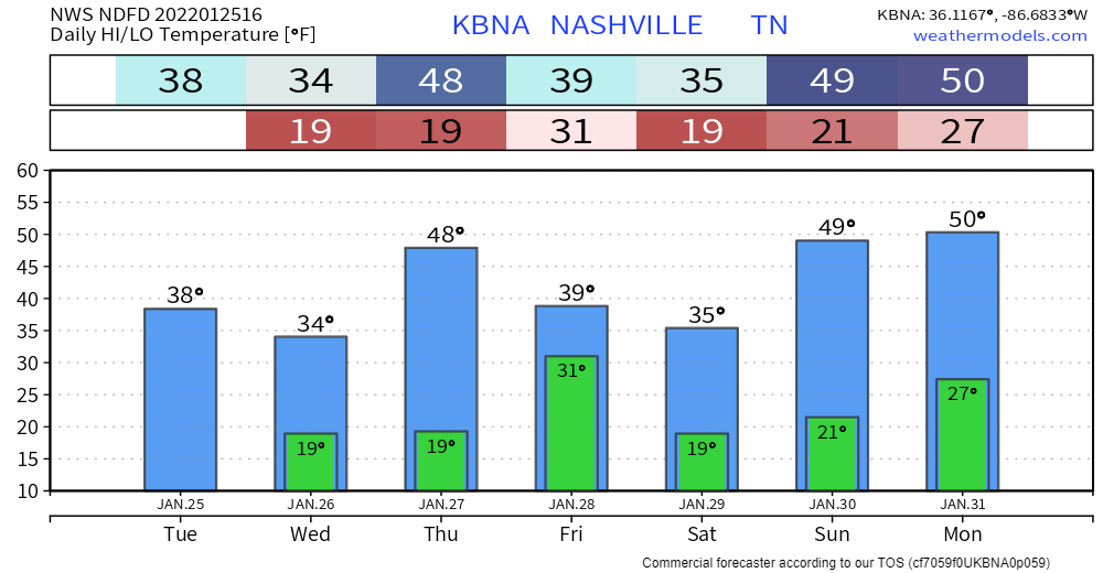
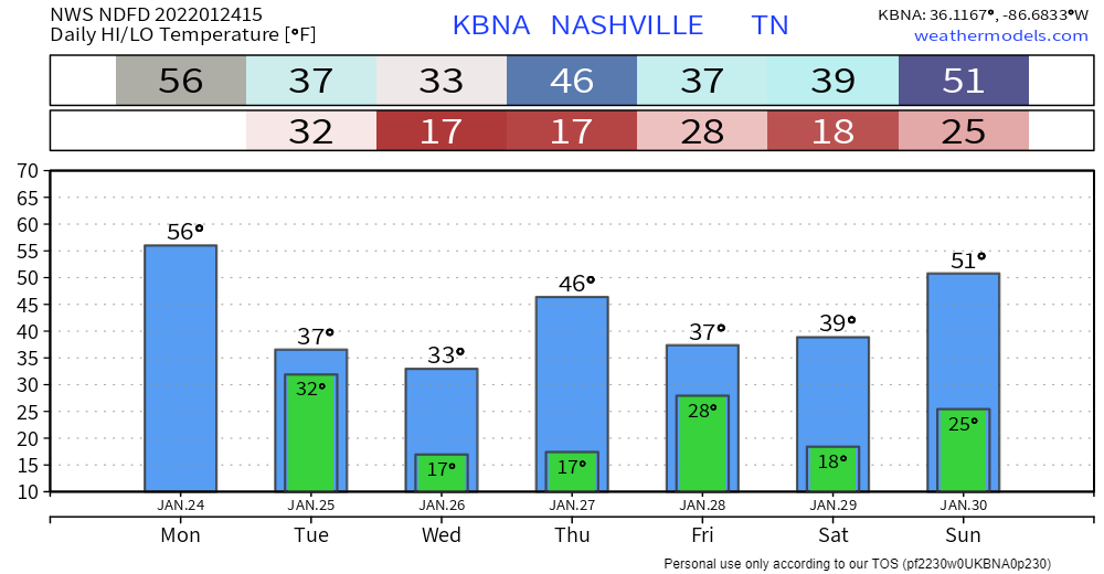
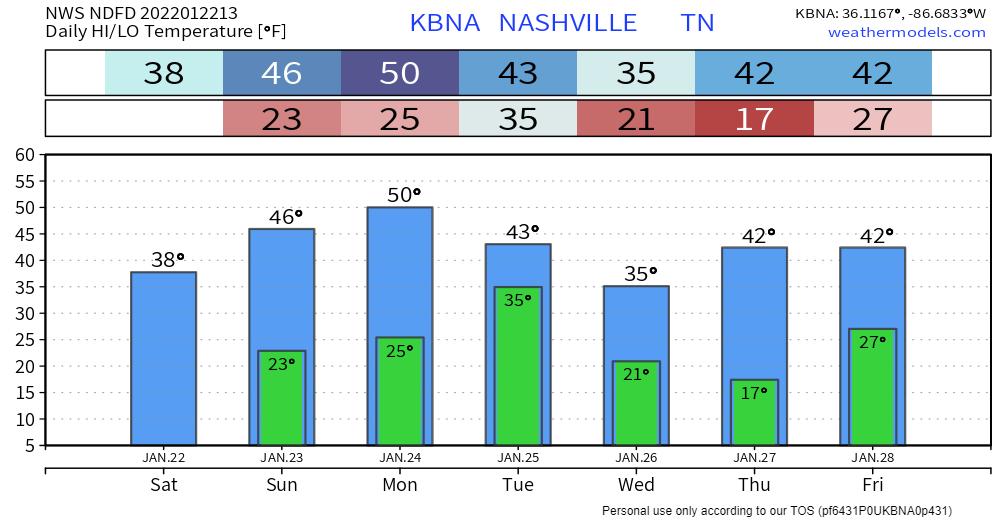
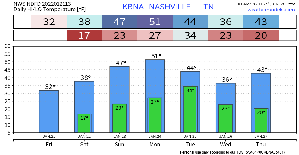
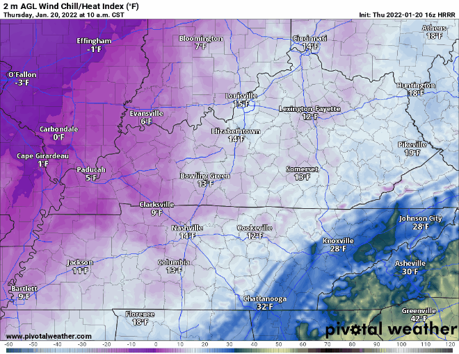
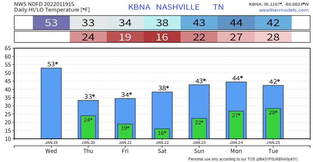
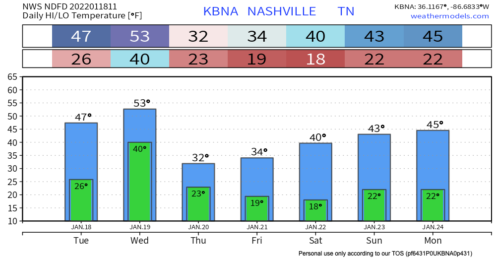
Sunny and 70s!

The rain and storms have made their way to our East, and what’s left is some mild temperatures and low dewpoints.

How long will it last?

Two days. The surface high that’s providing these awesome temps will be here through Wednesday, but then a low pressure system moves in to raise humidity into extra deodorant swipe/hair probs levels. read more

Storms Today: Hazards, Timing

A cold front moving east will collide with our humid airmass to bring activity delaying lightning, heavy rain in some spots, and — potentially — damaging straight line winds.

What to Expect:

We do not expect tornadoes. We’re excluded from SPC tornado outlooks and NWS-Nashville forecasts and graphics. This is because forecast data (see below) does not indicate a tornado-hospitable atmosphere as storms arrive. read more

Dry Father’s Day; Front Brings Rain, Storms, Maybe Rainouts Monday

We Gift You No Rain for Father’s Day

Today is going to be hot and humid. Dewps will hover in the upper 60’s. Thank Claudette-related tropical air for all the moisture in our area.

We aren’t getting Claudette’s rain, tho. Claudette never intended to visit Tennessee. It’s speeding away. read more

Muggy + Hot This Weekend; Rain (Storms?) Likely Monday

Typical summertime heat and humidity this weekend, with dewpoints in the upper 60’s, even creeping up into the low 70’s on Sunday and Monday. That’s a lot of humidity, common for this time of year. read more

Hot and Humid; Potential for Rain Sunday

Summertime heat and humidity has returned. Temps will climb into the 90’s as the day goes on. Dewps are also on the rise. Values in the mid 60’s for today. Hot and muggy. (At least it’s dry!) read more

Heating Up + Rain Possible Sunday

Temperatures start rising today with highs reaching the low 90’s up until Saturday. Dew points also rise to the upper 60’s by the end of the week. Ugh weren’t we enjoying that humidity break?! Rain chances begin to gradually increase as does the heat. read more

Nice and Dry... For Now

The cold front that passed through yesterday has left us some dry and cool air, which continues until the weekend.

Friday, the cold front that brought us this cool and dry weather will have moved well off the east coast. Two things will happen after this. 1, we will warm up significantly (dewpoints and temperatures). 2, we’ll be watching the Gulf Coast to see when/if a tropical system will make landfall. read more

Dry and Cooling Down Woohoo!!

The cold front that caused that photogenic thunderstorm to our SE on Sunday has finally delivered the goods. Super dry air! See the deep oranges on the water vapor loop below, that’s the stuff:

No rain, mid 80’s this afternoon, with dewpoints in the 50’s, yes please: read more

Outdoor Plans are a Go This Week

Rain will not ruin the family wiffleball game.

Editor’s Note: family wiffleball games?

Plan on clear skies and dry conditions for the coming days. HRRR is showing little to no cloud coverage for the day. read more

A Cold Front? But It’s 90 outside!

Temps up into the 90s this afternoon. Heat index is expected 99 degrees. Dewps in the low to mid 70s are oppressive according to the scale below.

Most of the morning and afternoon will be free of rain. If you’re thinking it’s about time, don’t get too ahead of yourself. Scattered thunderstorms are STILL a possibility with a cold front passing through the area late this afternoon. read more