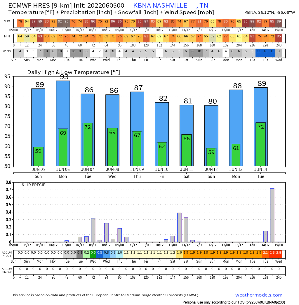
If you like the heat, lower than seasonal dew points, and lots of sun, then buddy, today is your day.
I have a close friend named Fulton, we love to fish together, although we don’t do it often enough. If there was ever a day to go fishing with a friend of yours, then buddy, today is your day. Here’s a limit of walleye from Minnesota we caught in 2016. read more
Happy Friday! Today looks like a great weather day with only a slight chance of passing showers. An overnight front showed up and is doing its best to limit dew points to below 60º. It’s hard work, but so far we’re winning the fight against the moisture. read more
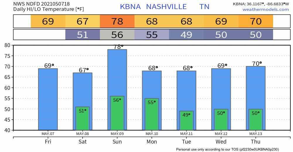
When I started looking at data to write this blog I was hoping I’d see a gradual cool down and a return to more spring like temps.
The we’ll see 90º today and upper 80s on Friday with 60º dew points for the entire forecast period. That’s a recipe for hot and sticky feels when outside. read more
Last night almost all of us saw gusty winds and heavy rain. We were fortunate severe weather mostly avoided our two counties. However, those winds were legit.
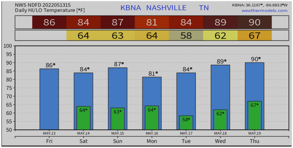
For many of you, this is what you’ve been waiting for. Lowes low enough to make you bundle up. NWS Nashville noted a 15° temp drop. Today, highs that let you wear that sweater. Cue the gif…
For the next several days, we’ll gradually warm, but barely over 75°. Lows in the evenings will round up to about 50°. Locally colder lows are possible. read more
First of all… I hate the typical clip art on weather sites/apps, but I’m going to show it now because I think it give us a clue as to what to expect for the next few days.
Rain
May is our wettest month, so it’s no surprise that we’ll see plenty of water in the coming days. read more
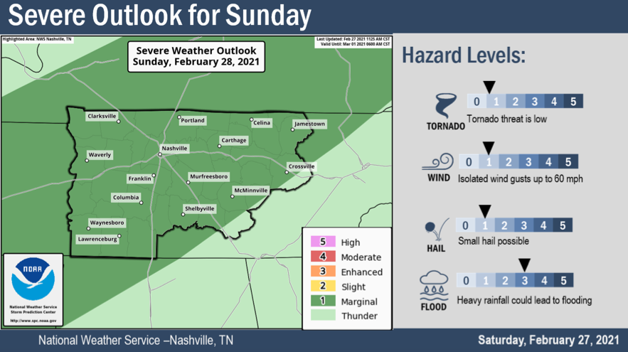
The Storm Prediction Center in Norman, OK has given us a Slight Risk for Sunday afternoon, but we don’t expect widespread severe weather.
Sunday
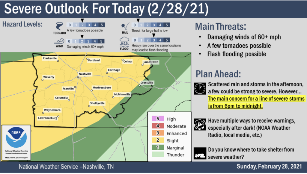
As mentioned above, spc put us in a slight risk for Sunday. The main concerns are flooding, and a non-zero chance of brief Tornados, damaging wind, and small hail. This isn’t some widespread severe weather event, but it has us interested enough to write a special blog to discuss it. So let’s dig in.
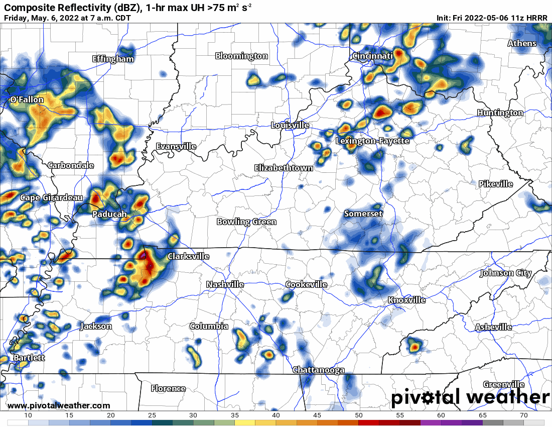
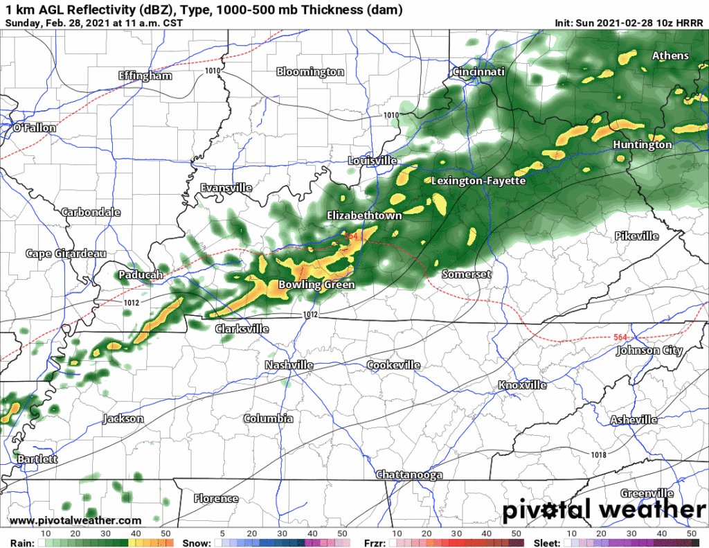
10z HRRR Reflectivity Loop
Above, the HRRR model is running through Sunday night. A storm complex riding a cool front comes our way Sunday afternoon. Exact timing is still a little unsteady, but we think it will be Sunday evening for the “main event”.
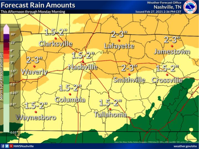
We know it will bring us lots of rain.
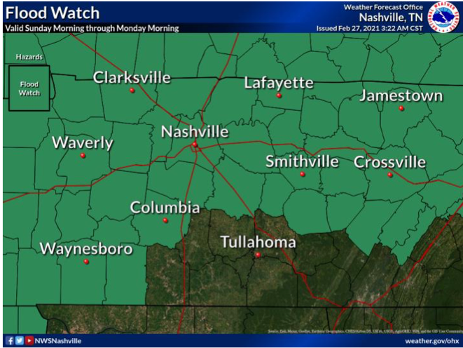
The above graphic is showing a forecasted amount of multiple inches, and that has triggered a flood watch through Monday morning. Creeks, rivers, drainage ditches will remain full and may exceed flood guidance, triggering flood warnings tomorrow night. An isolated 4″ of rain for some us is not out of the question. Flash flooding will be of most concern in areas that receive a lot of rain yesterday. Creek and river levels can be checked here… NashSevereWX Flood Resources
A flood advisory will like remain in effect through 6pm Wednesday.
Severe Threat
It’s low. But it’s not zero and the greater threat exists if there isn’t a cloud deck in place tomorrow afternoon. The setup Sunday is going to be influenced by storm fuel (heat + instability).
Here’s what the NWS said in their Saturday afternoon AFD…
Afternoon
high temps on Sunday expected to sore into mid 70s south with a
good amount of instability and favorable lapses rates for strong
to severe convection development, especially if rainfall does not
move into this portion of mid state region until late afternoon
hours allowing for increased atmospheric instability due to
enhanced diurnal heating influences.read more
Privacy & Cookies: This site uses cookies. By continuing to use this website, you agree to their use.
To find out more, including how to control cookies, see here:
Privacy Policy


You must be logged in to post a comment.