Warmer, More Humidity This Week

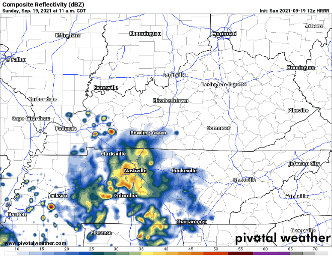
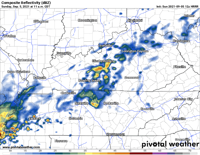
Fog is mixing out this morning. It was pretty bad in spots.

No controversy about rain today. Perfect for Titans football.
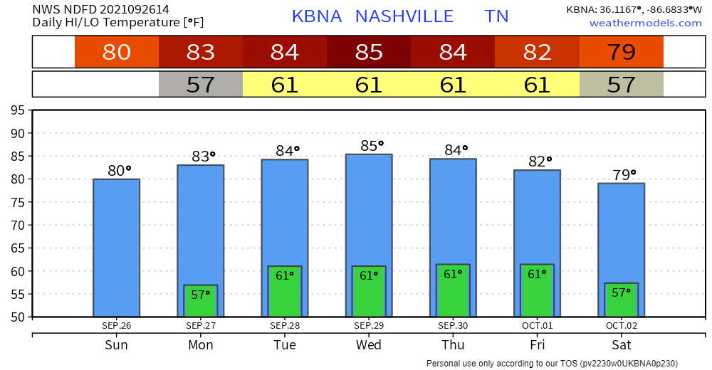
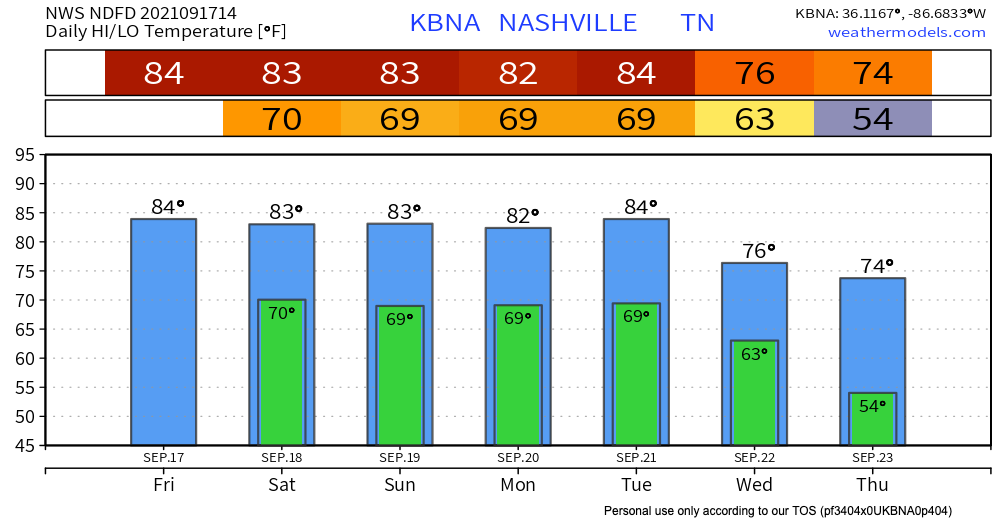
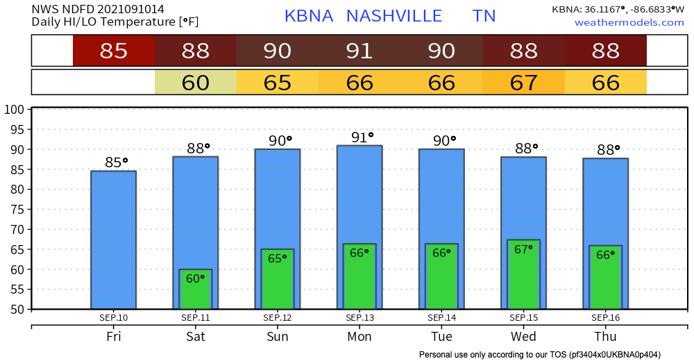
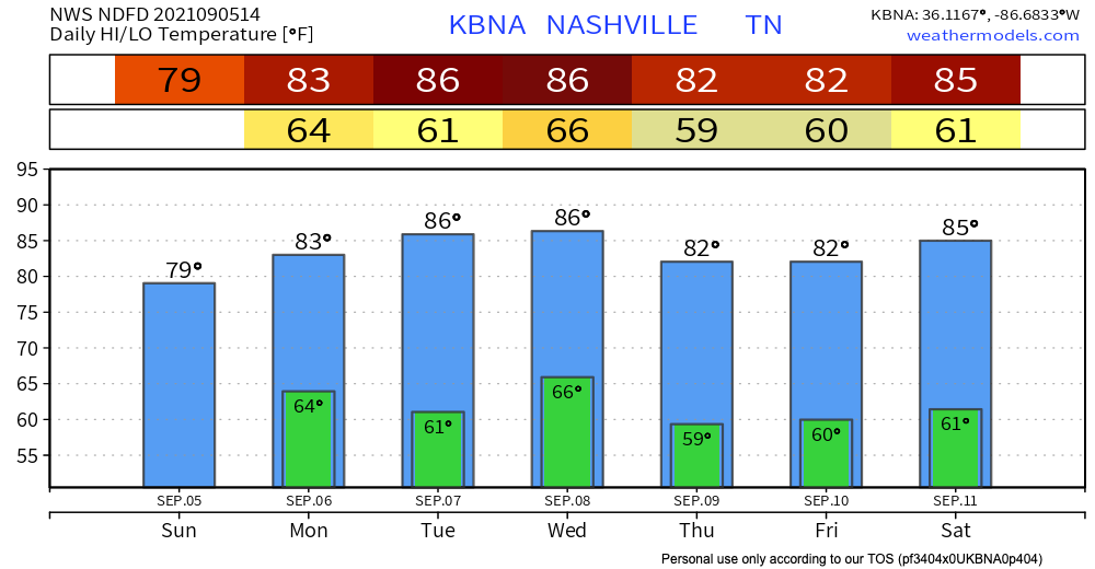
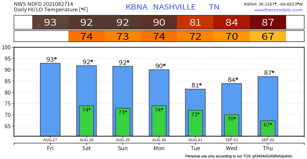
Tennessee Titans GIFs | Tenor

Humidity Returns

Dewpoints will climb into the 60s Monday afternoon and stay there for most of the week. That means more humidity and less of that fall time feel.

Humidity comes back down Friday after a weak front paves the way for it late Wednesday. The weekend should be less humid and more comfortable than the work/school week.

Temps this week above normal.

Editor’s Note:

Success! #PSLgross

Next Weather Change (or not?)

Models debate whether we will get a little rain late this week from that weak front. The yes-we-think-it’ll-rain model is the GFS which is not trustworthy, and the Euro is dry, so NWS-Nashville decided to keep the forecast dry for now. If it does rain, look for very little of it. No rainouts forecast.

Generally speaking the first third of October looks warmer and drier than normal:

8 to 14 Day Outlook - Temperature Probability
8 to 14 Day Outlook - Precipitation Probability

Flash Flood Watch Through Monday; Fall Weather Approaching

Rain will continue today. HRRR shows our area getting rain from lunchtime to the evening.

These showers and storms can drop a lot of water fast which is why were under a Flash Flood Watch through Monday night. WPC has us in the 10-20% chance of a flash flood occurring. Be alert, don’t drive through flooded roads.

It’ll take about 1.5″ per hour in Nashville, 2″ per hour in Will Co, to get the flash flooding going. If we can avoid those rainfall rates, we should be OK.

Nothing severe expected with these like bad winds, hail, or tornadoes. Some lightning is possible but this is expected to be a primarily a rain event.

Flash Flood Watch Continues Monday

The waterworks continue into Monday, and so does the Flash Flood Watch for our area. HRRR shows showers and storms from early morning all the way through the evening.

WPC still thinks there is a chance for flash flooding Monday, just a lower one at a 5-10% chance. Even though it seems like a low chance, it shouldn’t be shrugged off. All it takes is one line of storms to “train” over your area, or just dumping a lot of rain into the creeks and streams that’ll fill up and flow through your area and route.

Rainfall totals vary. Some datasets half an inch to an inch. Southern Williamson county could get 1.5-2 inches. See image below:

Other model data thinks 1″ to 2″. Exact locations, timings, and impacts are unknown, so please don’t tweet us “what about my thing at this time,” because to answer that would be irresponsible.

Fall is on the way

A cold front moving through Tuesday night and Wednesday should bring around another inch or so of rain Tuesday. See below.

A heroic cold front will sweep across Wednesday. You’ll feel humidity drop Wednesday night. Thursday morning you’ll probably want a jacket. The end of the week (for now) looks glorious.

Autumn GIFs - Get the best GIF on GIPHY

Rain Continues Today; Wet Weekend Ahead

Scattered showers and storms continue today, and coverage looks much more widespread. Storms start firing up around lunchtime and hang around into the overnight hours. Nothing severe expected, but lots of lightning, thunder, and downpours can happen with these. The potential for rain/lightning delays to anything outdoors exists. Radar will definitely be handy today.

Rain, rain go away?

The rain is not going anywhere.

Im Not Leaving GIFs | Tenor

Showers and storms pick back up early Saturday morning, way before most of us wake up. They hang around all day, and finally clear up in the evening. Saturday looks more like a washout rather than the typical hit or miss storms. Like Friday, nothing severe is expected, but lightning and heavy rain is expected. See HRRR below:

Temps in the 80’s combined with dewps in the low 70’s will make this weekend pretty muggy. Hair = ruined.

Showers and storms are here for the whole weekend, so expect a wet Sunday, too. Our next chance at a dry day looks like Wednesday or Thursday next week. We’ll keep you posted!

Dry Weather Continues; Temperatures Rising Through Next Week

Sun today and temps in the low 80s. Dewpoint should hang out in the upper 50’s, so no need to worry about feeling sticky. Thank you surface high pressure.

HRRR shows nothing in terms of rain, all outdoor weekend plans are safe.

Safe GIF - Safe Umpire Baseball - Discover & Share GIFs

Temps increase into Saturday. They increase again heading into Sunday. They peak around the low 90’s Sunday & Monday, so nothing crazy. Dewpoints also increase as we head into the weekend, climbing into the low 60’s.

We’re probably looking at the best weekend for outdoor plans in a while. Those attending the Titan’s home opener can rejoice.

Derrick Henry Stiff Arm GIFs - Get the best GIF on GIPHY

Next Rain Chance

Rain holds off until Tuesday or Wednesday as high pressure breaks down and allows for a cool front to come through. More on this as we get into next week.

Rainy Sunday; Dry Labor Day & Week Ahead

A big blob of bleh moved into our area this morning. Lingering rain moves through our area the rest of the day. Nothing severe. See HRRR below:

Rain becomes way more patchy after the initial round this morning. Some areas will get more rain than others. Looks like things should clear up around 6, so anything outdoors in the evening shouldn’t be at risk of rain.

Other news today besides the rain are the temperatures, which are cooooooool. The high doesn’t look like it’ll break 80.

Whats Cooler Than Being Cool GIFs - Get the best GIF on GIPHY

Dewpoints are in the upper 60’s so don’t plan on having the best hair day.

Rain staying or leaving for Labor Day?

The rain will not be hanging around for Labor Day. Forecast looks fantastic for the holiday. Temps will be in the low 80’s and dewps will hover right around the 60 mark. Translation: Comfortable.

No rain means outdoor plans are a go. Barbecues and lake days commence.

Bbq GIFs | Tenor

Rest of the Week Looks Dry

Not expecting rain for our area through Saturday. The forecast can always change, but that isn’t looking likely. We’ll keep you posted this week.

Drier and Cooler Pattern Continues Through Saturday; Next Chance of Rain Sunday

“Low humidity and mild temperatures will make today and Friday fantastic”.

Words straight from the NWS.

Best Day Ever GIFs | Tenor

Alright, now let’s talk about why Thursday is looking so fantastic. High temps will be in the low 80’s & dewpoints will be in the high 50’s. Talk about a comfortable day. Ida took all the moisture with it I guess, and we are not complaining.

Temps begin to ever so slightly climb Friday and into the weekend. Nothing terrible though. Highs will hover in the mid 80’s. Dewps start to climb back into the low 60’s. It’ll feel a bit sticky, but again nothing terrible.

Rest of the weekend dry?

Next shot at rain looks like Sunday courtesy of a front skirting by us. It will bring scattered showers and storms, but nothing severe is anticipated. There is a chance that showers could creep into our area Saturday night, but I wouldn’t count on it.

A lot can change by Sunday, and model confidence will increase as we get closer to the weekend. More on this soon!

Low Chance for Rain Today and Tomorrow; Ida Impacts Next Week

Woo you made it to Friday! Now let’s talk weather.

Friday for the most part is looking sunny. Temps in the low-mid 90’s coupled with dewpoints in the low 70’s will make it feel pretty hot and humid. Deodorant is our friend.

Deodorant GIFs | Tenor

Rain probabilities are low today. HRRR is showing storms pop-up in the afternoon/evening. The overall coverage of the storms are low, so there is a real shot none hit our area.

If for some unfortunate reason your outdoor plans get caught in one of these storms, it should be brief. Lightning is definitely possible with these, so keep an eye out. Storms should subside around sunset.

Copy and paste weather today for tomorrow

Saturday looks unbelievably similar to Friday weather wise. Similar high temp, similar dewps, similar heat and humidty.

Rain chances are low again. Same deal as Friday, low coverage afternoon/evening storms. Hit or miss kind we all have grown so used to.

What the heck is Ida?

You’re probably going to be hearing that name a lot more over the weekend and into next week.

Ida is a tropical storm in the Caribbean right now. It’ll keep moving into the Gulf over the weekend. Ida is forecasted to potentially impact our area. If Ida does indeed take a trip to Williamson & Davidson Co., it will be much weaker than it will be in the Gulf. Probably a tropical depression.

Let’s all gather ’round and take a look at the cone of uncertainty:

Image

Around 2 AM on Wednesday, the cone shows the remnants of Ida could be at our doorstep, they also could be in Arkansas or Georgia. That is why it is called the cone of uncertainty. Model confidence decreases further out in time, so the potential path of the storm widens. As we get closer to the next week, the cone will shrink and we’ll have a much better idea on the path Ida’s taking. Maybe don’t mention the cone of uncertainty around your dog at home… they might get the wrong idea.

Cone Of Shame GIFs - Get the best GIF on GIPHY

More on Ida from us as we get closer to next week!

Wet Weekend Ahead; Drier and Warmer Pattern For Next Week

Scattered storms from last night have lingered around and are still in our area this morning. HRRR has these storms hanging around most of the day. No severe weather is expected with these. Main concern is lightning and gusty winds.

The HRRR is not perfect, so the locations of where you are seeing these storms pop-up in the gif probably won’t be exactly where they happen. These are the classic “Why are my outdoor plans getting rained on but not my friend’s 5 miles away?” type of storms. Your outdoor plans could be totally fine, they also could NOT be totally fine. A lightning plan is advised if you’re going to be outside.

Our area is right near the edge of where the WPC gives a 5-10% chance for flash flooding to occur. See below:

Day 1 Excessive Rainfall Forecast

Some of these storms can pour buckets, but since they are so scattered the risk of flash flooding is lower. The risk for Davidson and Williamson Co. is low but not zero. Take the advice of the friendly man below if you encounter a road that looks suspiciously underwater.

Turn Around, Don't Drown PSA Music Video featuring Matt Hawk - YouTube

Saturday is Friday but more rain

HRRR is showing 2 rounds of rain for our area. The first looks like it gets to us in the early morning hours. Like really early, 4am-ish. This precipitation looks more organized than scattered, so I’d plan for it. HRRR shows the heaviest just to our west. If the storms move a little more east, it will rain a lot more.

No severe threat expected with these storms. Same concerns as Friday, lightning and gusty winds. Same flash flood guidance as Friday. Only thing different is a loud clap of thunder may wake you at 4 AM. Rain should end after lunch time.

Monica gellar GIF - Find on GIFER

Next round of Saturday storms picks up in the evening. This time the storms look much more widespread, but the HRRR has them tracking right over us. Could be wrong, but have a plan for them.

Closing out the weekend

Rain probabilities are lower on Sunday compared to Friday & Saturday. Euro shows scattered showers and storms until Sunday evening. After this rain, we transition to warmer and drier weather. The lower than average temps we had will start to climb as we head into next week.

Heat Advisory Continues Today; “Cooler” Temps Ahead

A heat advisory is still in effect for our area today 11 AM – 8 PM CDT. This portion of the blog will read similar to yesterday’s, but heat safety is important.

Heat indicies from 100 to 110 degrees are possible today. The past couple days have been miserable, we know. The NWS says today will be the “miserablest”. If you have to be outside in this heat, staying hydrated, shade, and air conditioning are key. A great graphic was included in yesterday’s blog about signs of heat exhaustion and heat stroke. It is included again below if you didn’t have the chance to glance over it.

Know the signs of heat exhaustion, heat stroke and how to prevent them  during hot summer months | WFXRtv

It’s hard to focus on other things than the absurd heat right now, but let’s try. Dewpoints will hover around the low 70’s today. This moisture and heat combo will make it feel like you’re in a sauna.

Rain probabilities today are low. The HRRR thinks our area stays dry, but rain is still possible with all of this heat and moisture in the air. Model shows the precip occurring well to our east so I would’t worry too much. If we do get a shower it will be quick and painless, unlike the heat.

Can we get a break from the heat?

Yes! A ~relative~ break from the heat. Friday typically would’t be classified as a “cool” day, but compared to today, we’ll take it. Highs will be in the mid 90’s and dewps will be in the low 70’s. Not the ideal day, but an improvement from today.

A more noticeable drop in temperature will happen Saturday after a cold front marches through our area Saturday morning. Temperatures will drop from apocalyptic to typical Nashville summer starting Saturday. See the top image for a sneak peek of what’s to come.

Will this front bring rain?

Yup. HRRR shows our area getting hit with 2 rounds of showers and storms on Friday. The first around early afternoon, and the second around the evening.

Round 1:

Round 2:

Thunderstorm coverage is pretty widespread, but they shouldn’t be severe. Lightning and heavy rain are definitely possible with these, and could cause problems for outdoor activities.

Saturday looks pretty similar to Friday. Sunday looks like our best shot at dry weather this weekend. We’ll have more weekend updates tomorrow!

Heat & Humidity Increase

Hot and humid again today. Dewpoints hover in the upper 60°s today.

Rain should probably not be an issue today. HRRR shows nothing in our area all day, and then in the evening a tiny shower skirts over our area. Even if rain does happen it should be brief.

Expect green flag racing. Rain probably won’t be a factor. But yesterday the HRRR model had us rain-free through the afternoon and evening but we had two heavy (but brief) near/downtown downpours.

Indy 500 GIFs - Get the best GIF on GIPHY

Humidity Increases Monday

Mid/Upper 60°s dewpoints this weekend will hit low 70°s Monday and Tuesday. Right now looks like dewps may get as high as 73°. Weep looking at the dewpoint translator below.

Rain is a good bet Monday. Late morning ETA. An upper level trough is going to move north of us, and this will bring rain and thunderstorms in our area. HRRR has the action getting to Davidson and Williamson Co. around 9 AM.

Nothing severe expected with these, but heavy rain and lightning is entirely possible. Rain totals may reach rainout-quantity for some of us.

Some rain (maybe a storm) in the evening is possible, but not nearly as widespread as the morning stuff. More hit-or-miss like.

This week, high heat and humidity raise pop up mostly afternoon showers and storms. These are the type that can rainout your neighbors cookout 5 miles away, but yours will stay dry. Timing and coverage is best seen in high res weather models, but those only run 48 hours in advance. Check back here for updates.