There Are Two Types of Heat (Pleasant & Unpleasant). Both Are in This Forecast.

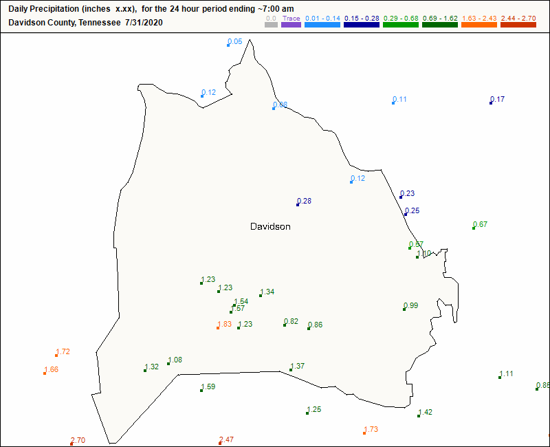
A Tolerable Form of “Hot” on Saturday

Hear me out. It *sounds* hot outside today! It’s 10 am and the cicadas are already out chirping in full force.

Few clouds out this morning to provide relief from the sun. Today will be the first August day of this year to surpass 90º. That’s not very “on brand” for 2020, but I’m not complaining! Lucky for us, our dew points are still hanging out right around 65º. Hence, the “pleasant” heat. read more

We Could Get Used to This! (But You Probably Shouldn’t.)

The beautiful weather that you woke up to will continue throughout the day today.

We can thank an upper level trough that’s decided to sit above the eastern US this week. Moisture will continue to stay to our south, causing the dew point map to look like this: read more

Rainy Forecast for a Couple More Days, Followed by a Pleasant Beginning-Of-August “Cool” Down

Friday Afternoon Rain Raises Localized Flooding Concerns

More showers will move through our area this afternoon, bringing an additional half inch to inch of rain. Localized flooding is the biggest concern today. Take a look at the amount of rain that has fallen in the past day in Davidson and Williamson counties, through 7am this morning: read more

Possibility for Plan-Altering Rain This Afternoon; A Cold Front Coming Our Way Next Week

Saturday: Be Aware of Heat Index and Scattered Thunderstorms

Same forecast. Again.

The dewpoint will hover around 72º all day, making for a heat index just under 100º.

Watch for scattered thunderstorms starting late morning and extending to sunset this evening. Predicting storm locations in the summer is near impossible, especially this far ahead of time. Here is the HRRR’s best estimate of where and when storms will arrive: read more

Bringing the Heat Today; A Few Degrees of Relief and Higher Rain Chances Later this Week

A Hot, Potentially Stormy Start to the Week

You know the drill by now: hot and humid today, with a chance for scattered showers this afternoon.

The dewpoint will hover around 71º. As of 11am, the heat index at BNA was already 100º, so I wouldn’t be surprised if we approached a heat index near 105º by this afternoon. If the temp soars, the humidity will come down a bit. But if not, the humidity will stick around. Either way: read more

Not All 96º Days Are The Same: Bad Today, Worse Thursday Through the Weekend. Plan Outdoor Activities for the Morning.

Heat Approaching Dangerous Levels Today

The heat arrives in full force today. It will be compounded by full sun and no chance for rain.

Lucky for us, the humidity will begin to build after the peak daytime heating. The heat index will just miss 100º. Notice below how the most humid air (in brown) is stuck just to our west. read more

A Healthy Dose of Summer Temperatures Tomorrow

Lower Rain Chances. Tradeoff: Hotter Temperatures.

The heat index was over 100º today.

The winds were around 10-15mph. Earlier this evening it was just enough wind to make it feel a couple degrees cooler. Temporarily at least. read more

You Guessed It: Hot, Oppressive Humidity, and a Chance of Afternoon Storms

Storms are Likely Today, Maybe in Your Backyard

Storms should start forming once we hit 91°, which we’ll do shortly after lunch.

Storm Timing

The HRRR model predicts rain and storms bubbling up in Middle Tennessee starting around 2 PM. This should continue through the afternoon into the early evening. Storms should start to fizzle out around sunset and completely clear the area by midnight tonight. Here is where the HRRR predicts the storms’ general whereabouts this afternoon: read more

More Rain Around Today (but will it get you?), Maybe a Pause Button on the Rain?

Scattered Showers will Continue Throughout the Day, But Will We Get Any?

Storm Threats

We are not included in the SPC outlook regions for tornadoes, wind, or hail. The biggest threats with any storms we will receive today are lightning and downpours. read more

Cold(-ish) Front Arrives Today; Then the Return of Heat and Soup-Like Air

Tuesday, Rain will Taper off by Early Afternoon

Here comes the cold front! It will bring a few scattered showers and thunderstorms to Middle Tennessee this morning. Most of the rain associated with this system fell before sunrise, though. Here’s this morning’s run of the HRRR model, through midnight tonight: read more